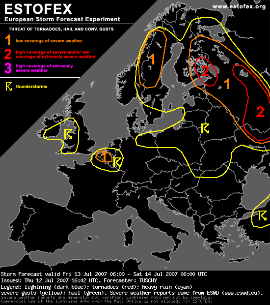
... NE-France, Belgium, the Netherlands and extreme western Germany...
Aforementioned LL depression over UK supports not only an intense warm-up process over the area of interest but also a significant increase of surface dewpoints. Yesterday afternoon,dewpoints of 15-19°C were common over NW France while spreading eastwards.
Mid-levels will stay warm, but strong diabatic heating ( ~ 25°C ) and dewpoints in the upper tens should help to release some low-end instability. EL values also indicate that deep convection will be indeed a distinct possibility and DLS of 15m/s and up to 200 J/kg SRH3 values will be present, too.
Belgium should be the focus for a few severe thunderstorms with large hail as the main threat, if trends in latest model output won't change significantly.
Even an isolated tornado can't be ruled out as LL shear constantly increases during the late afternoon / early evening hours and LCLs stay low.
Ben benieuwd
Gr Youri
Aforementioned LL depression over UK supports not only an intense warm-up process over the area of interest but also a significant increase of surface dewpoints. Yesterday afternoon,dewpoints of 15-19°C were common over NW France while spreading eastwards.
Mid-levels will stay warm, but strong diabatic heating ( ~ 25°C ) and dewpoints in the upper tens should help to release some low-end instability. EL values also indicate that deep convection will be indeed a distinct possibility and DLS of 15m/s and up to 200 J/kg SRH3 values will be present, too.
Belgium should be the focus for a few severe thunderstorms with large hail as the main threat, if trends in latest model output won't change significantly.
Even an isolated tornado can't be ruled out as LL shear constantly increases during the late afternoon / early evening hours and LCLs stay low.
Ben benieuwd
Gr Youri