Nja saai precies tussen 2 gebieden  . Als er eens veel shear is voor een supercel/tornado's zijn er wel andere factoren die het weer tegenhouden zekers in het benelux tss!!.
(Enkele buien zijn wel niet uit te sluiten vandaag!).
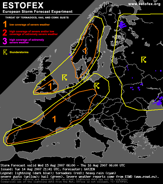
Storm Forecast
Valid: Wed 15 Aug 2007 06:00 to Thu 16 Aug 2007 06:00 UTC
Issued: Tue 14 Aug 2007 21:41
Forecaster: GATZEN
SYNOPSIS
High geopotential dominates eastern Europe. An embedded cut-off low is present over the Ukraine. Over western Europe, axis of amplified and intense long-wave trough extends from Shetland Islands to western Ibenian Peninsula on Wednesday, 12Z. It rotates counter-clockwise, and the trough axis will move across England, north-western France, and most of Iberian Peninsula during the period. Ahead of associated cold front, a strong south-westerly flow will be present.
DISCUSSION
Southern British Isles
A very strong upper jet streak moves north-eastward ahead of the mentioned trough axis. It is expected over south-western British Isles on Wednesday, 12Z. At the cyclonic flank of this jet streak, strong QG forcing is expected due to strong DCVA as well as WAA east of propagating surface cold front. At low levels, rich boundary-layer moisture indicated by latest ascends will spread north-eastward into south-western British Isles, and low-level dewpoints in excess of 15°C are forecast. Given mid-level cooling in the range of the propagating trough-axis, GFS CAPE calculation seems to be reasonable. Thunderstorms are forecast to develop along the cold front. Given strong vertical wind shear, multicells and bowing lines are forecast, capable of producing high winds and isolated large hail. Although low-level veering is expected to be not very strong, a few tornadoes are not ruled out in the highly-sheared environment. Limiting factor will be rather dry low-level air mass that may advect into southern British Isles during the day, and chance for severe convection will likely weaken during the period.
Northern Spain to central Germany
A strong south-westerly flow affects the region during the period that advects rather warm air from the Iberian Peninsula north-eastward. In the range of this warm air mass, mid-level lapse rates are forecast to steepen as the upper trough approaches. Additionally, models suggest that low-level moisture pooling will lead to substantial moisture in the range of the warm air axis or just north of it in the WAA regime over Germany. Given some diurnal heating, CAPE may build. Given rather weak actual lapse rates and especially poor low-level moisture, amount of instbility is questionable. However, expect that at least weak instability will form, initiation may still be a problem as low-level forcing is limited. QG forcing may be quite strong in the range of the upper jet streak especially in the evening hours when the jet axis accelerates eastward. Showers and thunderstorms are forecast to form that may be elevated due to poor low-level moisture. Given strong DLS of 30 m/s, storms will likely organize, capable of producing severe wind gusts and large hail. Storms that root to the boundary-layer may produce tornadoes given strong LLS, especially over western Alps, eastern France, and south-western Germany in the afternoon/evening hours. Given great uncertainties about low-level moisture, decide to issue a level 1. Later oberservations may lead to an upgrade during the period.
. Als er eens veel shear is voor een supercel/tornado's zijn er wel andere factoren die het weer tegenhouden zekers in het benelux tss!!.(Enkele buien zijn wel niet uit te sluiten vandaag!).
Storm Forecast
Valid: Wed 15 Aug 2007 06:00 to Thu 16 Aug 2007 06:00 UTC
Issued: Tue 14 Aug 2007 21:41
Forecaster: GATZEN
SYNOPSIS
High geopotential dominates eastern Europe. An embedded cut-off low is present over the Ukraine. Over western Europe, axis of amplified and intense long-wave trough extends from Shetland Islands to western Ibenian Peninsula on Wednesday, 12Z. It rotates counter-clockwise, and the trough axis will move across England, north-western France, and most of Iberian Peninsula during the period. Ahead of associated cold front, a strong south-westerly flow will be present.
DISCUSSION
Southern British Isles
A very strong upper jet streak moves north-eastward ahead of the mentioned trough axis. It is expected over south-western British Isles on Wednesday, 12Z. At the cyclonic flank of this jet streak, strong QG forcing is expected due to strong DCVA as well as WAA east of propagating surface cold front. At low levels, rich boundary-layer moisture indicated by latest ascends will spread north-eastward into south-western British Isles, and low-level dewpoints in excess of 15°C are forecast. Given mid-level cooling in the range of the propagating trough-axis, GFS CAPE calculation seems to be reasonable. Thunderstorms are forecast to develop along the cold front. Given strong vertical wind shear, multicells and bowing lines are forecast, capable of producing high winds and isolated large hail. Although low-level veering is expected to be not very strong, a few tornadoes are not ruled out in the highly-sheared environment. Limiting factor will be rather dry low-level air mass that may advect into southern British Isles during the day, and chance for severe convection will likely weaken during the period.
Northern Spain to central Germany
A strong south-westerly flow affects the region during the period that advects rather warm air from the Iberian Peninsula north-eastward. In the range of this warm air mass, mid-level lapse rates are forecast to steepen as the upper trough approaches. Additionally, models suggest that low-level moisture pooling will lead to substantial moisture in the range of the warm air axis or just north of it in the WAA regime over Germany. Given some diurnal heating, CAPE may build. Given rather weak actual lapse rates and especially poor low-level moisture, amount of instbility is questionable. However, expect that at least weak instability will form, initiation may still be a problem as low-level forcing is limited. QG forcing may be quite strong in the range of the upper jet streak especially in the evening hours when the jet axis accelerates eastward. Showers and thunderstorms are forecast to form that may be elevated due to poor low-level moisture. Given strong DLS of 30 m/s, storms will likely organize, capable of producing severe wind gusts and large hail. Storms that root to the boundary-layer may produce tornadoes given strong LLS, especially over western Alps, eastern France, and south-western Germany in the afternoon/evening hours. Given great uncertainties about low-level moisture, decide to issue a level 1. Later oberservations may lead to an upgrade during the period.