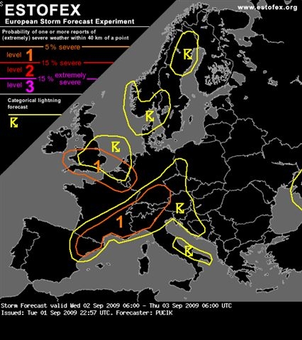
A level 1 was issued for Wales, Southern England, Bretagne and Belgium mainly for tornadoes and severe wind gusts.
... Wales, Southern England, Bretagne, Belgium...
Being placed under the left exit region of the strong jet-stream and ahead of the mid level impulse, a favorable forcing should be available in the late evening and night hours. Prediction of potential vorticity shows the likely intrusion of drier, stratospheric air to the rear side of the advancing cold front. Models are not quite in agreement regarding the instability, GFS simulates at least marginal values of MLCAPE, mostly over England within the area of strong forcing. ECMWF is more conservative and at the moment, it is difficult to say, how much instability will materialize during this event. It seems quite probable, that strong low level shear will be present in this situation with its values well over 10 m/s locally. Moreover, a band of enhanced SREH, over 200 J/kg for 0-1 km layer should form just ahead of the cold front. A detrimental factor to the organised convection should be quite weak shear in 0-3 or 0-6 km layer with values around 10-15 m/s, impliyng a low chance that a well organised, strongly forced convective line forms.
Although there are still many uncertainities regarding the evolution of the convection around the cold front, there is a slight chance that some weak tornadoes occur with stronger convective elements that might acquire rotation briefly. Also with more than 20 m/s at 850 hPa level, severe wind gusts might occur as well. The threat will be most prominent around 21Z for England and between 03Z-06Z for European part of Level 1, probably continuing into the next forecast period. An update might become necessary later on if situation changes
... Wales, Southern England, Bretagne, Belgium...
Being placed under the left exit region of the strong jet-stream and ahead of the mid level impulse, a favorable forcing should be available in the late evening and night hours. Prediction of potential vorticity shows the likely intrusion of drier, stratospheric air to the rear side of the advancing cold front. Models are not quite in agreement regarding the instability, GFS simulates at least marginal values of MLCAPE, mostly over England within the area of strong forcing. ECMWF is more conservative and at the moment, it is difficult to say, how much instability will materialize during this event. It seems quite probable, that strong low level shear will be present in this situation with its values well over 10 m/s locally. Moreover, a band of enhanced SREH, over 200 J/kg for 0-1 km layer should form just ahead of the cold front. A detrimental factor to the organised convection should be quite weak shear in 0-3 or 0-6 km layer with values around 10-15 m/s, impliyng a low chance that a well organised, strongly forced convective line forms.
Although there are still many uncertainities regarding the evolution of the convection around the cold front, there is a slight chance that some weak tornadoes occur with stronger convective elements that might acquire rotation briefly. Also with more than 20 m/s at 850 hPa level, severe wind gusts might occur as well. The threat will be most prominent around 21Z for England and between 03Z-06Z for European part of Level 1, probably continuing into the next forecast period. An update might become necessary later on if situation changes
 )
)
