High chance that model performance will dip over the next few days.
We have a complex trough developing in the Atlantic whilst the progression of the MJO in the Pacific looks very problematic right now. Add to that, tendency in angular momentum plots are showing a sharp increase in westerly winds around 50N (polar jet flow increased) c/o mountain torques, that translates to real issues to resolve so sticking with ensemble mean guidance would appear the best way forward.
The GWO is just in phase 4:
http://www.esrl.noaa.gov/psd/map/images/gcm/gwo_40d.gif
I think a continutation in phase 4 looks a reasonable assumption for the next 5-10 days given the state of angular momentum.
I posted a day ot two ago that the composites for phase 4 were a bit ambiguous. In light of model outputs over the last 24 hours, these now make sense....
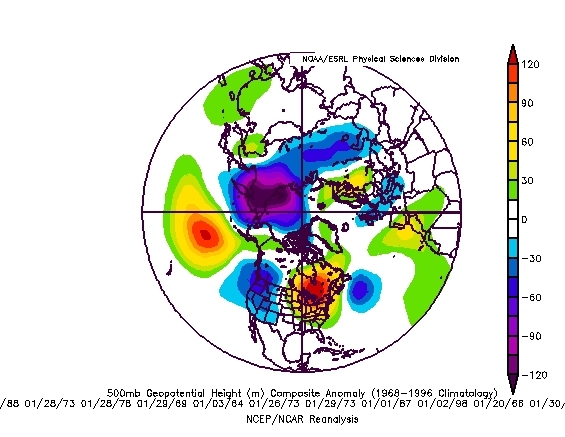
a weak trough centred over the UK with ridge in place to the west. Given the pattern of the last few weeks, SSTA which favour a -NAO and upwelling wave in the upper troposphere, we should expect some +VE height anomaly to our north and north-east forcing the jet on a more southward tack.
This looks a reasonable solution for days 8-14. On this basis, any break in the cold pattern looks unlikely. Atlantic airmasses will attempt to work in - that is the nature of any trough, however, the degree of modification of the lower layers looks open to doubt and we must ask the question, what happens if the trough remains in place for any duration ? The most likely solution is for the longwave pattern to put an upper ridge behind the trough which builds over the top to perpetuate the surface cold for an extended period.
Next week continues to look like an increasing snow threat. Becoming less cold from the west is quite possible although any ridge building in from the west will sustain cold and there is the nagging suspicion that the tendency will be for higher pressure to the north and north-east which will maintain an easterly feed.
als altijd gevonden op netweather
We have a complex trough developing in the Atlantic whilst the progression of the MJO in the Pacific looks very problematic right now. Add to that, tendency in angular momentum plots are showing a sharp increase in westerly winds around 50N (polar jet flow increased) c/o mountain torques, that translates to real issues to resolve so sticking with ensemble mean guidance would appear the best way forward.
The GWO is just in phase 4:
http://www.esrl.noaa.gov/psd/map/images/gcm/gwo_40d.gif
I think a continutation in phase 4 looks a reasonable assumption for the next 5-10 days given the state of angular momentum.
I posted a day ot two ago that the composites for phase 4 were a bit ambiguous. In light of model outputs over the last 24 hours, these now make sense....
a weak trough centred over the UK with ridge in place to the west. Given the pattern of the last few weeks, SSTA which favour a -NAO and upwelling wave in the upper troposphere, we should expect some +VE height anomaly to our north and north-east forcing the jet on a more southward tack.
This looks a reasonable solution for days 8-14. On this basis, any break in the cold pattern looks unlikely. Atlantic airmasses will attempt to work in - that is the nature of any trough, however, the degree of modification of the lower layers looks open to doubt and we must ask the question, what happens if the trough remains in place for any duration ? The most likely solution is for the longwave pattern to put an upper ridge behind the trough which builds over the top to perpetuate the surface cold for an extended period.
Next week continues to look like an increasing snow threat. Becoming less cold from the west is quite possible although any ridge building in from the west will sustain cold and there is the nagging suspicion that the tendency will be for higher pressure to the north and north-east which will maintain an easterly feed.
als altijd gevonden op netweather
Bericht laatst bijgewerkt: 08-01-2010 22:17
„Et nul ne se connait tant qu'il n'a pas souffert, „C'est une dure loi, mais une loi suprème, „Vieille comme le monde et la fatalité, „Qu'l nous faut du malheur regevoir le baptéme, ~Et qu'a ce triste prix tout doit étre acheté. „Les moissons pour murir out besoin de rosée, „Pour vivre et pour sentir l'homme a besoin de pleura, „La joie a pour symbole une plante brisée, „Humide encore de pluie et couverte de fleurs."