Latest ECM update and thoughts.
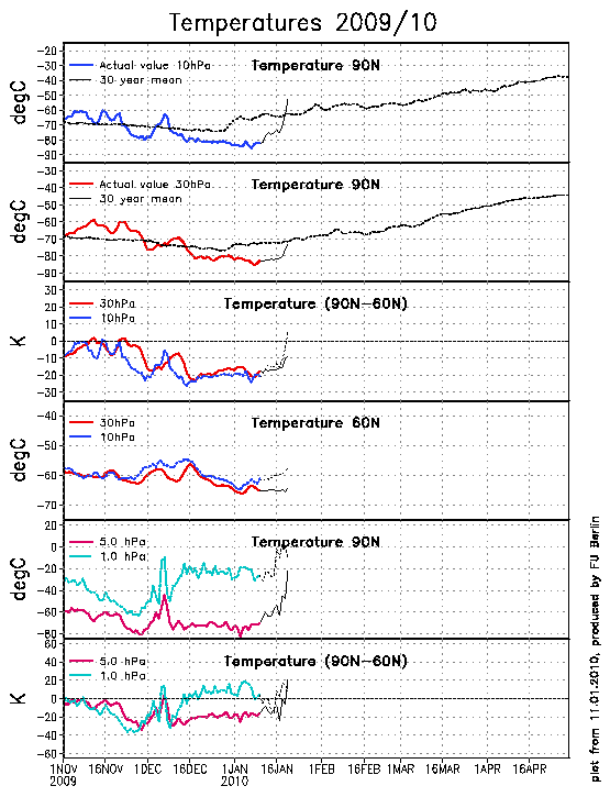
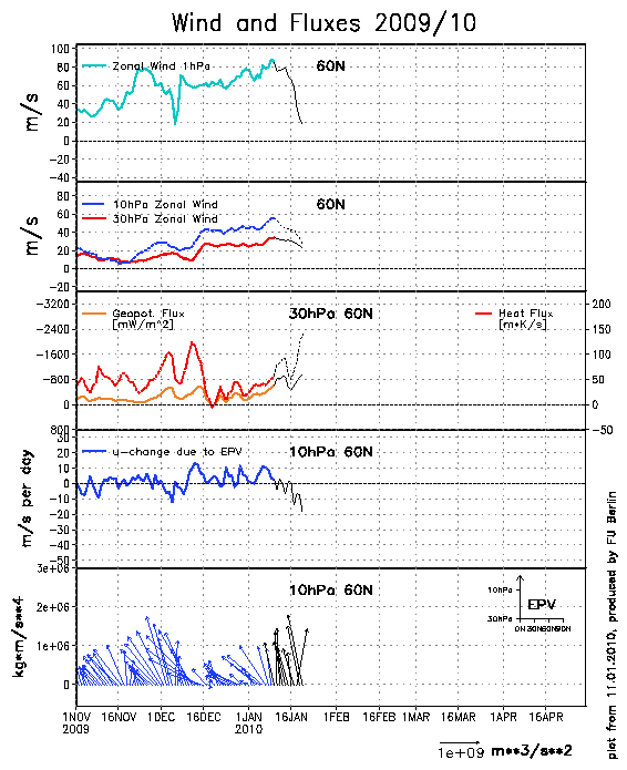
Well the latest update is promising and shows an increased possibility for a displacement MMW to occur. Strong wave 1 activity is fluxing heat polewards and we can see the effects of this with a rapid deceleration of vortex winds at the 1hPa level.
This is now forecast to propagate down to lower levels and we can see that a dramatic rise in temperatures is forecast at the 10 hPa level and the start of a rise at the 30 hPa level.
The shape of the vortex is very distorted at these levels with considerable forcing and squeezing of the vortex towards Siberia. If this continues then I don't think it will be long before we have a full displacement.
I have changed my thoughts since yesterday about how this may affect us in the short / mid term. Firstly, the planned split in the lower stratospheric vortex and tropospheric vortex looks unlikely to occur, with a banana shaped vortex taking residence instead. My feelings, having looked at the temperature and zonal wind profiles of the stratosphere, is that the push from above is initially going to drive down the positive zonal winds, that have been kept at bay in the middle stratosphere, towards the troposphere. This initially is going to reinforce the tropospheric polar vortex, which, even though it may not be situated directly over the North Pole, may give it enough oomph to hold the Scandinavian High at bay and displace it more towards Siberia. This may serve to allow a temporary spell of milder weather before the Scandi High regains strength and any effects of a MMW are felt. So in essence, the short term effects of a MMW may actually be detrimental to the pattern of winter weather that we have experienced so far.
bron: netweather
Well the latest update is promising and shows an increased possibility for a displacement MMW to occur. Strong wave 1 activity is fluxing heat polewards and we can see the effects of this with a rapid deceleration of vortex winds at the 1hPa level.
This is now forecast to propagate down to lower levels and we can see that a dramatic rise in temperatures is forecast at the 10 hPa level and the start of a rise at the 30 hPa level.
The shape of the vortex is very distorted at these levels with considerable forcing and squeezing of the vortex towards Siberia. If this continues then I don't think it will be long before we have a full displacement.
I have changed my thoughts since yesterday about how this may affect us in the short / mid term. Firstly, the planned split in the lower stratospheric vortex and tropospheric vortex looks unlikely to occur, with a banana shaped vortex taking residence instead. My feelings, having looked at the temperature and zonal wind profiles of the stratosphere, is that the push from above is initially going to drive down the positive zonal winds, that have been kept at bay in the middle stratosphere, towards the troposphere. This initially is going to reinforce the tropospheric polar vortex, which, even though it may not be situated directly over the North Pole, may give it enough oomph to hold the Scandinavian High at bay and displace it more towards Siberia. This may serve to allow a temporary spell of milder weather before the Scandi High regains strength and any effects of a MMW are felt. So in essence, the short term effects of a MMW may actually be detrimental to the pattern of winter weather that we have experienced so far.
bron: netweather
„Et nul ne se connait tant qu'il n'a pas souffert, „C'est une dure loi, mais une loi suprème, „Vieille comme le monde et la fatalité, „Qu'l nous faut du malheur regevoir le baptéme, ~Et qu'a ce triste prix tout doit étre acheté. „Les moissons pour murir out besoin de rosée, „Pour vivre et pour sentir l'homme a besoin de pleura, „La joie a pour symbole une plante brisée, „Humide encore de pluie et couverte de fleurs."