zelden zulke kaarten gezien
erg benieuwd hoe dit verder gaat, blokkade lijkt te gaan verdwijnen, hogedruk zakkend naar het zuiden? ligt ook een lagedrukgebiedje die zakken verhindert, nieuwe WA vormt, of lijkt dat maar zo? Mijn inschatting is (alle modellen komen met lagedruk bij de azoren) dat hogedruk even kan inzakken, maar na 168 uur weer versterkt.
Van hogedrukvorming boven Scandinavie is geen sprake.
forumlid Netweather zegt het zo
This is why when a model run comes out I like to view the meteociel northern hemisphere charts as this shows what is going on all over the hemisphere and not just our neck of the woods.
The ridging over western and central America into the Arctic with the MMW aiding this + the MJO also the splitting of the vortex.
Posters were talking of topplers but just looking at these charts you could see the Atlantic ridge was getting help from the Arctic high just like the last two cold spells.
Its what happens to the Arctic high, if it comes over our side of the pole or the vortex splits more favorably then it is game on for a very long cold spell. At the moment the high is modeled to link up with the Siberian high but at 6+ days out all is to play for.
The longer the Arctic high links with the ridge from the Atlantic the longer the cold spell.
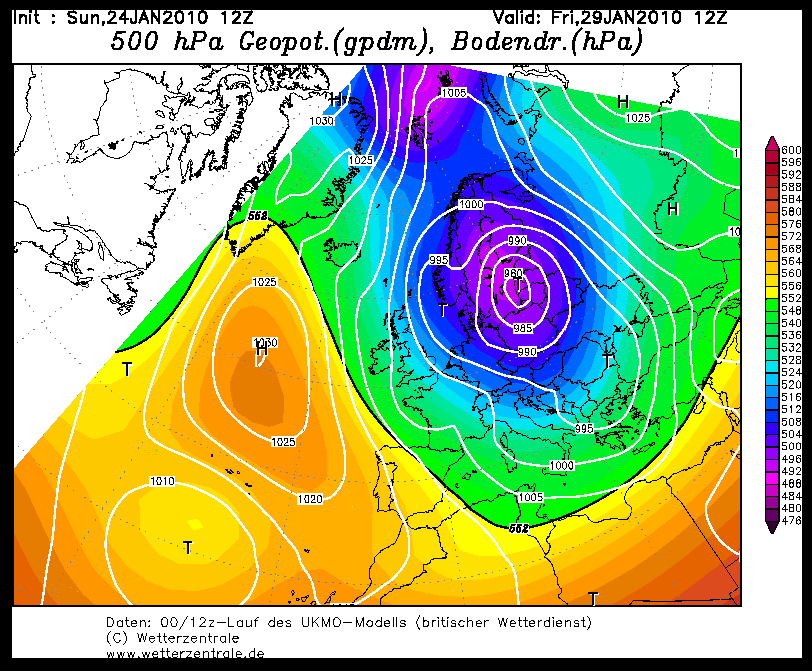
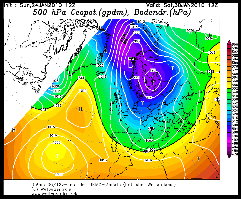
erg benieuwd hoe dit verder gaat, blokkade lijkt te gaan verdwijnen, hogedruk zakkend naar het zuiden? ligt ook een lagedrukgebiedje die zakken verhindert, nieuwe WA vormt, of lijkt dat maar zo? Mijn inschatting is (alle modellen komen met lagedruk bij de azoren) dat hogedruk even kan inzakken, maar na 168 uur weer versterkt.
Van hogedrukvorming boven Scandinavie is geen sprake.
forumlid Netweather zegt het zo
This is why when a model run comes out I like to view the meteociel northern hemisphere charts as this shows what is going on all over the hemisphere and not just our neck of the woods.
The ridging over western and central America into the Arctic with the MMW aiding this + the MJO also the splitting of the vortex.
Posters were talking of topplers but just looking at these charts you could see the Atlantic ridge was getting help from the Arctic high just like the last two cold spells.
Its what happens to the Arctic high, if it comes over our side of the pole or the vortex splits more favorably then it is game on for a very long cold spell. At the moment the high is modeled to link up with the Siberian high but at 6+ days out all is to play for.
The longer the Arctic high links with the ridge from the Atlantic the longer the cold spell.
Bericht laatst bijgewerkt: 24-01-2010 18:37
„Et nul ne se connait tant qu'il n'a pas souffert, „C'est une dure loi, mais une loi suprème, „Vieille comme le monde et la fatalité, „Qu'l nous faut du malheur regevoir le baptéme, ~Et qu'a ce triste prix tout doit étre acheté. „Les moissons pour murir out besoin de rosée, „Pour vivre et pour sentir l'homme a besoin de pleura, „La joie a pour symbole une plante brisée, „Humide encore de pluie et couverte de fleurs."