Stratospheric signals are still improving day by day to support a cold spell. it has to be said that they are a lot better than this time last week when there was uncertainty about Atlantic and Scandi trough linkage.
The next phase of vortex disruption looks set to occur within five days. So far with this warming event we have seen the vortex severely displaced from the pole which has weakened it considerably. This has not been quite enough to create a MMW, however the next phase of disruption looks set to qualify. This involves the displaced vortex splitting into two. This forecast split is set to progress right through the stratosphere and troposphere unlike the partial splits seen earlier this winter. The initial effects from this split are likely to be felt as ridging around Iceland with the residual vortices remaining as troughs either side.
This year the way the stratosphere is behaving is totally different to last years. Last year we had a record breaking MMW that after the initial impact failed to give any sustained tropospheric response. This winter we have seen a warmer than average stratosphere to start the winter and now a prolonged stratospheric warming episode that is about to lead us into a MMW. The troposphere has responded to this all winter.
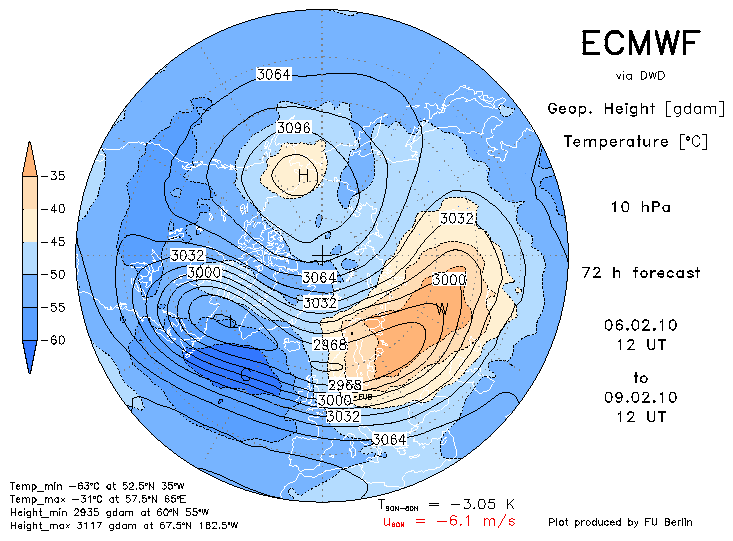
The Forecast MMW is set to occur on the 9th of February. Remember the mean zonal mean winds need to reverse at 10 hPa and 60ºN for this to occur.
afbeelding 1
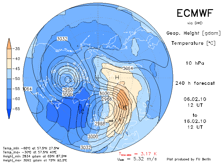
This is caused by the previously displaced vortex, that came very close to a MMW last month, splitting into two daughter vortices. By day 10 these daughter vortices are positioned in the middle stratosphere as thus:
afbeelding 2
I can't remember ever seeing a stratospheric split vortex profile following other MMW's such as this and is probably down to the fact that the vortex displaced prior to splitting so this could be a bit of uncharted territory here for computer models.
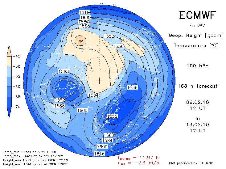
This translates closer to the troposphere as a pattern such as this at 100 hPa by day 7:
afbeelding 3
Again a very unusual pattern that probably hasn't been seen for years. Note that this could lead to the UK being in a potentially very cold NE airstream at this time with ridging splitting the main vortex components. Also the mean zonal winds are negative!
These negative mean zonal winds have been repeatedly suggested at the tropospheric surface between 50-60ºN. That to me suggests that we are likely to have a trend of higher pressure wedged slightly north of us but not necessarily dropping. Furthermore there are indications that these negative zonal wind anomalies will extend further north as the month progresses. A colder than average February is extremely likely imo.
afbeelding 1-2-3
Bron netweather
The next phase of vortex disruption looks set to occur within five days. So far with this warming event we have seen the vortex severely displaced from the pole which has weakened it considerably. This has not been quite enough to create a MMW, however the next phase of disruption looks set to qualify. This involves the displaced vortex splitting into two. This forecast split is set to progress right through the stratosphere and troposphere unlike the partial splits seen earlier this winter. The initial effects from this split are likely to be felt as ridging around Iceland with the residual vortices remaining as troughs either side.
This year the way the stratosphere is behaving is totally different to last years. Last year we had a record breaking MMW that after the initial impact failed to give any sustained tropospheric response. This winter we have seen a warmer than average stratosphere to start the winter and now a prolonged stratospheric warming episode that is about to lead us into a MMW. The troposphere has responded to this all winter.
The Forecast MMW is set to occur on the 9th of February. Remember the mean zonal mean winds need to reverse at 10 hPa and 60ºN for this to occur.
afbeelding 1
This is caused by the previously displaced vortex, that came very close to a MMW last month, splitting into two daughter vortices. By day 10 these daughter vortices are positioned in the middle stratosphere as thus:
afbeelding 2
I can't remember ever seeing a stratospheric split vortex profile following other MMW's such as this and is probably down to the fact that the vortex displaced prior to splitting so this could be a bit of uncharted territory here for computer models.
This translates closer to the troposphere as a pattern such as this at 100 hPa by day 7:
afbeelding 3
Again a very unusual pattern that probably hasn't been seen for years. Note that this could lead to the UK being in a potentially very cold NE airstream at this time with ridging splitting the main vortex components. Also the mean zonal winds are negative!
These negative mean zonal winds have been repeatedly suggested at the tropospheric surface between 50-60ºN. That to me suggests that we are likely to have a trend of higher pressure wedged slightly north of us but not necessarily dropping. Furthermore there are indications that these negative zonal wind anomalies will extend further north as the month progresses. A colder than average February is extremely likely imo.
afbeelding 1-2-3
Bron netweather
„Et nul ne se connait tant qu'il n'a pas souffert, „C'est une dure loi, mais une loi suprème, „Vieille comme le monde et la fatalité, „Qu'l nous faut du malheur regevoir le baptéme, ~Et qu'a ce triste prix tout doit étre acheté. „Les moissons pour murir out besoin de rosée, „Pour vivre et pour sentir l'homme a besoin de pleura, „La joie a pour symbole une plante brisée, „Humide encore de pluie et couverte de fleurs."