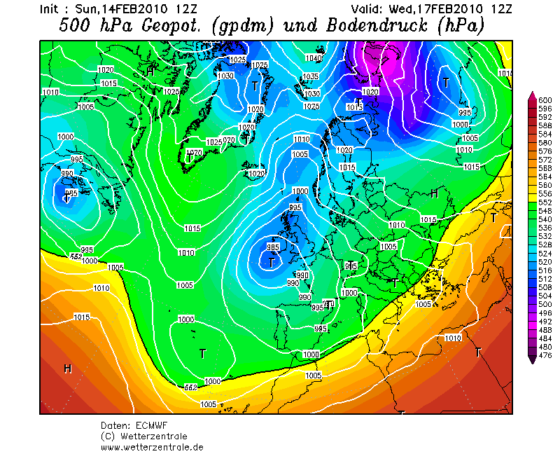
Ik ben benieuwd waar EC mee komt, onderstaande tekst vond ik nog op netweather.
The GFS refuses to amplify the upstream eastern USA trough, this then leads to a less favourable block over Greenland which then stops pressure rising towards Svalbard and keeps lower heights over Scandi. So if the GFS calls the upstream wrong then its later output can't verify.
You have to look at its output in the context of the upstream PNA pattern, NOAA think its wrong and suggested this earlier today. They've gone with the ECM this morning because it amplified the upstream pattern more. I'll repost this quote from their earlier discussions.
WHILE THE GFS FORECAST OF THE PNA
PATTERN IS NEAR NEUTRAL WITH A CONTINUATION OF THE VERY STRONGLY NEGATIVE AO/NAO BELIEVE THE LONGER TERM GFS IN ERROR AND THE STRONGER PNA TYPE PATTERN SUGGESTED BY THE ECMWF AND ITS ENS MEAN
OF A MORE AMPLIFIED SOLUTION OF A CENTRAL TO ERN CONUS TROF WILL PREVAIL. D+8 ANALOGS THAT BEST FIT A STRONG NEG AO/NAO AND WARM ENSO YEARS CONT TO BE FEB 1978 AND 1958.
So this in a nutshell is the crucial aspect of the upstream pattern, if the GFS is right then it's much more difficult to get to a much colder outlook, if the ECM is correct and its operational run sticks with the same trend then its likely to begin to show some much more interesting later output.
Looking at the UKMO upto 144hrs that has better heights to the north which hopefully is a good sign for tonights ECM.
The GFS refuses to amplify the upstream eastern USA trough, this then leads to a less favourable block over Greenland which then stops pressure rising towards Svalbard and keeps lower heights over Scandi. So if the GFS calls the upstream wrong then its later output can't verify.
You have to look at its output in the context of the upstream PNA pattern, NOAA think its wrong and suggested this earlier today. They've gone with the ECM this morning because it amplified the upstream pattern more. I'll repost this quote from their earlier discussions.
WHILE THE GFS FORECAST OF THE PNA
PATTERN IS NEAR NEUTRAL WITH A CONTINUATION OF THE VERY STRONGLY NEGATIVE AO/NAO BELIEVE THE LONGER TERM GFS IN ERROR AND THE STRONGER PNA TYPE PATTERN SUGGESTED BY THE ECMWF AND ITS ENS MEAN
OF A MORE AMPLIFIED SOLUTION OF A CENTRAL TO ERN CONUS TROF WILL PREVAIL. D+8 ANALOGS THAT BEST FIT A STRONG NEG AO/NAO AND WARM ENSO YEARS CONT TO BE FEB 1978 AND 1958.
So this in a nutshell is the crucial aspect of the upstream pattern, if the GFS is right then it's much more difficult to get to a much colder outlook, if the ECM is correct and its operational run sticks with the same trend then its likely to begin to show some much more interesting later output.
Looking at the UKMO upto 144hrs that has better heights to the north which hopefully is a good sign for tonights ECM.
„Et nul ne se connait tant qu'il n'a pas souffert, „C'est une dure loi, mais une loi suprème, „Vieille comme le monde et la fatalité, „Qu'l nous faut du malheur regevoir le baptéme, ~Et qu'a ce triste prix tout doit étre acheté. „Les moissons pour murir out besoin de rosée, „Pour vivre et pour sentir l'homme a besoin de pleura, „La joie a pour symbole une plante brisée, „Humide encore de pluie et couverte de fleurs."
