DISCUSSION
... N-Spain, France, Belgium and the Netherlands ...
From a synoptic point of view, the mover for thunderstorm initiation is an upper trough over UK/Ireland and Scotland. This feature amplifies furthermore during the forecast period, as a 60 m/s speed maximum at 300 hPa dives into the upstream side of that trough. A sharp cyclonic kink in high-level streamline pattern evolves over the Bay of Biscay, as favorable exit/entrance pattern gets established. This scenario has some effects further downstream over France, as WAA intensifies once again with rising geopotential heights forecast by all models. It is a bit hard to determine a single forcing mechanism, as eastward traveling vorticity lobe gets stretched in a SW-NE fashion over the Bay of Biscay and NW-France with probably better forcing available after sunset, as a potent short wave enters the Engish Channel from the west and traverse east/northeastwards. Therefore, a broad area will see adequate forcing for initiation with most widespread thunderstorm coverage building from Spain/S-Bay of Biscay northeastwards during the afternoon hours onwards. At the surface, a weak front moves in from the NW and affects NW/N-France after sunset in accord with best mid-/upper level lift, so confidence is high for scattered to widespread thunderstorm initiation during the evening and night hours.
CAPE fields are once again impressive over France and there are a few reasons to buy into that scenario. As the upper low amplifies, winds at all levels continue to back to a more southerly direction and therefore, a thick EML is able to spread from Spain to the north/northeast during the day. Yesterday at 18Z, surface dewpoints over S-France ranged between 15-22°C and keeping in mind that additional moisture from the Mediterranean may surge to the north and latest surface moisture analysis from the top 2 m surface layer reveals a modest positive bias over S-France, confidence exists for dewpoints in the upper tens over S and central France. Also, the moist surface layer ought to increase in depth, precluding daytime driven mixing (at least not comparable to the past few days). Further to the west and north, moisture pooling along the incoming front may also keep dewpoints well above 16°C, so we expect a warm sector, characterized by 800 to 1500 J/kg MLCAPE with locally higher maxima well possible. Despite ongoing WAA, intense diabatic heating helps to keep CIN values quite low over the warm sector.
Shear will be a limiting factor for widespread thunderstorm organisation in the warm sector. DLS increases to 15 - 20 m/s over W-/ N France, the Netherlands and Belgium with somewhat weaker 0-3 km shear. Nevertheless, directional shear is enhanced in the 0-1 km and 0-3km layers and some overlap of kinematic/thermodynamic fields may yield a favorable environment for organized storms along the front itself.
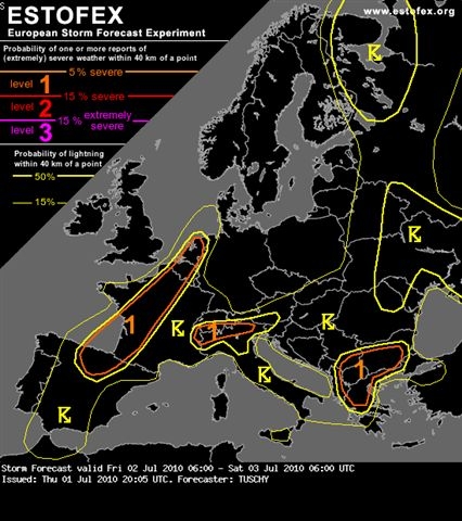
To summarize all that, we expect thunderstorm initiation already during the late morning hours from N-Spain all the way to the Netherlands, but more isolated to scattered in nature. Nevertheless, well organized multicells/isolated supercells are possible with an attendant large hail and strong wind gusts risk. Further east, over central/eastern France, a few thunderstorms may evolve during the peak time heating (afternoon hours) with abundant CAPE, weak shear and a very dry/mixed subcloud layer. Hence, isolated large hail and locally severe downbursts remain the main hazard, but too isolated for a level 1. Later on, during the evening hours, thunderstorms over N-Spain and SW-France increase in coverage and intensity, moving to the northeast. During the initiation stage, large hail (an isolated significant event is possible) and strong wind gusts remain the main hazard. Betimes, probably numerous thunderstorm clusters move over W-France northeastwards with an heavy rain, severe wind gusts and marginal hail risk. Also, an isolated tornado event is possible, given increasing LL directional shear and lower LCLs along the front itself. This activity also affects Belgium and the Netherlands during the night/morning hours. We decided to stick with a level 1 for now, as final moisture return and placement of the boundary remain a bit uncertain, but an upgrade may be performed later the day, if a more concentrated swath of severe events looks probable.
... N-Spain, France, Belgium and the Netherlands ...
From a synoptic point of view, the mover for thunderstorm initiation is an upper trough over UK/Ireland and Scotland. This feature amplifies furthermore during the forecast period, as a 60 m/s speed maximum at 300 hPa dives into the upstream side of that trough. A sharp cyclonic kink in high-level streamline pattern evolves over the Bay of Biscay, as favorable exit/entrance pattern gets established. This scenario has some effects further downstream over France, as WAA intensifies once again with rising geopotential heights forecast by all models. It is a bit hard to determine a single forcing mechanism, as eastward traveling vorticity lobe gets stretched in a SW-NE fashion over the Bay of Biscay and NW-France with probably better forcing available after sunset, as a potent short wave enters the Engish Channel from the west and traverse east/northeastwards. Therefore, a broad area will see adequate forcing for initiation with most widespread thunderstorm coverage building from Spain/S-Bay of Biscay northeastwards during the afternoon hours onwards. At the surface, a weak front moves in from the NW and affects NW/N-France after sunset in accord with best mid-/upper level lift, so confidence is high for scattered to widespread thunderstorm initiation during the evening and night hours.
CAPE fields are once again impressive over France and there are a few reasons to buy into that scenario. As the upper low amplifies, winds at all levels continue to back to a more southerly direction and therefore, a thick EML is able to spread from Spain to the north/northeast during the day. Yesterday at 18Z, surface dewpoints over S-France ranged between 15-22°C and keeping in mind that additional moisture from the Mediterranean may surge to the north and latest surface moisture analysis from the top 2 m surface layer reveals a modest positive bias over S-France, confidence exists for dewpoints in the upper tens over S and central France. Also, the moist surface layer ought to increase in depth, precluding daytime driven mixing (at least not comparable to the past few days). Further to the west and north, moisture pooling along the incoming front may also keep dewpoints well above 16°C, so we expect a warm sector, characterized by 800 to 1500 J/kg MLCAPE with locally higher maxima well possible. Despite ongoing WAA, intense diabatic heating helps to keep CIN values quite low over the warm sector.
Shear will be a limiting factor for widespread thunderstorm organisation in the warm sector. DLS increases to 15 - 20 m/s over W-/ N France, the Netherlands and Belgium with somewhat weaker 0-3 km shear. Nevertheless, directional shear is enhanced in the 0-1 km and 0-3km layers and some overlap of kinematic/thermodynamic fields may yield a favorable environment for organized storms along the front itself.
To summarize all that, we expect thunderstorm initiation already during the late morning hours from N-Spain all the way to the Netherlands, but more isolated to scattered in nature. Nevertheless, well organized multicells/isolated supercells are possible with an attendant large hail and strong wind gusts risk. Further east, over central/eastern France, a few thunderstorms may evolve during the peak time heating (afternoon hours) with abundant CAPE, weak shear and a very dry/mixed subcloud layer. Hence, isolated large hail and locally severe downbursts remain the main hazard, but too isolated for a level 1. Later on, during the evening hours, thunderstorms over N-Spain and SW-France increase in coverage and intensity, moving to the northeast. During the initiation stage, large hail (an isolated significant event is possible) and strong wind gusts remain the main hazard. Betimes, probably numerous thunderstorm clusters move over W-France northeastwards with an heavy rain, severe wind gusts and marginal hail risk. Also, an isolated tornado event is possible, given increasing LL directional shear and lower LCLs along the front itself. This activity also affects Belgium and the Netherlands during the night/morning hours. We decided to stick with a level 1 for now, as final moisture return and placement of the boundary remain a bit uncertain, but an upgrade may be performed later the day, if a more concentrated swath of severe events looks probable.