Was ook alweer aan het verzamelen geweest, dus bundel het hier maar even onder. Bedankt voor de loopjes, prachtige animaties!
Te beginnen met de kleintjes:
Te eindigen met de grote:
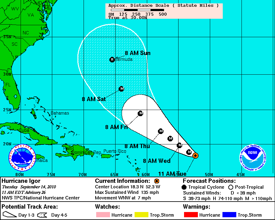
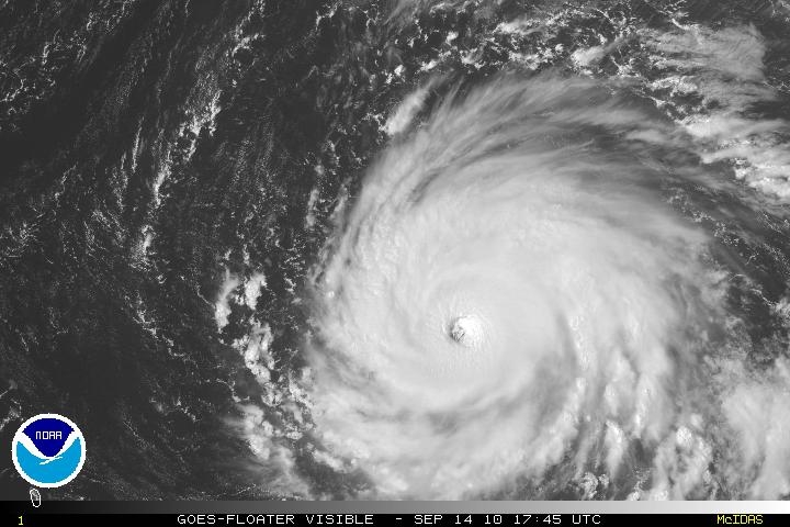
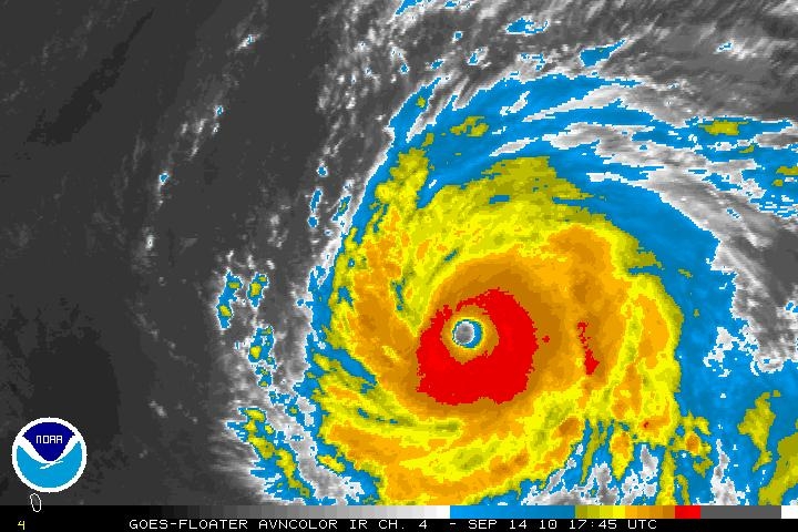
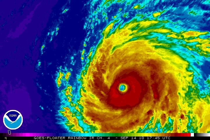
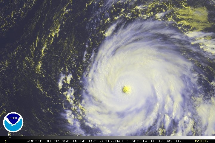
Hurricane Igor turns west-northwest
Hurricane Igor, shown here at 1145Z, September 14, continues to be a major hurricane and may remain so for the next 48-72 hours. The 5 day track has Igor threatening Bermuda, although the National Hurricane Center stresses that it is still too early assess Igor's potential impact on the island.

Hurricane Igor a Cat 4; Will Likely Spare U.S.
Hurricane Igor is currently at Category 4 intensity, with maximum sustained winds at 150 mph. The storm is expected to continue on its northwest path, but turning more north and out to see over the next few days. Though Bermuda may be threatened, most current forecast models do not show the storm impacting the mainland U.S. The image from the visible sensor on-board the GOES-East satellite was taken at 1315z on September 13, 2010.


Igor and Julia Strengthening in the Atlantic
This 1145Z GOES imagery, shows Igor east of the northern Leeward Islands. This system is traveling west near 13 MPH, with winds near 150 MPH. Igor is a category 4 hurricane and additional strengthening is possible over the next few days.
Tropical Storm Julia is located south-southwest of the Cape Verde Islands, with winds near 40 MPH. This system is moving west-northwest near 14 MPH. This system could become a hurricane within the next 12 to 24 hours.

September 14, 2010 - Hurricane Igor (11L) in the Atlantic Ocean
Dense storm bands filled with very heavy rain swirl around the distinct eye of Hurricane Igor shortly after the storm attained Category 4 Hurricane status. According to the National Hurricane Center (NHC) the eye measured approximately 23 miles (37 km) wide and sported an intense inner core ring of -80°C cloud top temperatures on September 12, 2010, near the time that this true-color image was captured by the Moderate Resolution Imaging Spectroradiometer (MODIS) aboard the Aqua satellite. Icy cold cloud tops and very heavy rainfall indicate a very powerful storm.
On the afternoon of September 12, Hurricane Igor was located about 1,120 mi (1,800 km) east of the northern Leeward Islands, with maximum sustained winds of 135 mph (215 km/hour). According to the Saffir-Simpson Hurricane Wind Scale, Category 4 Hurricanes have a wind speed of 131 – 155 mph (210 – 249 km/hr), and are strong enough to cause “catastrophic damage”. Fortunately, Hurricane Igor currently spins deep in the Tropical Atlantic Ocean and poses no imminent threat to land.
The storm continued as a strong Category 4 Hurricane on September 13, but winds speed had strengthened to maximum sustained of 150 mph (240 km/hr). Conditions are predicted to remain favorable for maintaining this intensity for the next 48 hours, after which a slow weakening should begin.
The storm continues to travel due west, 270 degrees, at 9 knots, and a turn towards the west-northwest is expected in the next 12 hours. The location is about 880 miles west of the Leeward Islands, and no land lies in the immediate predicted path, but the storm may pass close to Bermuda in about 5 days. The National Hurricane Center predicts that large swells will begin affecting the Leeward Islands by September 14, 2010 and reach Puerto Rico and the Virgin Islands the following day.
In Haiti, the country’s Civil Protection Agency has declared an “orange alert”, warning that several regions could be flooded. The government is also making plans to relocate thousands of people who remain in flood-prone displaced persons shelters after losing their homes following the 7.0 magnitude earthquake that ravaged the country on January 12, 2010.
Afbeelding:
Te beginnen met de kleintjes:
Te eindigen met de grote:
Hurricane Igor turns west-northwest
Hurricane Igor, shown here at 1145Z, September 14, continues to be a major hurricane and may remain so for the next 48-72 hours. The 5 day track has Igor threatening Bermuda, although the National Hurricane Center stresses that it is still too early assess Igor's potential impact on the island.
Hurricane Igor a Cat 4; Will Likely Spare U.S.
Hurricane Igor is currently at Category 4 intensity, with maximum sustained winds at 150 mph. The storm is expected to continue on its northwest path, but turning more north and out to see over the next few days. Though Bermuda may be threatened, most current forecast models do not show the storm impacting the mainland U.S. The image from the visible sensor on-board the GOES-East satellite was taken at 1315z on September 13, 2010.
Igor and Julia Strengthening in the Atlantic
This 1145Z GOES imagery, shows Igor east of the northern Leeward Islands. This system is traveling west near 13 MPH, with winds near 150 MPH. Igor is a category 4 hurricane and additional strengthening is possible over the next few days.
Tropical Storm Julia is located south-southwest of the Cape Verde Islands, with winds near 40 MPH. This system is moving west-northwest near 14 MPH. This system could become a hurricane within the next 12 to 24 hours.
September 14, 2010 - Hurricane Igor (11L) in the Atlantic Ocean
Dense storm bands filled with very heavy rain swirl around the distinct eye of Hurricane Igor shortly after the storm attained Category 4 Hurricane status. According to the National Hurricane Center (NHC) the eye measured approximately 23 miles (37 km) wide and sported an intense inner core ring of -80°C cloud top temperatures on September 12, 2010, near the time that this true-color image was captured by the Moderate Resolution Imaging Spectroradiometer (MODIS) aboard the Aqua satellite. Icy cold cloud tops and very heavy rainfall indicate a very powerful storm.
On the afternoon of September 12, Hurricane Igor was located about 1,120 mi (1,800 km) east of the northern Leeward Islands, with maximum sustained winds of 135 mph (215 km/hour). According to the Saffir-Simpson Hurricane Wind Scale, Category 4 Hurricanes have a wind speed of 131 – 155 mph (210 – 249 km/hr), and are strong enough to cause “catastrophic damage”. Fortunately, Hurricane Igor currently spins deep in the Tropical Atlantic Ocean and poses no imminent threat to land.
The storm continued as a strong Category 4 Hurricane on September 13, but winds speed had strengthened to maximum sustained of 150 mph (240 km/hr). Conditions are predicted to remain favorable for maintaining this intensity for the next 48 hours, after which a slow weakening should begin.
The storm continues to travel due west, 270 degrees, at 9 knots, and a turn towards the west-northwest is expected in the next 12 hours. The location is about 880 miles west of the Leeward Islands, and no land lies in the immediate predicted path, but the storm may pass close to Bermuda in about 5 days. The National Hurricane Center predicts that large swells will begin affecting the Leeward Islands by September 14, 2010 and reach Puerto Rico and the Virgin Islands the following day.
In Haiti, the country’s Civil Protection Agency has declared an “orange alert”, warning that several regions could be flooded. The government is also making plans to relocate thousands of people who remain in flood-prone displaced persons shelters after losing their homes following the 7.0 magnitude earthquake that ravaged the country on January 12, 2010.
Afbeelding:
@wthus (Twitter/Insta/Vero/Facebook) | Keerl, e-j zol eens wat meer moet’n doetinchemm’n | Bezoek ook: www.weerstation-dichteren.nl | www.buurmaaktnatuur.nl

