Alle modellen geven dat aan, en de condities zijn er naar.
Bericht van het PREDICT onderzoeksproject dat in de buurt gevlogen heeft:
"PREDICT NCAR-GV flight summary today. Mission is wrapping up and we found a bit of surprise...
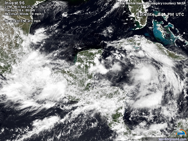
We found an elongated circulation stretching from the two main convective blobs from 19N, 85W to 18.5N, 80.5W. There is a large region of southwesterlies and westerlies N of Honduras and a very well defined circulation above the boundary layer at 700 mb. There is a very sharp wave or warm front-like axis at 925 mb with strongly veering winds with height along this boundary. Maximum near-surface winds are about 25 knots. This data surprised us as we expected to find a broad circulation, as seen in the models, but it appears something may be quickly developing around the vicinity of these two convective blobs in the NW Caribbean. If the circulation can consolidate some, then Nicole, or "Matthew's daughter" as we're calling it, may be born soon.
We'll be flying this same region tomorrow."
In Florida bereidt men zich reeds voor:
"FLORIDA EMERGENCY MANAGERS ENCOURAGE ALL RESIDENTS AND VISITORS TO
MONITOR TROPICAL DEVELOPMENTS THIS WEEKEND
TALLAHASSEE—Division of Emergency Management (DEM) officials are encouraging
Florida residents and visitors to closely monitor the progress of the current tropical system
in the Caribbean Sea and to update their family disaster plans and supply kits. No official
forecasts place Florida in the path of any tropical systems at this time, but favorable
conditions for rapid tropical development and strengthening do exist in the region."
Bericht van het PREDICT onderzoeksproject dat in de buurt gevlogen heeft:
"PREDICT NCAR-GV flight summary today. Mission is wrapping up and we found a bit of surprise...
We found an elongated circulation stretching from the two main convective blobs from 19N, 85W to 18.5N, 80.5W. There is a large region of southwesterlies and westerlies N of Honduras and a very well defined circulation above the boundary layer at 700 mb. There is a very sharp wave or warm front-like axis at 925 mb with strongly veering winds with height along this boundary. Maximum near-surface winds are about 25 knots. This data surprised us as we expected to find a broad circulation, as seen in the models, but it appears something may be quickly developing around the vicinity of these two convective blobs in the NW Caribbean. If the circulation can consolidate some, then Nicole, or "Matthew's daughter" as we're calling it, may be born soon.
We'll be flying this same region tomorrow."
In Florida bereidt men zich reeds voor:
"FLORIDA EMERGENCY MANAGERS ENCOURAGE ALL RESIDENTS AND VISITORS TO
MONITOR TROPICAL DEVELOPMENTS THIS WEEKEND
TALLAHASSEE—Division of Emergency Management (DEM) officials are encouraging
Florida residents and visitors to closely monitor the progress of the current tropical system
in the Caribbean Sea and to update their family disaster plans and supply kits. No official
forecasts place Florida in the path of any tropical systems at this time, but favorable
conditions for rapid tropical development and strengthening do exist in the region."
Bericht laatst bijgewerkt: 27-09-2010 22:11