Ik las op http://forum.netweather.tv/topic/64874-model-output-discussion/page__st__272 nog een aardige bijdrage. De score van het Groenlandhoog is bijna maximaal, schaal loopt tot 360! In de bespreking van EC12 van 16 november was er ook 1 tube. Dus we hebben te maken met een hogedrukgebied dat door alle(?) leden wordt verwacht.
Extremely impressive day 6-10 ECM ensemble mean H5 anomaly locating the block over Greenland giving a sustained period of 850hPa air temperture values around 4-6 below normal, locally 8-10 I suspect for much of NW Europe.
Worth noting that the hemispheric pattern is being prevented from being energised in the Pacific by that large ridge over the Aleutians. With that cold puddle of air over Europe and no upstream changes likely to open out the wavelengths, we are stuck in a cold rut.
Tonight's ESRL update to angular momentum budgets will be well worth monitoring as another mountain torque event is developing which is likely to have ramifications for re-strengthening of the block in the 15-20 day timeframe, potentially a much larger one 10 days later impacting our weather around mid December.
The imapct of mountain torques, allied to the underlying low angular momentum base state suggests the reload will come from ridging in the Atlantic / trough disruption.
I see also the the wobbling around of the mean ridge position over the Arctic and potential for a west based -NAO phase which would fit those analogues for stratoshperic profiling. However, the key mover here looks to be angular momentum and how this trends in early December. Tentative signs from the SOI that a renewed trade wind surge will drop angular momentum further signalling strength for blocking in the North Atlantic.
With an east based -NAO, the core of the block is centred more towards Iceland keeping the UK and NW Europe colder than normal. Any low pressures which attempt to come in from teh Atlantic are deflected well south.
A west based -NAO is assoiciated with the core of the block over western Greenland and even Canada. This allows the jet stream to pivot in the Atlantic and work back intowards the UK.
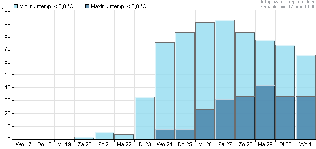
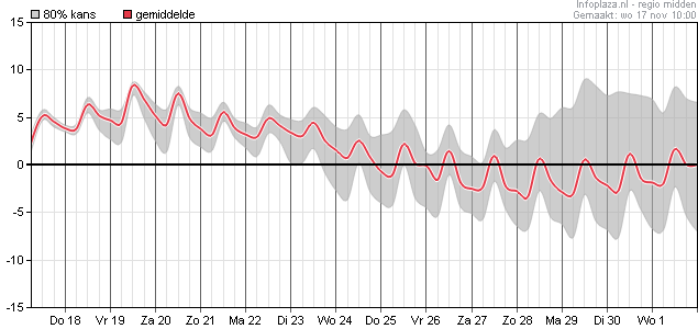
De temperatuurdaling is goed te zien op onderstaande 2 kaarten. Indrukwekkende kans op vorstdagen zo rond 25-28 november. Zelfs ijsdagen zijn niet uitgesloten. Evt. sneeuwdek moet wel weer rekening mee gehouden worden en uiteraard ook niet gecorrigeerd. Pas na de 28e vind ik het qua temperatuur uit elkaar gaan lopen, zeer logisch gezien de termijn.
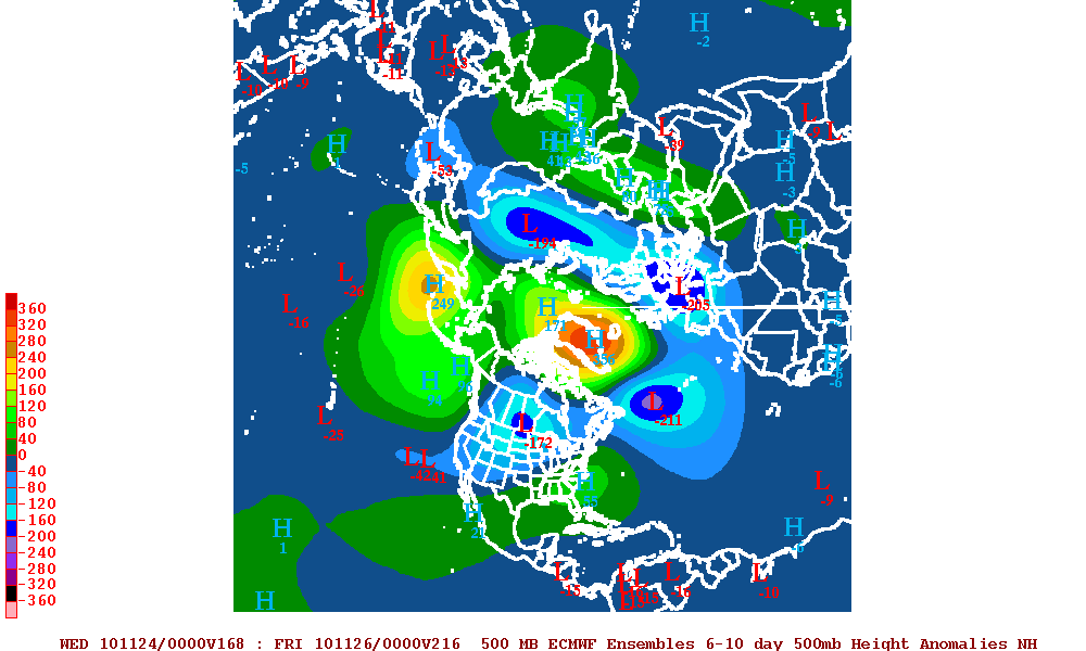
Extremely impressive day 6-10 ECM ensemble mean H5 anomaly locating the block over Greenland giving a sustained period of 850hPa air temperture values around 4-6 below normal, locally 8-10 I suspect for much of NW Europe.
Worth noting that the hemispheric pattern is being prevented from being energised in the Pacific by that large ridge over the Aleutians. With that cold puddle of air over Europe and no upstream changes likely to open out the wavelengths, we are stuck in a cold rut.
Tonight's ESRL update to angular momentum budgets will be well worth monitoring as another mountain torque event is developing which is likely to have ramifications for re-strengthening of the block in the 15-20 day timeframe, potentially a much larger one 10 days later impacting our weather around mid December.
The imapct of mountain torques, allied to the underlying low angular momentum base state suggests the reload will come from ridging in the Atlantic / trough disruption.
I see also the the wobbling around of the mean ridge position over the Arctic and potential for a west based -NAO phase which would fit those analogues for stratoshperic profiling. However, the key mover here looks to be angular momentum and how this trends in early December. Tentative signs from the SOI that a renewed trade wind surge will drop angular momentum further signalling strength for blocking in the North Atlantic.
With an east based -NAO, the core of the block is centred more towards Iceland keeping the UK and NW Europe colder than normal. Any low pressures which attempt to come in from teh Atlantic are deflected well south.
A west based -NAO is assoiciated with the core of the block over western Greenland and even Canada. This allows the jet stream to pivot in the Atlantic and work back intowards the UK.
De temperatuurdaling is goed te zien op onderstaande 2 kaarten. Indrukwekkende kans op vorstdagen zo rond 25-28 november. Zelfs ijsdagen zijn niet uitgesloten. Evt. sneeuwdek moet wel weer rekening mee gehouden worden en uiteraard ook niet gecorrigeerd. Pas na de 28e vind ik het qua temperatuur uit elkaar gaan lopen, zeer logisch gezien de termijn.
Bericht laatst bijgewerkt: 17-11-2010 12:49
„Et nul ne se connait tant qu'il n'a pas souffert, „C'est une dure loi, mais une loi suprème, „Vieille comme le monde et la fatalité, „Qu'l nous faut du malheur regevoir le baptéme, ~Et qu'a ce triste prix tout doit étre acheté. „Les moissons pour murir out besoin de rosée, „Pour vivre et pour sentir l'homme a besoin de pleura, „La joie a pour symbole une plante brisée, „Humide encore de pluie et couverte de fleurs."

