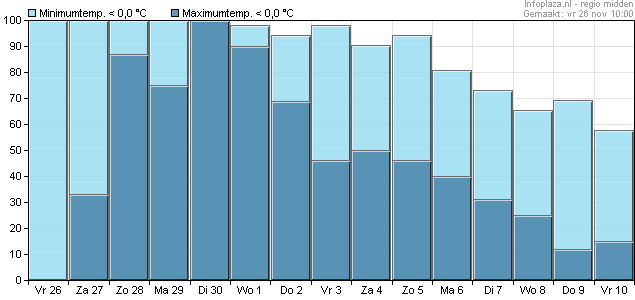
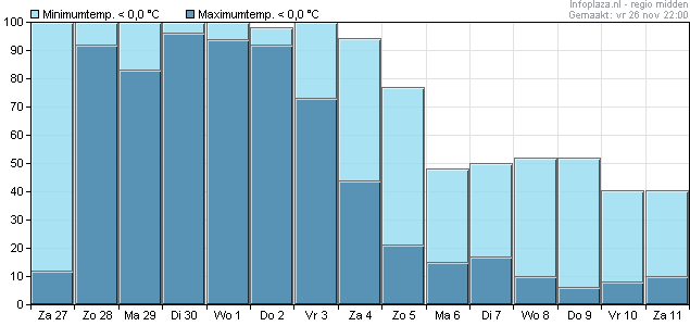
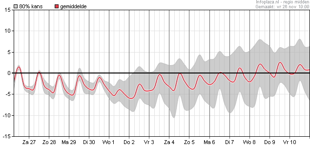
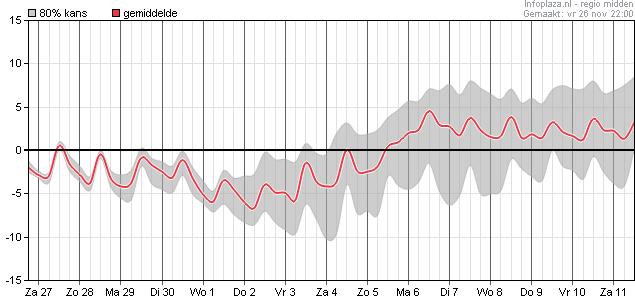
Kans op ijsdagen lijkt me volgende week erg groot. Na vrijdag lijkt het zachter te gaan worden, kans op vorst daalt naar ongeveer 50%, kans op een ijzig weertype (ijsdagen) is ongeveer 20%, flinke daling op die (zeer onzekere) termijn. Rond Sinterklaas komt het gemiddelde weer boven 0c. Woensdag en donderdag kunnen wel eens erg koude dagen worden.
Elders vond ik nog deze bijdrage, die ik wel interessant vond om te posten. Grappig dat ze in de UK ook 'onze' pluim gebruiken.
Regarding the much talked about blizzard!
Theres still the chance of frontal snow and strong winds for the south and se,this threat hasn't disappeared however the very deep low has.
Given the last few days just who knows what the next surprise will be.
Looking at the ECM De Bilt ensembles for the Netherlands is a good indicator here seeing as any low would pass through there eventually.
http://www.knmi.nl/exp/pluim/Data/PLUIM_06260_NWT.png
The operational run is towards the top end of members for the key time in terms of wind. However in these timeframes the operational runs should be better indicators.
The evenings NOAA discussions support the cold to continue.This part is the most important regarding Europe:
DURING THE WEEK 2 PERIOD, GFS AND ECMWF ENSEMBLE MEAN SOLUTIONS AGREE UPON A
PAIR OF LARGE POSITIVE 500-HPA HEIGHT ANOMALY CENTERS (MORE THAN 200 METERS) AT
THE SOUTHERN TIP OF GREENLAND AND THE WESTERN ALEUTIANS. ALTHOUGH THE GFS AND
ECMWF MODELS ARE IN GOOD AGREEMENT AT THE HIGHER LATITUDES, MODEL DISAGREEMENT
IS EVIDENT AT THE MIDDLE LATITUDES. THE GFS ENSEMBLE MEANS, FEATURING MORE
AMPLIFIED 500-HPA TROUGHS OVER THE EASTERN CONUS AND NEAR THE WEST COAST, ARE
PREFERRED TODAY.
And finally this:
http://www.cpc.ncep.noaa.gov/products/predictions/814day/500mb.php
This ties in with the teleconnections.Interestingly they prefer the GEFS mean which is more amplified, that just adds to the good news if you like the cold.
For newer members the more amplified the eastern USA trough is the better chance of a cold plunge on this side of the Atlantic probably by way of a northerly or nw flow.
Elders vond ik nog deze bijdrage, die ik wel interessant vond om te posten. Grappig dat ze in de UK ook 'onze' pluim gebruiken.
Regarding the much talked about blizzard!
Theres still the chance of frontal snow and strong winds for the south and se,this threat hasn't disappeared however the very deep low has.
Given the last few days just who knows what the next surprise will be.
Looking at the ECM De Bilt ensembles for the Netherlands is a good indicator here seeing as any low would pass through there eventually.
http://www.knmi.nl/exp/pluim/Data/PLUIM_06260_NWT.png

The operational run is towards the top end of members for the key time in terms of wind. However in these timeframes the operational runs should be better indicators.
The evenings NOAA discussions support the cold to continue.This part is the most important regarding Europe:
DURING THE WEEK 2 PERIOD, GFS AND ECMWF ENSEMBLE MEAN SOLUTIONS AGREE UPON A
PAIR OF LARGE POSITIVE 500-HPA HEIGHT ANOMALY CENTERS (MORE THAN 200 METERS) AT
THE SOUTHERN TIP OF GREENLAND AND THE WESTERN ALEUTIANS. ALTHOUGH THE GFS AND
ECMWF MODELS ARE IN GOOD AGREEMENT AT THE HIGHER LATITUDES, MODEL DISAGREEMENT
IS EVIDENT AT THE MIDDLE LATITUDES. THE GFS ENSEMBLE MEANS, FEATURING MORE
AMPLIFIED 500-HPA TROUGHS OVER THE EASTERN CONUS AND NEAR THE WEST COAST, ARE
PREFERRED TODAY.
And finally this:
http://www.cpc.ncep.noaa.gov/products/predictions/814day/500mb.php
This ties in with the teleconnections.Interestingly they prefer the GEFS mean which is more amplified, that just adds to the good news if you like the cold.
For newer members the more amplified the eastern USA trough is the better chance of a cold plunge on this side of the Atlantic probably by way of a northerly or nw flow.
Bericht laatst bijgewerkt: 26-11-2010 22:26
„Et nul ne se connait tant qu'il n'a pas souffert, „C'est une dure loi, mais une loi suprème, „Vieille comme le monde et la fatalité, „Qu'l nous faut du malheur regevoir le baptéme, ~Et qu'a ce triste prix tout doit étre acheté. „Les moissons pour murir out besoin de rosée, „Pour vivre et pour sentir l'homme a besoin de pleura, „La joie a pour symbole une plante brisée, „Humide encore de pluie et couverte de fleurs."