In de stratosfeer van de Noordpool wordt een drastische opwarming verwacht. Altijd afwachten natuurlijk of het uitkomt. Zie hieronder. De gebeurtenissen in de Pacific, Alaska, Canada waar een sterk hogedrukgebied ontstaat kunnen mijn inziens later wel voor gevolgen bij ons hebben, nl. dat de jet meer gaat meanderen. Komende tijd gaan de modellen daarnaast meer spelen, verkennen de mogelijkheid van zuidelijke uitbreidingen van het Poolhoog. Ik verwacht daar niet te veel van, aangezien er nog veel kou is en het patroon voorlopig nog vlak. Ik denk dat we richting het weekend de eerste spectaculaire kaarten gaan krijgen. Aangezien dan de gevolgen van de kou in de VS duidelijker worden.
Yesterday I suggested that the stratospheric forecasts were holding back from suggesting a SSW which I thought was likely last week. Well today, even though a SSW is not yet forecast the forecasts have taken a large step towards this. I commented that there was a second wave of warming forecast, and this looks like producing a dramatic effect on the polar vortex. Look at the temp forecast compared to yesterday :
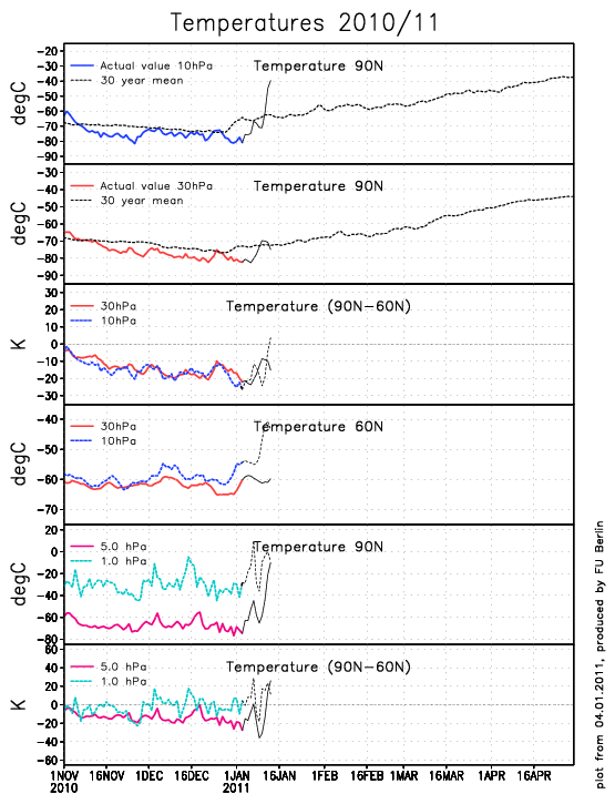
A big improvement across the board.
And now for the major step towards a SSW - the mean zonal winds for the upper stratosphere for the first time have been forecast to reverse (from +80m/s) as seen here.
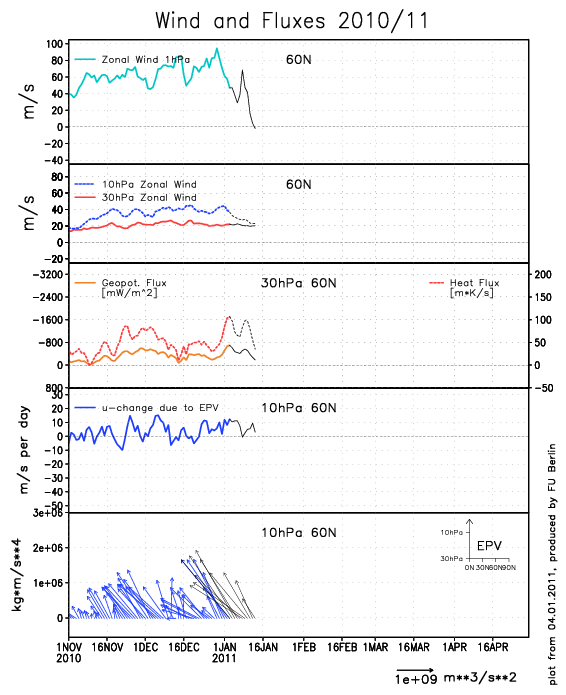
This is no mean feat and has occurred as the vortex gets displaced from the pole. This is not to say that reversal will occur throughout the whole stratosphere but we have to start somewhere.
Back down to the 100hPa layer and any displacement so far has firmly pushed the distorted vortex towards us with the blocking seen in the Pacific region, so not a whiff of an easterly on the cards until blocking can become established on our side of the hemisphere. We cannot rule out an Easterly longer term but for those wishing to base there forecasts on something more reliable than an odd ensemble member way out in FI, keep watching in here and I will be the first to let you know!
Yesterday I suggested that the stratospheric forecasts were holding back from suggesting a SSW which I thought was likely last week. Well today, even though a SSW is not yet forecast the forecasts have taken a large step towards this. I commented that there was a second wave of warming forecast, and this looks like producing a dramatic effect on the polar vortex. Look at the temp forecast compared to yesterday :
A big improvement across the board.
And now for the major step towards a SSW - the mean zonal winds for the upper stratosphere for the first time have been forecast to reverse (from +80m/s) as seen here.
This is no mean feat and has occurred as the vortex gets displaced from the pole. This is not to say that reversal will occur throughout the whole stratosphere but we have to start somewhere.
Back down to the 100hPa layer and any displacement so far has firmly pushed the distorted vortex towards us with the blocking seen in the Pacific region, so not a whiff of an easterly on the cards until blocking can become established on our side of the hemisphere. We cannot rule out an Easterly longer term but for those wishing to base there forecasts on something more reliable than an odd ensemble member way out in FI, keep watching in here and I will be the first to let you know!
Bericht laatst bijgewerkt: 04-01-2011 15:01
„Et nul ne se connait tant qu'il n'a pas souffert, „C'est une dure loi, mais une loi suprème, „Vieille comme le monde et la fatalité, „Qu'l nous faut du malheur regevoir le baptéme, ~Et qu'a ce triste prix tout doit étre acheté. „Les moissons pour murir out besoin de rosée, „Pour vivre et pour sentir l'homme a besoin de pleura, „La joie a pour symbole une plante brisée, „Humide encore de pluie et couverte de fleurs."