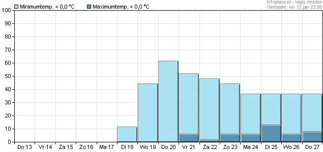
Duidelijke daling tov eerdere runs. In dat opzicht nog even afwachten of dat doorzet. Kan morgen weer anders zijn. Depressie die voor WA moet zorgen op 144-168 ligt nog uit het betrouwbare gebied, er kan nog een boel veranderen.
Mooi samengevat hieronder;
f you're a cold and snow lover you'll probably be reaching for the off button as todays output taken at face value generally paints a colder but for some a very underwhelming outlook.
The snoozometer may well be hitting high levels in the coming days if the UK ends up with a limpet high closeby.
Having said all this is the pattern shown by the models giving us an accurate picture?
Looking at the NOAA extended discussions for the medium term they do highlight alot of uncertainty in the eastern seaboard of the USA and this is going to impact on the amplitude of any mid Atlantic ridge.
The ECM at 168hrs shows a deep low about to exit the eastern USA:
http://www.meteociel.fr/modeles/ecmwf.php?ech=168&mode=1&map=1&archive=0
As you can see that ridge ahead of it,the amplitude of that low and its track will impact on that ridge.
We have been talking for the last few days about the MJO and its possible impact on the models and this has to be factored into the output, so with this background uncertainty theres still room for some changes either way.
So looking forward it's likely to turn somewhat colder but I think theres sufficient uncertainty upstream to keep our finger away from the off button for now!
Mooi samengevat hieronder;
f you're a cold and snow lover you'll probably be reaching for the off button as todays output taken at face value generally paints a colder but for some a very underwhelming outlook.
The snoozometer may well be hitting high levels in the coming days if the UK ends up with a limpet high closeby.
Having said all this is the pattern shown by the models giving us an accurate picture?
Looking at the NOAA extended discussions for the medium term they do highlight alot of uncertainty in the eastern seaboard of the USA and this is going to impact on the amplitude of any mid Atlantic ridge.
The ECM at 168hrs shows a deep low about to exit the eastern USA:
http://www.meteociel.fr/modeles/ecmwf.php?ech=168&mode=1&map=1&archive=0
As you can see that ridge ahead of it,the amplitude of that low and its track will impact on that ridge.
We have been talking for the last few days about the MJO and its possible impact on the models and this has to be factored into the output, so with this background uncertainty theres still room for some changes either way.
So looking forward it's likely to turn somewhat colder but I think theres sufficient uncertainty upstream to keep our finger away from the off button for now!
Bericht laatst bijgewerkt: 12-01-2011 22:34
„Et nul ne se connait tant qu'il n'a pas souffert, „C'est une dure loi, mais une loi suprème, „Vieille comme le monde et la fatalité, „Qu'l nous faut du malheur regevoir le baptéme, ~Et qu'a ce triste prix tout doit étre acheté. „Les moissons pour murir out besoin de rosée, „Pour vivre et pour sentir l'homme a besoin de pleura, „La joie a pour symbole une plante brisée, „Humide encore de pluie et couverte de fleurs."