'Enige' 2 kansen die ik zie dat hogedrukgebied niet boven de UK komt, maar boven het continent, waarbij we aanvoer krijgen van aanlandige wind en/of net ten noorden van ons.
Ik vond dit nog wel een aardige samenvatting. Volgens mij ook in lijn waar Torkaan in november mee kwam.
Slowly, but surely, we are beginning to see a pattern emerge that is gaining support from most angles. The pattern is one that was very much anticipated by GP before the winter started, but has not been established yet due to the extent of northern blocking seen in early winter that is only just beginning to show signs of reducing.
The reduction in northern blocking is supported by both the AO and NAO outlooks which look like going neutral first, before, I suspect turning positive.
The pattern that is gaining credence is that of the forming mid Atlantic block that is seen quite clearly on the 8-10 day mean ECN and GFS 500 hPa heights
http://www.meteo.psu.edu/~gadomski/ECMWF_12z/hgtcomp.html
So why the confidence for this type of pattern and how long is it likely to last.
Well firstly, I believe that the wet weather that we are experiencing is very much due to the transition of patterns from northern blocking to blocking further south. The increase in tropical convection leading to the large MJO wave into phase 6/7 is reinforcing the La NIna pattern.
It is no coincidence that the mid Atlantic blocking forecast is very much in line with the phase 6 MJO forecast H500 anomaly composite in a La Nina Phase.
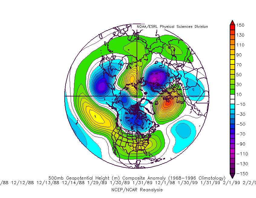
The stratospheric charts support this outcome. What we have seen forecast over the past week is the polar vortex revolve anti-clockwise around the North Pole from Siberia to Canada before settling towards the Pacific sector. This is gaining in strength as the upper warming and disturbances fail to propagate down to the troposphere. This is totally in line with the positive QBO year and therefore we are seeing no 2009 SSW after earlier threats this January.
We can see the ECM lower stratospheric charts which very much suggest a mid Atlantic high - the GFS suggests a flatter pattern.
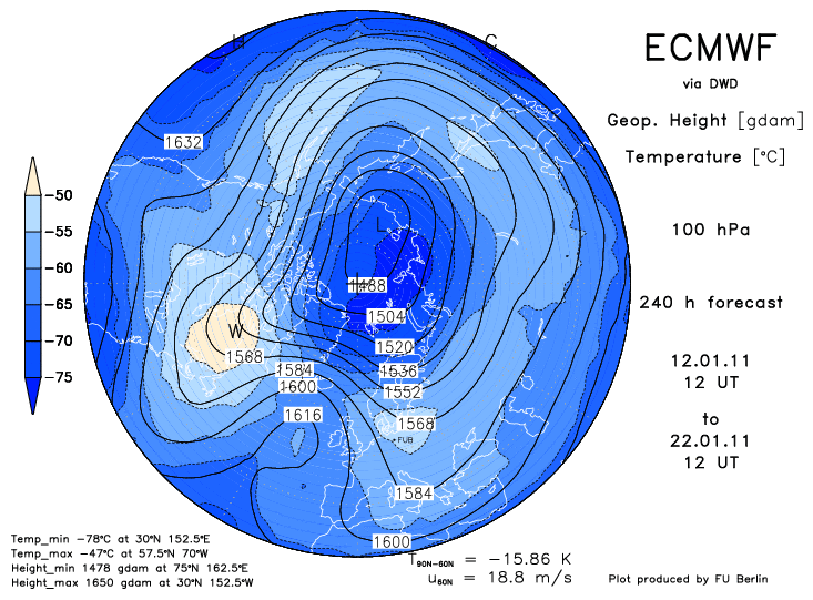
This type of pattern suggests an Atlantic toppling kind of situation with incursions of cooler polar air being mixed into the jet stream flow over the high. Depending on the exact positioning of the high will determine how much cold air can filter down around the high but I suspect temperature could fluctuate from slightly below average to around average.
Longer term, using the stratospheric profiles, I cannot at this point see any longer term return to any northern blocking. If anything , due to the lack of propagating temperature and zonal mean wind anomalies I can see only an increase in the polar vortex strength. This will drive the AO above neutral and tend to flatten any amplification in the Atlantic ridge that may be seen in the medium term.
This would support those who have suggested a milder February pattern. For those who have suggested another extreme cold spell there is the real risk that their forecast may become derailed.
http://forum.netweather.tv/topic/67899-model-output-discussion/page__st__136
Ik vond dit nog wel een aardige samenvatting. Volgens mij ook in lijn waar Torkaan in november mee kwam.
Slowly, but surely, we are beginning to see a pattern emerge that is gaining support from most angles. The pattern is one that was very much anticipated by GP before the winter started, but has not been established yet due to the extent of northern blocking seen in early winter that is only just beginning to show signs of reducing.
The reduction in northern blocking is supported by both the AO and NAO outlooks which look like going neutral first, before, I suspect turning positive.
The pattern that is gaining credence is that of the forming mid Atlantic block that is seen quite clearly on the 8-10 day mean ECN and GFS 500 hPa heights
http://www.meteo.psu.edu/~gadomski/ECMWF_12z/hgtcomp.html
So why the confidence for this type of pattern and how long is it likely to last.
Well firstly, I believe that the wet weather that we are experiencing is very much due to the transition of patterns from northern blocking to blocking further south. The increase in tropical convection leading to the large MJO wave into phase 6/7 is reinforcing the La NIna pattern.
It is no coincidence that the mid Atlantic blocking forecast is very much in line with the phase 6 MJO forecast H500 anomaly composite in a La Nina Phase.
The stratospheric charts support this outcome. What we have seen forecast over the past week is the polar vortex revolve anti-clockwise around the North Pole from Siberia to Canada before settling towards the Pacific sector. This is gaining in strength as the upper warming and disturbances fail to propagate down to the troposphere. This is totally in line with the positive QBO year and therefore we are seeing no 2009 SSW after earlier threats this January.
We can see the ECM lower stratospheric charts which very much suggest a mid Atlantic high - the GFS suggests a flatter pattern.
This type of pattern suggests an Atlantic toppling kind of situation with incursions of cooler polar air being mixed into the jet stream flow over the high. Depending on the exact positioning of the high will determine how much cold air can filter down around the high but I suspect temperature could fluctuate from slightly below average to around average.
Longer term, using the stratospheric profiles, I cannot at this point see any longer term return to any northern blocking. If anything , due to the lack of propagating temperature and zonal mean wind anomalies I can see only an increase in the polar vortex strength. This will drive the AO above neutral and tend to flatten any amplification in the Atlantic ridge that may be seen in the medium term.
This would support those who have suggested a milder February pattern. For those who have suggested another extreme cold spell there is the real risk that their forecast may become derailed.
http://forum.netweather.tv/topic/67899-model-output-discussion/page__st__136
„Et nul ne se connait tant qu'il n'a pas souffert, „C'est une dure loi, mais une loi suprème, „Vieille comme le monde et la fatalité, „Qu'l nous faut du malheur regevoir le baptéme, ~Et qu'a ce triste prix tout doit étre acheté. „Les moissons pour murir out besoin de rosée, „Pour vivre et pour sentir l'homme a besoin de pleura, „La joie a pour symbole une plante brisée, „Humide encore de pluie et couverte de fleurs."