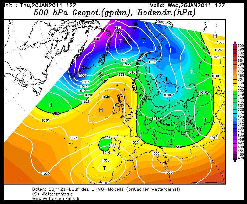
Zelfde geldt voor UKMO, we liggen zo'n beetje op de grens, last van de Noordzee en omdat de stroming onvoldoende NO of beter nog Oostelijk is. Ik denk dat we het moeten hebben van uitlopers naar Scandinavie en dat we noordelijke aanpuntingen kunnen vergeten (ik zie het in ieder geval niet terug keren in de modellen + ik vond nog een aardige beschouwing over waarom dat zo is.
Eerst een aantal punten over de stratosfeer en later waarom het hoog niet aanpunt naar het noorden.
1) stratospheric timescales are extremely slow, sometimes months for events over the tropics to impact the polar atmosphere;
2) the importance of having a handle on the mean state of the Arctic Oscillation during the core of the winter;
3) stratoshperically, the correlation between stratosphere and troposphere is greatest during the period January, February and March which is considered the height of the winter; during the autumn and early part of the winter the correlation between Arctic Oscillation and North Atlantic Oscillation is lower and tropospheric teleconnections can play a bigger role.
The last described is criticial to understanding where we are now and where we might go. During the polar outbreaks in October, November and December (note the periodicity there) we were in a very similar position with high pressure blocks setting up in the mid latitudes but soon extended northward due to a very amplified pattern and little in the way of zonal winds (polar westerlies) in the high latitudes (which is why La Ninas typically are coldest early on because of lagged -NAO tendency / weak zonal winds in the late autumn).
During January and February, the correlation between the AO and NAO is strong with the AO leading the NAO. All global model ensemble mean tools are pointing towards an organised polar vortex and polar westerlies arranged around this driving the AO positive and the NAO following the lead. We have our mid latitude block but it is unable to ridge far enough northward due to increased flow over the top. With the anomalous mid latitude ridge signal persisting for some time, and the polar vortex in place, there aren't a lot of places to go.
In terms of change, the signalling for the ridge to shift south and south-east over time and wobble bag to the UK is there from the tropics (although questionable now how much MJO forcing we are going to see beyiond phase 7 - the Global Wind Oscillation looks the more likely dominant signal to me - mid latitude ridges). In terms of the polar vortex, the only mechanisms by which this might shift would be a warming event propagating downwards, or a significanbt ridge extending from the north Pacific although this in itself could reinforce the polar vortex on our side of the hemisphere.
Bit of a photoshop job splicing yearly plots, but we can see here how the westerly winds have increased in strength from the upper stratosphere and propagated downwards. They now are impacting the 200hPa and 500hPa layers, hence polar vortex and lowering heights.

These waves are complex beasts but the general periodicity is for 3 months of upwelling (easterly downwelling) favouring high latitude blocking and 3 months downwelling westerlies destructively interferring with blocking as it interacts with the upper troposphere. The timing of this has been pretty much in line with projections. The next wave should be instigated by the change in the QBO late summer / autumn.
Eerst een aantal punten over de stratosfeer en later waarom het hoog niet aanpunt naar het noorden.
1) stratospheric timescales are extremely slow, sometimes months for events over the tropics to impact the polar atmosphere;
2) the importance of having a handle on the mean state of the Arctic Oscillation during the core of the winter;
3) stratoshperically, the correlation between stratosphere and troposphere is greatest during the period January, February and March which is considered the height of the winter; during the autumn and early part of the winter the correlation between Arctic Oscillation and North Atlantic Oscillation is lower and tropospheric teleconnections can play a bigger role.
The last described is criticial to understanding where we are now and where we might go. During the polar outbreaks in October, November and December (note the periodicity there) we were in a very similar position with high pressure blocks setting up in the mid latitudes but soon extended northward due to a very amplified pattern and little in the way of zonal winds (polar westerlies) in the high latitudes (which is why La Ninas typically are coldest early on because of lagged -NAO tendency / weak zonal winds in the late autumn).
During January and February, the correlation between the AO and NAO is strong with the AO leading the NAO. All global model ensemble mean tools are pointing towards an organised polar vortex and polar westerlies arranged around this driving the AO positive and the NAO following the lead. We have our mid latitude block but it is unable to ridge far enough northward due to increased flow over the top. With the anomalous mid latitude ridge signal persisting for some time, and the polar vortex in place, there aren't a lot of places to go.
In terms of change, the signalling for the ridge to shift south and south-east over time and wobble bag to the UK is there from the tropics (although questionable now how much MJO forcing we are going to see beyiond phase 7 - the Global Wind Oscillation looks the more likely dominant signal to me - mid latitude ridges). In terms of the polar vortex, the only mechanisms by which this might shift would be a warming event propagating downwards, or a significanbt ridge extending from the north Pacific although this in itself could reinforce the polar vortex on our side of the hemisphere.
Bit of a photoshop job splicing yearly plots, but we can see here how the westerly winds have increased in strength from the upper stratosphere and propagated downwards. They now are impacting the 200hPa and 500hPa layers, hence polar vortex and lowering heights.

These waves are complex beasts but the general periodicity is for 3 months of upwelling (easterly downwelling) favouring high latitude blocking and 3 months downwelling westerlies destructively interferring with blocking as it interacts with the upper troposphere. The timing of this has been pretty much in line with projections. The next wave should be instigated by the change in the QBO late summer / autumn.
„Et nul ne se connait tant qu'il n'a pas souffert, „C'est une dure loi, mais une loi suprème, „Vieille comme le monde et la fatalité, „Qu'l nous faut du malheur regevoir le baptéme, ~Et qu'a ce triste prix tout doit étre acheté. „Les moissons pour murir out besoin de rosée, „Pour vivre et pour sentir l'homme a besoin de pleura, „La joie a pour symbole une plante brisée, „Humide encore de pluie et couverte de fleurs."