Bij mij begint het al weer te kriebelen! zowel in me buik als in me ogen (hooikoorts)
DISCUSSION
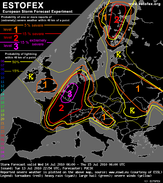
... France, Benelux, Western half of Germany ...
***Potentially dangerous setup with severe weather outbreak is forecast over this region***
Ahead of the frontal zone, high Theta-E airmass is advected at lower levels and as cooler mid-level temperatures overspread this airmass a belt of moderate latent instability is forecast to form. Models are in fairly good agreement regarding the CAPE values, which should be mostly in the range of 1000-1500 J/kg.
With strong southerly to southwesterly flow aloft, high values of wind shear are forecast, with over 25 m/s of DLS and 20 m/s of MLS, values sufficient for very well organised convection, including supercells. With weak relative upper level flow, convection will probably tend to organise into quasi-linear system rathern than into long-lived supercells. Another factor speaking for such system is the orientation of the mid and upper level flow to the boundary, which is almost parallel and therefore, quick clustering is expected. Nevertheless, the possibility of isolated, steadier supercellular convection, especially in the earlier stages of scenario can not be discounted.
Forcing should be very favorable, in the form of the cold front and as the above mentioned short wave trough , which might induce or support cyclogenesis in the axis of the frontal trough. Such low would probably contribute to the backing of the surface winds (increasing SREH values) ahead of it and to the strenghtening wind field at lower levels. Models simulate 30 m/s 700 hPa flow during evening and night hours in the proximity and behind of the surface front.
With such strong wind field at lower levels, quickly travelling mid-level short wave trough and strong tendency for storm clustering, severe quasi-linear MCS might travel at high speeds to northeast along the front and produce a swath of severe wind gusts, including some gusts over 32 m/s. This will be the prime threat and Level 3 is issued especially for the area, where the passage of severe MCS is most probable. In the earlier stages, when isolated form of convection will prevail and over the southern parts of Level 2, large hail will be a threat, especially if supercells form. In that case, hailstones over 4 cm might be observed. Especially to the northwest of the mesoscale low, excessive precipitation might occur, at the northern end of large MCS with possibility of "train effect". With high effective PW values, at least short term excessive precipitation can not be ruled out elsewhere in Level 2. Last, but not least, tornadoes might occur and more so in the environemnt with higher SREH and LLS ahead of the mesoscale low and lower LCLs during the late evening and night hours - therefore BENELUX and Northwestern Germany will probably be the region with the highest probability of tornado occurence. The fact that the convection will tend to occur mostly in linear clusters limits the potential for tornadoes.
DISCUSSION
... France, Benelux, Western half of Germany ...
***Potentially dangerous setup with severe weather outbreak is forecast over this region***
Ahead of the frontal zone, high Theta-E airmass is advected at lower levels and as cooler mid-level temperatures overspread this airmass a belt of moderate latent instability is forecast to form. Models are in fairly good agreement regarding the CAPE values, which should be mostly in the range of 1000-1500 J/kg.
With strong southerly to southwesterly flow aloft, high values of wind shear are forecast, with over 25 m/s of DLS and 20 m/s of MLS, values sufficient for very well organised convection, including supercells. With weak relative upper level flow, convection will probably tend to organise into quasi-linear system rathern than into long-lived supercells. Another factor speaking for such system is the orientation of the mid and upper level flow to the boundary, which is almost parallel and therefore, quick clustering is expected. Nevertheless, the possibility of isolated, steadier supercellular convection, especially in the earlier stages of scenario can not be discounted.
Forcing should be very favorable, in the form of the cold front and as the above mentioned short wave trough , which might induce or support cyclogenesis in the axis of the frontal trough. Such low would probably contribute to the backing of the surface winds (increasing SREH values) ahead of it and to the strenghtening wind field at lower levels. Models simulate 30 m/s 700 hPa flow during evening and night hours in the proximity and behind of the surface front.
With such strong wind field at lower levels, quickly travelling mid-level short wave trough and strong tendency for storm clustering, severe quasi-linear MCS might travel at high speeds to northeast along the front and produce a swath of severe wind gusts, including some gusts over 32 m/s. This will be the prime threat and Level 3 is issued especially for the area, where the passage of severe MCS is most probable. In the earlier stages, when isolated form of convection will prevail and over the southern parts of Level 2, large hail will be a threat, especially if supercells form. In that case, hailstones over 4 cm might be observed. Especially to the northwest of the mesoscale low, excessive precipitation might occur, at the northern end of large MCS with possibility of "train effect". With high effective PW values, at least short term excessive precipitation can not be ruled out elsewhere in Level 2. Last, but not least, tornadoes might occur and more so in the environemnt with higher SREH and LLS ahead of the mesoscale low and lower LCLs during the late evening and night hours - therefore BENELUX and Northwestern Germany will probably be the region with the highest probability of tornado occurence. The fact that the convection will tend to occur mostly in linear clusters limits the potential for tornadoes.