De opsteller van de lange termijn verwachting van Netweather gaat voor langdurig droog weer.
The longer range modelling is starting to look a lot more realistic from my perspective with a general trend towards troughing in the Atlantic and ridge developing over Europe / Scandinavia, which is consistent with where the GWO signal is right now.
A couple of observations for the dynamical ocean-atmospheric coupling for the coming months:
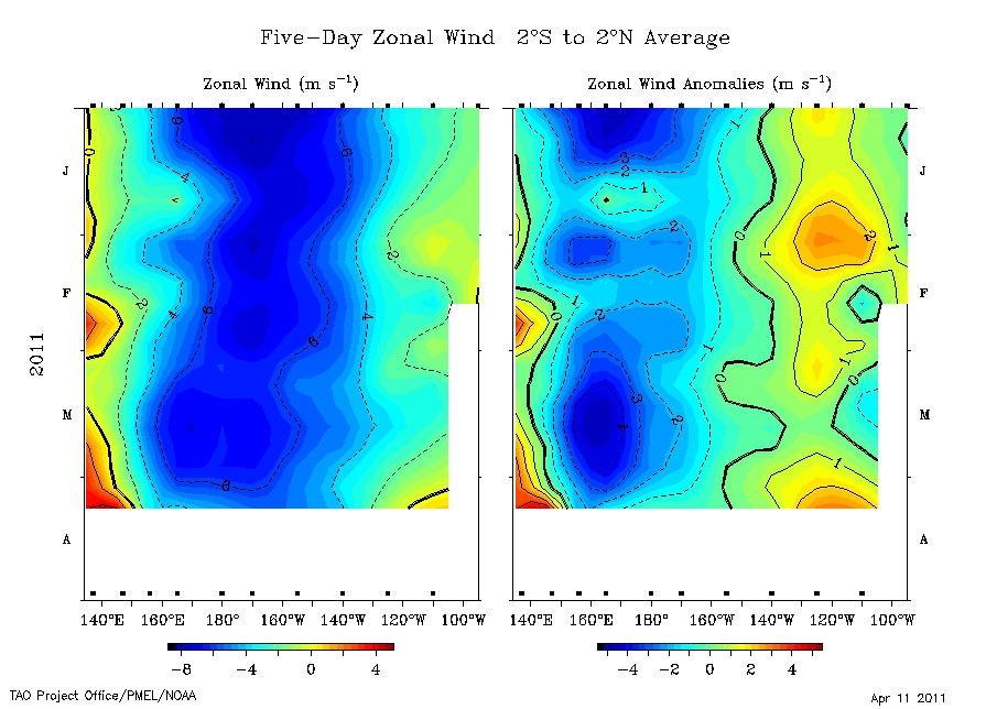
1) If we take a look at trade winds and anomalies since January, we can see that the easterly trades are at their weakest generally, second only to a brief period in January associated with a strong MJO event. In particular, take a look at the right hand side panel which shows the weakening of easterly zonal wind anomalies around the Dateline (180W). This is consistent with the atmosphere and sea surface during a decaying La Nina event (although the Southern Oscillation continues to tank positive). This increases the prospect of subsequent MJO waves to gain strength and induce further westerly wind bursts into the global system in the future. Also note how the latest westerly wind burst is the strongest this year around 140E.
Why does this matter ? It matters because westerly winds are what drive ridge development in the low and middle latitudes. More westerlyness increases the chances of high pressure for Europe into the summer.
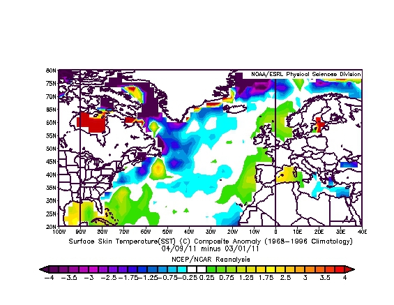
2) Analysis of the profile of SSTAs in the North Atlantic suggests that over the past month, large areas of the NW Atlantic extending up the eastern US and Canadian Coast and into the central-western sub-tropical Atlantic have cooled by 0.25C to 1C. The surface waters around the eastern Atlantic including the south-west approaches have correspondingly warmed. This is an increasing signal for troughing or cut off lows in this area as a baroclinic response with an increased probability of ridge development in the NE Atlantic and Western Europe.
Both issues raise a big question in my book. Where is summer rainfall coming from ?
Current thinking would be for May to be cooler with pressure high in the mid Atlantic, June to be nice. Not sure about the rest just yet and still working on that one although on balance we should be looking at a neutral / negative NAO and positive AO type set up with a mid latitude high pressure cell and at times the Azores ridge linking up.
http://forum.netweather.tv/topic/58354-in-depth-technical-model-discussion/page__st__799
The longer range modelling is starting to look a lot more realistic from my perspective with a general trend towards troughing in the Atlantic and ridge developing over Europe / Scandinavia, which is consistent with where the GWO signal is right now.
A couple of observations for the dynamical ocean-atmospheric coupling for the coming months:
1) If we take a look at trade winds and anomalies since January, we can see that the easterly trades are at their weakest generally, second only to a brief period in January associated with a strong MJO event. In particular, take a look at the right hand side panel which shows the weakening of easterly zonal wind anomalies around the Dateline (180W). This is consistent with the atmosphere and sea surface during a decaying La Nina event (although the Southern Oscillation continues to tank positive). This increases the prospect of subsequent MJO waves to gain strength and induce further westerly wind bursts into the global system in the future. Also note how the latest westerly wind burst is the strongest this year around 140E.
Why does this matter ? It matters because westerly winds are what drive ridge development in the low and middle latitudes. More westerlyness increases the chances of high pressure for Europe into the summer.
2) Analysis of the profile of SSTAs in the North Atlantic suggests that over the past month, large areas of the NW Atlantic extending up the eastern US and Canadian Coast and into the central-western sub-tropical Atlantic have cooled by 0.25C to 1C. The surface waters around the eastern Atlantic including the south-west approaches have correspondingly warmed. This is an increasing signal for troughing or cut off lows in this area as a baroclinic response with an increased probability of ridge development in the NE Atlantic and Western Europe.
Both issues raise a big question in my book. Where is summer rainfall coming from ?
Current thinking would be for May to be cooler with pressure high in the mid Atlantic, June to be nice. Not sure about the rest just yet and still working on that one although on balance we should be looking at a neutral / negative NAO and positive AO type set up with a mid latitude high pressure cell and at times the Azores ridge linking up.
http://forum.netweather.tv/topic/58354-in-depth-technical-model-discussion/page__st__799
„Et nul ne se connait tant qu'il n'a pas souffert, „C'est une dure loi, mais une loi suprème, „Vieille comme le monde et la fatalité, „Qu'l nous faut du malheur regevoir le baptéme, ~Et qu'a ce triste prix tout doit étre acheté. „Les moissons pour murir out besoin de rosée, „Pour vivre et pour sentir l'homme a besoin de pleura, „La joie a pour symbole une plante brisée, „Humide encore de pluie et couverte de fleurs."
