Level 1 bracht gister hoop maar veel teleurstelling, Vandaag brengt de verwachting weinig hoop en ( vul maar in)
DISCUSSION
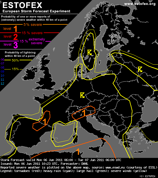
... SW Europe ... central Europe ... SE Europe ... N Mediterranean ...
The large-scale setup seems to be rather homogeneous from SW and central Europe into SE Europe and the northern and central Mediterranean.
It seems that some 500 to 1000, locally up to 1500 J/kg of MLCAPE will exist in an essentially uncapped air mass in the afternoon hours.
Though there is no focus for large-scale ascent, outflow boundaries and orography will likely initiate thunderstorms in the early afternoon
hours. Given a lack of vertical shear, storms should remain disorganized, limiting the severe-weather threat. However ... storms may congeal
into larger clusters towards the evening hours, which may locally/briefly result in a marginal hail and severe-wind threat. Given slow storm
motions, locally excessive rainfall may occur. The average severe threat across this large area seems to be too small for a categorical
risk ... however, a few regions can be highlighted where the threat is slightly enhanced:
DISCUSSION
... SW Europe ... central Europe ... SE Europe ... N Mediterranean ...
The large-scale setup seems to be rather homogeneous from SW and central Europe into SE Europe and the northern and central Mediterranean.
It seems that some 500 to 1000, locally up to 1500 J/kg of MLCAPE will exist in an essentially uncapped air mass in the afternoon hours.
Though there is no focus for large-scale ascent, outflow boundaries and orography will likely initiate thunderstorms in the early afternoon
hours. Given a lack of vertical shear, storms should remain disorganized, limiting the severe-weather threat. However ... storms may congeal
into larger clusters towards the evening hours, which may locally/briefly result in a marginal hail and severe-wind threat. Given slow storm
motions, locally excessive rainfall may occur. The average severe threat across this large area seems to be too small for a categorical
risk ... however, a few regions can be highlighted where the threat is slightly enhanced:
Bericht laatst bijgewerkt: 06-06-2011 14:13