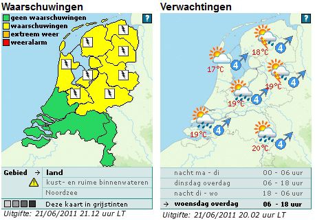
Bij buien kans op onweer Geldig: woensdag 22 juni 2011 vanaf ca 14 uur gedurende ca 5 uur
"Woensdag overdag is er vrij veel bewolking en in de ochtend maakt vooral het zuidoosten kans op enige regen. In de middag ontstaan er enkele buien. Daarbij kan onweer voorkomen en windstoten tot 65 km/uur. De buien trekken naar het noordoosten weg waarna het eind van de middag vanuit zuiden flink gaat opklaren. De temperatuur loopt op naar 17 graden langs de kust tot 20 graden landinwaarts. De zuidwestelijke wind is matig boven land en af en toe krachtig langs de kust.(bron: KNMI)"
"A level 1 was issued for NE/central Germany mainly for severe to damaging wind gusts, large hail and a few tornado events, probably transitioning into a severe wind gust and heavy rainfall risk over W-Poland and the Czech Republic."
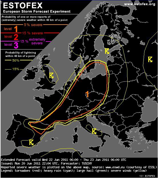
"Overall model consistency is adequate for mentioning a potential severe thunderstorm outbreak over parts of Germany, W-Poland and the Czech Republic, including severe to damaging wind gusts, large hail and a few tornado events.
ECMWF, CMC, NOGAPS and GFS all show a rapidly northeastward moving vorticity lobe, which crosses NW-Germany during the afternoon and Denmark during the early night hours from the SW. Favorable placement of a pronounced left exit region of a strong mid-level jet assists in an augmented surface pressure fall in the warm sector and hence the potential development of an extensive N-S aligned surface "pressure channel" over Germany, moving rapidly to the northeast. Hence, we expect various forcing foci, which allow scattered to widespread thunderstorm initiation within highlighted areas.
Same story as in the past when concentrating on thermodynamics with GFS being more bullish than ECMWF. Surface dewpoints in the mid-tens sound reasonable, given persistent influx of moist air from the E-Atlantic and the W-Mediterranean, so we will stick with ECMWF, expecting roughly 500 J/kg MLCAPE over N-Germany, increasing to 1000 J/kg further to the south and east (as first good EML of the season advects to S-Germany).
Kinematics look supportive for organized convection although exact strength heavily depends on the final development of the surface depression/low "pressure channel", especially with respect to any enhanced directional shear. WRF/GFS indicate an highly sheared environment, as 30 m/s speed max moves in from the SW, increasing 0-6 km DLS to roughly 25 m/s and somewhat weaker values in the lowest 3 km. If strength of surface features (seen in latest model data) remains in place, the unstable warm sector would see a favorable helical environment for supercells with an enhanced tornado risk to the north and large to isolated very large hail further to the south and east. However, the main hazard right now looks like to be bowing structures over central/N- Germany with concentrated shear within the lowest 3 km. Swaths of severe to damaging wind gusts would accompany that activity
Reasoning for not yet upgrading to a level 2 are the uncertainty about final CAPE over N/NE Germany, potential ongoing thunderstorm activity from the night before and also the final extent of the LL depression/wave over N-Germany (influencing LL speed/directional shear and the final tornado risk).
Probably numerous large thunderstorm clusters will affect W-Poland and the Czech Republic during the evening/night hours. Despite weakening CAPE, severe wind gusts and heavy rainfall are forecast well into the night."
Meteoconsult:
"Morgen is het in het oosten bewolkt met in de gebieden tegen de Duitse grens een beetje regen of motregen. In de rest van het land is het eerst droog met af en toe zon. Tegen de avond volgt overal een enkele bui, mogelijk met onweer."
"Woensdag overdag is er vrij veel bewolking en in de ochtend maakt vooral het zuidoosten kans op enige regen. In de middag ontstaan er enkele buien. Daarbij kan onweer voorkomen en windstoten tot 65 km/uur. De buien trekken naar het noordoosten weg waarna het eind van de middag vanuit zuiden flink gaat opklaren. De temperatuur loopt op naar 17 graden langs de kust tot 20 graden landinwaarts. De zuidwestelijke wind is matig boven land en af en toe krachtig langs de kust.(bron: KNMI)"
"A level 1 was issued for NE/central Germany mainly for severe to damaging wind gusts, large hail and a few tornado events, probably transitioning into a severe wind gust and heavy rainfall risk over W-Poland and the Czech Republic."
"Overall model consistency is adequate for mentioning a potential severe thunderstorm outbreak over parts of Germany, W-Poland and the Czech Republic, including severe to damaging wind gusts, large hail and a few tornado events.
ECMWF, CMC, NOGAPS and GFS all show a rapidly northeastward moving vorticity lobe, which crosses NW-Germany during the afternoon and Denmark during the early night hours from the SW. Favorable placement of a pronounced left exit region of a strong mid-level jet assists in an augmented surface pressure fall in the warm sector and hence the potential development of an extensive N-S aligned surface "pressure channel" over Germany, moving rapidly to the northeast. Hence, we expect various forcing foci, which allow scattered to widespread thunderstorm initiation within highlighted areas.
Same story as in the past when concentrating on thermodynamics with GFS being more bullish than ECMWF. Surface dewpoints in the mid-tens sound reasonable, given persistent influx of moist air from the E-Atlantic and the W-Mediterranean, so we will stick with ECMWF, expecting roughly 500 J/kg MLCAPE over N-Germany, increasing to 1000 J/kg further to the south and east (as first good EML of the season advects to S-Germany).
Kinematics look supportive for organized convection although exact strength heavily depends on the final development of the surface depression/low "pressure channel", especially with respect to any enhanced directional shear. WRF/GFS indicate an highly sheared environment, as 30 m/s speed max moves in from the SW, increasing 0-6 km DLS to roughly 25 m/s and somewhat weaker values in the lowest 3 km. If strength of surface features (seen in latest model data) remains in place, the unstable warm sector would see a favorable helical environment for supercells with an enhanced tornado risk to the north and large to isolated very large hail further to the south and east. However, the main hazard right now looks like to be bowing structures over central/N- Germany with concentrated shear within the lowest 3 km. Swaths of severe to damaging wind gusts would accompany that activity
Reasoning for not yet upgrading to a level 2 are the uncertainty about final CAPE over N/NE Germany, potential ongoing thunderstorm activity from the night before and also the final extent of the LL depression/wave over N-Germany (influencing LL speed/directional shear and the final tornado risk).
Probably numerous large thunderstorm clusters will affect W-Poland and the Czech Republic during the evening/night hours. Despite weakening CAPE, severe wind gusts and heavy rainfall are forecast well into the night."
Meteoconsult:
"Morgen is het in het oosten bewolkt met in de gebieden tegen de Duitse grens een beetje regen of motregen. In de rest van het land is het eerst droog met af en toe zon. Tegen de avond volgt overal een enkele bui, mogelijk met onweer."
Bericht laatst bijgewerkt: 21-06-2011 21:30