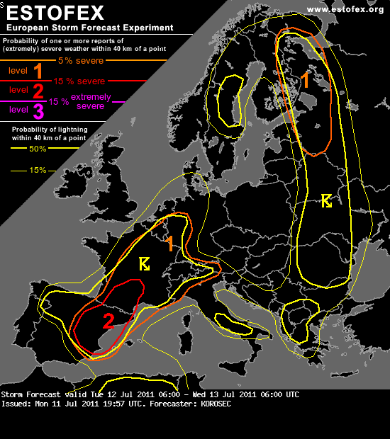
De extended forecast voor woensdag/donderdag staat ook online. Hier de verwachting voor dinsdag/woensdag:
... CNTRL France into W Germany ...
Another focus for rather robust severe storms exists along the slowly N-wards advecting warm front, extending from a SFC low in W-CNTRL France into W Germany. Placed under a strong mid-level jet, rich BL moisture results in moderate instability in the afternoon hours. GFS model is indeed again overestimating BL dewpoints and instability (Tds near 22-23°C / SBCAPE 3000 J/kg or more) while ECMWF seems more reasonable with around 1000 J/kg MLCAPE / 16-18°C SFC dewpoints. Backed flow near the warm front provides sufficient LL shear/SREH to support rotating updrafts. Storms initiation is mostly expected along the frontal convergence in mid/late afternoon hours. Favorable dynamics and kinematics should result in scattered multi and supercellular storms with threat for very large hail and damaging winds. Tornadoes could be possible as well, but this threat seems a bit limited with rather high dewpoint depression and meager wind field. Though, it improves in the evening when LLJ slightly intensifies. Storms should cluster into large MCS towards the evening, trailing NE-wards from NE France into NW Germany. A broken line with bowing segments could bring severe wind gusts and large hail.
However, conditions will be closely monitored for a possible upgrade into level 2 over these areas, especially if moisture field improves significantly on the morning SFC observations.
... CNTRL France into W Germany ...
Another focus for rather robust severe storms exists along the slowly N-wards advecting warm front, extending from a SFC low in W-CNTRL France into W Germany. Placed under a strong mid-level jet, rich BL moisture results in moderate instability in the afternoon hours. GFS model is indeed again overestimating BL dewpoints and instability (Tds near 22-23°C / SBCAPE 3000 J/kg or more) while ECMWF seems more reasonable with around 1000 J/kg MLCAPE / 16-18°C SFC dewpoints. Backed flow near the warm front provides sufficient LL shear/SREH to support rotating updrafts. Storms initiation is mostly expected along the frontal convergence in mid/late afternoon hours. Favorable dynamics and kinematics should result in scattered multi and supercellular storms with threat for very large hail and damaging winds. Tornadoes could be possible as well, but this threat seems a bit limited with rather high dewpoint depression and meager wind field. Though, it improves in the evening when LLJ slightly intensifies. Storms should cluster into large MCS towards the evening, trailing NE-wards from NE France into NW Germany. A broken line with bowing segments could bring severe wind gusts and large hail.
However, conditions will be closely monitored for a possible upgrade into level 2 over these areas, especially if moisture field improves significantly on the morning SFC observations.