Storm Forecast
Valid: Sat 03 Sep 2011 06:00 to Sun 04 Sep 2011 06:00 UTC
Issued: Sat 03 Sep 2011 01:13
Forecaster: VAN DER VELDE
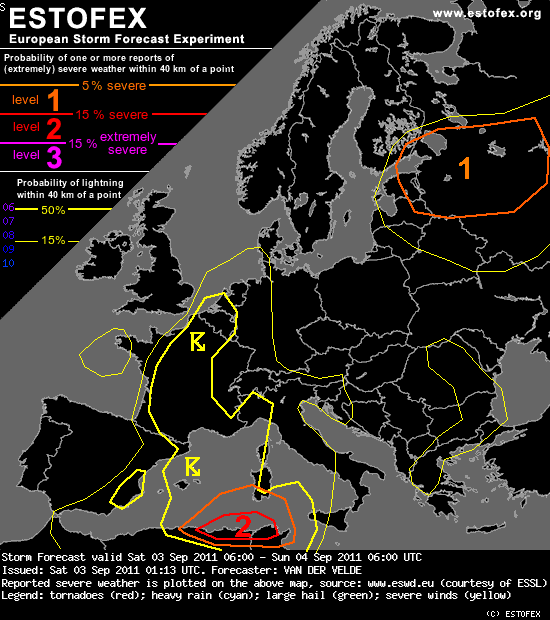
A level 2 was issued for northern Algeria and Tunisia mainly for large hail and severe convective wind gusts.
A level 1 was issued for western Russia, parts of Finland, Estonia and Latvia mainly for local excessive convective precipitation and for spout-type tornadoes.
SYNOPSIS
Between a ridge over central Europe and a trough over western Europe a southerly flow advects warm and unstable airmass northward. Widespread thunderstorms can develop. A depression and upper cut-off low over Spain push a sharpening cold front into the western Mediterranean, where airmass contains 1000-2000 J/kg CAPE.
DISCUSSION
[...]
... Spain, France, Belgium/Netherlands ...
Heavy rain may occur near the coastlines of northeastern Spain and southern France (orographic lifting and convection), as well as in northern France, western Belgium/Netherlands (convection in very humid environment with large precipitable water content and relatively slow storm motion, particularly during the night). No levels were issued for these because persistent occurrence of storms seems low, forcing seems rather weak, and mesoscale models do not produce that much rain (more typically 20-50mm).
Valid: Sat 03 Sep 2011 06:00 to Sun 04 Sep 2011 06:00 UTC
Issued: Sat 03 Sep 2011 01:13
Forecaster: VAN DER VELDE
A level 2 was issued for northern Algeria and Tunisia mainly for large hail and severe convective wind gusts.
A level 1 was issued for western Russia, parts of Finland, Estonia and Latvia mainly for local excessive convective precipitation and for spout-type tornadoes.
SYNOPSIS
Between a ridge over central Europe and a trough over western Europe a southerly flow advects warm and unstable airmass northward. Widespread thunderstorms can develop. A depression and upper cut-off low over Spain push a sharpening cold front into the western Mediterranean, where airmass contains 1000-2000 J/kg CAPE.
DISCUSSION
[...]
... Spain, France, Belgium/Netherlands ...
Heavy rain may occur near the coastlines of northeastern Spain and southern France (orographic lifting and convection), as well as in northern France, western Belgium/Netherlands (convection in very humid environment with large precipitable water content and relatively slow storm motion, particularly during the night). No levels were issued for these because persistent occurrence of storms seems low, forcing seems rather weak, and mesoscale models do not produce that much rain (more typically 20-50mm).