Betreffende een discussie die enkele dagen geleden gevoerd
Bericht van: Wouter (Mol) , 03-09-2011 15:38
werd over de afkoelende zeewatertemperatuur bij passage Irene. Vraag was of dit door menging of door gebruik van warmte door Irene was. Het antwoord blijkt duidelijk uit de prent die ik hier beneden post. De discussie die erbij hoort plak ik hier even:
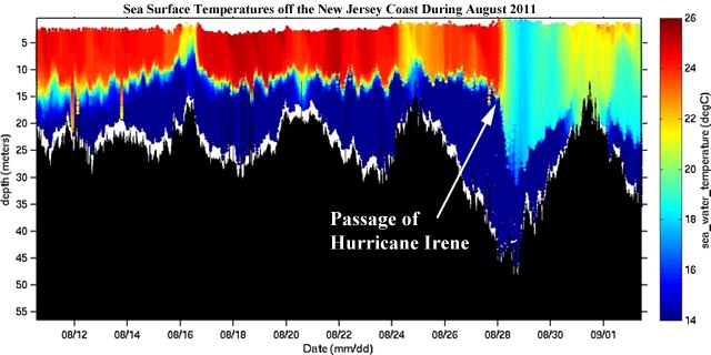
Figure 3. EPA, in conjunction with Rutgers University and the NJ Department of Environmental Protection, has an Autonomous Underwater Vehicle (AUV, aka the Glider) deployed off the coast of NJ (since early August) continuously monitoring ocean temperature, density, salinity, sound velocity and dissolved oxygen at different depths. The AUV's path and data are displayed at the following website: http://marine.rutgers.edu/cool/auvs/index.php?did =221&view=imagery. The plot of temperature versus time above shows that in the weeks prior to the arrival of Irene, the ocean was heavily stratified, with warm waters of 24 - 26°C (75 - 79°F, red colors) extending from the surface to a depth of 10 - 15 meters. A sharp thermocline existed at a depth of about 15 meters, and ocean temperatures were colder than 14°C (57°F, dark blue colors) below the thermocline. The strong winds and high wave action of Hurricane Irene on August 28 - 29 stirred up cold water from the depths to the surface, cooling the surface waters to 17 - 19°C (63 - 67°F). In the days since the hurricane, surface waters have begun to warm again. Thanks go to Kevin Kubik, Deputy Director of the Division of Environmental Science and Assessment for EPA Region 2, for making me aware of this data.
Kortom: het antwoord is duidelijk: menging!
Figure 3. EPA, in conjunction with Rutgers University and the NJ Department of Environmental Protection, has an Autonomous Underwater Vehicle (AUV, aka the Glider) deployed off the coast of NJ (since early August) continuously monitoring ocean temperature, density, salinity, sound velocity and dissolved oxygen at different depths. The AUV's path and data are displayed at the following website: http://marine.rutgers.edu/cool/auvs/index.php?did =221&view=imagery. The plot of temperature versus time above shows that in the weeks prior to the arrival of Irene, the ocean was heavily stratified, with warm waters of 24 - 26°C (75 - 79°F, red colors) extending from the surface to a depth of 10 - 15 meters. A sharp thermocline existed at a depth of about 15 meters, and ocean temperatures were colder than 14°C (57°F, dark blue colors) below the thermocline. The strong winds and high wave action of Hurricane Irene on August 28 - 29 stirred up cold water from the depths to the surface, cooling the surface waters to 17 - 19°C (63 - 67°F). In the days since the hurricane, surface waters have begun to warm again. Thanks go to Kevin Kubik, Deputy Director of the Division of Environmental Science and Assessment for EPA Region 2, for making me aware of this data.
Kortom: het antwoord is duidelijk: menging!