Joe B. verwacht koude 1e helft van de winter West Europa
Bericht van: sebastiaan (bussum) , 28-09-2011 11:41
Als het goed is komt er vandaag nog een uitgebreide 'outlook' van de winter 2012.
http://icecap.us/images/uploads/La_Nina_Reprise_Implications_on_Upcoming_Winter_Globally.pdf
La Nina’s Reprise has important implications globally
By Joe Bastardi and Joe D’Aleo, WeatherBell Analytics
Since the inception of Weatherbell last winter, we warned the ‘super’ La Nina of 2010/11 would have major implications. We focused correctly weeks to months in advance on the potential of strong tornado outbreaks, devastating flooding from late snowmelt and heavy rain in the central states, growing drought and heat in Texas and an impact hurricane season with east coast and Gulf coast landfalls likely.
Weatherbell also predicted that the La Nina would weaken but return for a second winter. This was based on a cold Pacific Decadal Oscillation which usually means La Ninas last two years or more. NOAA came onboard to this thinking in making the La Nina return official in August.
Weatherbell sees the impact of this return La Nina will be again global in nature and significant. Another harsh winter is expected in China and at least the first half of the winter in North America and Western Europe. More heavy snow will accompany the cold as our outlook will show next week
With widespread cooling, WeatherBell Analytics Meteorologists Joe Bastardi and Joe D Aleo are predicting the global temperature, which has average near 0.2C above normal this year after being over 0.4C above normal last year, will drop to near -0.15C BELOW by March. This is similar to what we saw in 2008. This will mean the yearly cooling trend, off the warm year of 2010, which is underway now, will continue in 2012, which is liable to be the coolest year since the late 1990s.
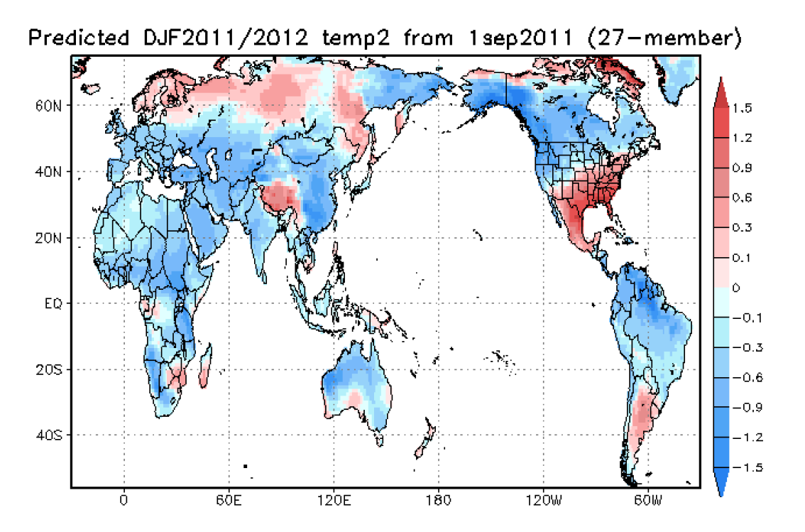
Computer modeling is now starting to see this. The JAMSTEC Frontier model captures the cooling for both hemispheres this December to February. Most of that southeast United States warmth would come in late winter.
The model shows cooling of the Atlantic to the cold mode, at least temporarily, is likely over the coming 6-9 months following the cooling of the Pacific. The drop is already starting with September. It is likely to be 0.1 to 0.2C cooler than August, which read 0.33C above.
This upcoming ocean cooling can be seen in the same Frontier Model. It shows in addition to the horseshoe of cold water surrounding the central Pacific Kuroshio current warm plume characteristic of the cold PDO that the Atlantic will have cooled and the Atlantic Multidecadal Oscillation would turn negative again as it did in early 2009. This would result in a global temperature decline.
The recent warming in the satellite era can be tied to first the warm PDO and dominance of El Ninos from 1977 to 1998 and then a step warming after 1995 when the Atlantic warm mode ensued. The Pacific has cooled with 7 La Ninas now since 1999 which has flattened the warming. A cooling of the Atlantic would result in a global cooling.
We want to continue to demonstrate to the public that the cyclical events of the global climate and the associated extremes are tied into well established natural causes and importantly PREDICTABLE. As we have with the extreme events of this past year, we trust the forecast of this before the fact, rather than explaining after will make this point once again. The last AMO warm phase lasted about 20 years, so the return to the cold Atlantic and global cooling is likely to occur this decade even if this is another temporary change.
Weatherbell has had a US winter outlook since June 1, which many are now mimicking and the latest NOAA forecast is remarkably similar too. A more detailed outlook will be out September 28, but we are available for worldwide ideas. Also as we have outlooks also for Europe and the far east where major impacts are forecast.
The bottom line is a global temperature drop is coming to the coldest levels in at least
several years, and there are winter implications that if you get the jump on, may be of benefit to you
http://weatherbell.
http://icecap.us/images/uploads/La_Nina_Reprise_Implications_on_Upcoming_Winter_Globally.pdf
La Nina’s Reprise has important implications globally
By Joe Bastardi and Joe D’Aleo, WeatherBell Analytics
Since the inception of Weatherbell last winter, we warned the ‘super’ La Nina of 2010/11 would have major implications. We focused correctly weeks to months in advance on the potential of strong tornado outbreaks, devastating flooding from late snowmelt and heavy rain in the central states, growing drought and heat in Texas and an impact hurricane season with east coast and Gulf coast landfalls likely.
Weatherbell also predicted that the La Nina would weaken but return for a second winter. This was based on a cold Pacific Decadal Oscillation which usually means La Ninas last two years or more. NOAA came onboard to this thinking in making the La Nina return official in August.
Weatherbell sees the impact of this return La Nina will be again global in nature and significant. Another harsh winter is expected in China and at least the first half of the winter in North America and Western Europe. More heavy snow will accompany the cold as our outlook will show next week
With widespread cooling, WeatherBell Analytics Meteorologists Joe Bastardi and Joe D Aleo are predicting the global temperature, which has average near 0.2C above normal this year after being over 0.4C above normal last year, will drop to near -0.15C BELOW by March. This is similar to what we saw in 2008. This will mean the yearly cooling trend, off the warm year of 2010, which is underway now, will continue in 2012, which is liable to be the coolest year since the late 1990s.
Computer modeling is now starting to see this. The JAMSTEC Frontier model captures the cooling for both hemispheres this December to February. Most of that southeast United States warmth would come in late winter.
The model shows cooling of the Atlantic to the cold mode, at least temporarily, is likely over the coming 6-9 months following the cooling of the Pacific. The drop is already starting with September. It is likely to be 0.1 to 0.2C cooler than August, which read 0.33C above.
This upcoming ocean cooling can be seen in the same Frontier Model. It shows in addition to the horseshoe of cold water surrounding the central Pacific Kuroshio current warm plume characteristic of the cold PDO that the Atlantic will have cooled and the Atlantic Multidecadal Oscillation would turn negative again as it did in early 2009. This would result in a global temperature decline.
The recent warming in the satellite era can be tied to first the warm PDO and dominance of El Ninos from 1977 to 1998 and then a step warming after 1995 when the Atlantic warm mode ensued. The Pacific has cooled with 7 La Ninas now since 1999 which has flattened the warming. A cooling of the Atlantic would result in a global cooling.
We want to continue to demonstrate to the public that the cyclical events of the global climate and the associated extremes are tied into well established natural causes and importantly PREDICTABLE. As we have with the extreme events of this past year, we trust the forecast of this before the fact, rather than explaining after will make this point once again. The last AMO warm phase lasted about 20 years, so the return to the cold Atlantic and global cooling is likely to occur this decade even if this is another temporary change.
Weatherbell has had a US winter outlook since June 1, which many are now mimicking and the latest NOAA forecast is remarkably similar too. A more detailed outlook will be out September 28, but we are available for worldwide ideas. Also as we have outlooks also for Europe and the far east where major impacts are forecast.
The bottom line is a global temperature drop is coming to the coldest levels in at least
several years, and there are winter implications that if you get the jump on, may be of benefit to you
http://weatherbell.
Bericht laatst bijgewerkt: 28-09-2011 11:48
„Et nul ne se connait tant qu'il n'a pas souffert, „C'est une dure loi, mais une loi suprème, „Vieille comme le monde et la fatalité, „Qu'l nous faut du malheur regevoir le baptéme, ~Et qu'a ce triste prix tout doit étre acheté. „Les moissons pour murir out besoin de rosée, „Pour vivre et pour sentir l'homme a besoin de pleura, „La joie a pour symbole une plante brisée, „Humide encore de pluie et couverte de fleurs."