Edit: nog een 2e bijdrage gevonden (van gisteren)
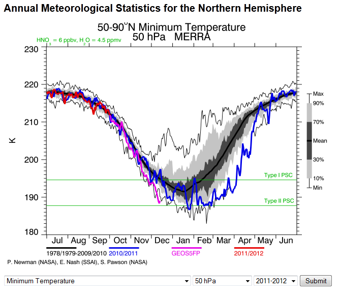
Huidige situatie. Duidelijk te zien dat het zeer koud is, zelfs record lage waarden! Sinds half november zitten we aan de onderkant van de reeks.
Elders vond ik deze interessante bijdrage.
Van gisteren
There are different types of SSW's and stratospheric warming events. The early winter 2009/2010 blocking was in response to 'local' wave breaking. That is when waves from the troposphere enter the stratosphere through the centre of the polar vortex. I believe that this is more likely if the stratospheric vortex is weak to start with. At the time the vortex split upwards from the troposphere into the middle stratosphere and this was seen well with the charts at the time.
This is completely different to 'remote' wave breaking. The forecast warming of the stratosphere is a good example of remote wave breaking. This is caused by deflected planetary wave riding the stratospheric surf zone up to the top of the stratosphere before breaking downwards trying to break into the centre of the vortex and causing the entailing disruption.
Currently we are seeing a series of waves trying to 'remotely' break into the vortex.
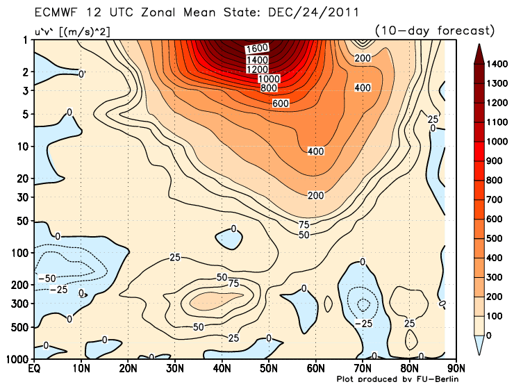
A look at the increased momentum flux forecast - this has rocketed over the last few days
These waves appear to be forecast to be successfully breaking into the vortex at the 1 hPa level. Note that the temperature charts are not the same as the potential vorticity or polar vortex geopotential height charts.
The warming at the 1 hPa chart appears to be forecast to propagate down to the mid stratosphere according to the GFS but less so according to the ECM. So far we are led to believe that there will be some pressure on the vortex but will that be enough to create a SSW?
Well, at present we do not know. There has been a lot of talk of a SSW in January this year and that is still my bet. My thoughts are that we are in an interesting tropospheric / stratospheric feedback period each wave that 'knocks' the stratospheric vortex feeds back to the troposphere leading to another stronger wave to knock again and so on and so forth until we see a SSW and a more meridional troposphere flow pattern.
The ECM charts ( which are from the previous days 12Z run) tomorrow morning (refereert naar vandaag! zie volgende bericht) will be important to see how the ECM is forecasting the projected warming. My guess is that the vortex will take a severe knock but not enough to cause a SSW, but these are very difficult to predict accurately.
However the current projected warming will already have consequences on this seasons strong vortex reducing the strength and leading to weakened jet stream. With the ozone levels rising, the residual westerly QBO flushed out, I think we will have seen the worst of the strong zonal conditions before the month of December is out and the AO will start dropping as we enter the New Year.
Bericht van vandaag
For the first time this winter we are about to see the stratosphere taking a big hit with remote wave breaking over the top of the stratosphere. It would be interesting to see the latest MT readings. Are we seeing a resurgent MT event deflecting these wave? (hij refereert naar afwijkingen die worden veroorzaakt door bergen, ik vermoed dat hij Aziatische bergen bedoelt)
Here is the momentum flux forecast for both waves - very strong activity seen here propagating into the mid stratosphere.
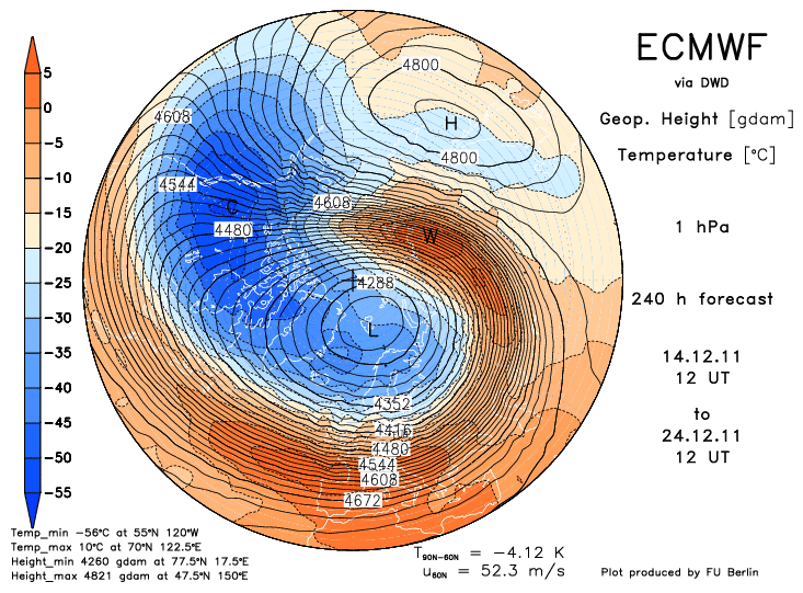
So how does this effect the polar vortex? Well the wave introduces warmer air into the vortex. The edge of the vortex is known as the surf zone and to cause maximum disruption we would like to see the warmer penetrate this strong barrier. And when we look at the 1 hPa chart right at the top of the stratosphere we see exactly that occuring.
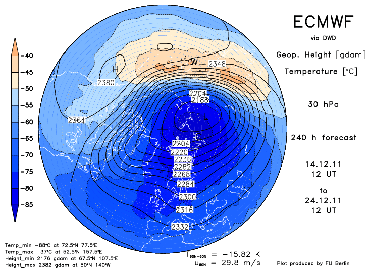
This is important because getting the warm air right inside the vortex will squeeze the colder air out, mix and cause a reduction of the vortex strength. However this is right at the top of the stratsophere and to benefit tropospherically from this we need to see the same ocuring at lower levels. Today at the 30 hPa we are seeing signs that this is occurring.
Now this presently is not enough to cause a SSW - we would need to see far greater warming for this ( but can't rule out that happening from this wave either). But it is enough to cause a displacement of the vortex.
And if this forecast comes to fruition then we will have far more to look forward to coming into the new year as further waves feed back into the stratosphere. With a reduction of the vortex for the first time this winter the door would be opening for northern blocking to occur. (GFS kwam al eerder met opwarming, EC lijkt nu te gaan volgen. Opvallend lijkt dat GFS dit aspect vaak beter (en eerder) in de smiezen heeft dan EC).
I am thinking of a transitional period between zonality and heights building to our Ne starting in the last third of the month. This transitional period is likely to be slow - the polar vortex is not suddenly going to reduce overnight as if switched off. Very dependent as well on upper profile vortex positions.
Very much compare to a changing tide, at first only one or two waves may reach you, but after a while it is only one or two that don't reach you. The change of zonal conditions to our NE will probably be like that.
Huidige situatie. Duidelijk te zien dat het zeer koud is, zelfs record lage waarden! Sinds half november zitten we aan de onderkant van de reeks.
Elders vond ik deze interessante bijdrage.
Van gisteren
There are different types of SSW's and stratospheric warming events. The early winter 2009/2010 blocking was in response to 'local' wave breaking. That is when waves from the troposphere enter the stratosphere through the centre of the polar vortex. I believe that this is more likely if the stratospheric vortex is weak to start with. At the time the vortex split upwards from the troposphere into the middle stratosphere and this was seen well with the charts at the time.
This is completely different to 'remote' wave breaking. The forecast warming of the stratosphere is a good example of remote wave breaking. This is caused by deflected planetary wave riding the stratospheric surf zone up to the top of the stratosphere before breaking downwards trying to break into the centre of the vortex and causing the entailing disruption.
Currently we are seeing a series of waves trying to 'remotely' break into the vortex.
A look at the increased momentum flux forecast - this has rocketed over the last few days
These waves appear to be forecast to be successfully breaking into the vortex at the 1 hPa level. Note that the temperature charts are not the same as the potential vorticity or polar vortex geopotential height charts.
The warming at the 1 hPa chart appears to be forecast to propagate down to the mid stratosphere according to the GFS but less so according to the ECM. So far we are led to believe that there will be some pressure on the vortex but will that be enough to create a SSW?
Well, at present we do not know. There has been a lot of talk of a SSW in January this year and that is still my bet. My thoughts are that we are in an interesting tropospheric / stratospheric feedback period each wave that 'knocks' the stratospheric vortex feeds back to the troposphere leading to another stronger wave to knock again and so on and so forth until we see a SSW and a more meridional troposphere flow pattern.
The ECM charts ( which are from the previous days 12Z run) tomorrow morning (refereert naar vandaag! zie volgende bericht) will be important to see how the ECM is forecasting the projected warming. My guess is that the vortex will take a severe knock but not enough to cause a SSW, but these are very difficult to predict accurately.
However the current projected warming will already have consequences on this seasons strong vortex reducing the strength and leading to weakened jet stream. With the ozone levels rising, the residual westerly QBO flushed out, I think we will have seen the worst of the strong zonal conditions before the month of December is out and the AO will start dropping as we enter the New Year.
Bericht van vandaag
For the first time this winter we are about to see the stratosphere taking a big hit with remote wave breaking over the top of the stratosphere. It would be interesting to see the latest MT readings. Are we seeing a resurgent MT event deflecting these wave? (hij refereert naar afwijkingen die worden veroorzaakt door bergen, ik vermoed dat hij Aziatische bergen bedoelt)
Here is the momentum flux forecast for both waves - very strong activity seen here propagating into the mid stratosphere.
So how does this effect the polar vortex? Well the wave introduces warmer air into the vortex. The edge of the vortex is known as the surf zone and to cause maximum disruption we would like to see the warmer penetrate this strong barrier. And when we look at the 1 hPa chart right at the top of the stratosphere we see exactly that occuring.
This is important because getting the warm air right inside the vortex will squeeze the colder air out, mix and cause a reduction of the vortex strength. However this is right at the top of the stratsophere and to benefit tropospherically from this we need to see the same ocuring at lower levels. Today at the 30 hPa we are seeing signs that this is occurring.
Now this presently is not enough to cause a SSW - we would need to see far greater warming for this ( but can't rule out that happening from this wave either). But it is enough to cause a displacement of the vortex.
And if this forecast comes to fruition then we will have far more to look forward to coming into the new year as further waves feed back into the stratosphere. With a reduction of the vortex for the first time this winter the door would be opening for northern blocking to occur. (GFS kwam al eerder met opwarming, EC lijkt nu te gaan volgen. Opvallend lijkt dat GFS dit aspect vaak beter (en eerder) in de smiezen heeft dan EC).
I am thinking of a transitional period between zonality and heights building to our Ne starting in the last third of the month. This transitional period is likely to be slow - the polar vortex is not suddenly going to reduce overnight as if switched off. Very dependent as well on upper profile vortex positions.
Very much compare to a changing tide, at first only one or two waves may reach you, but after a while it is only one or two that don't reach you. The change of zonal conditions to our NE will probably be like that.
„Et nul ne se connait tant qu'il n'a pas souffert, „C'est une dure loi, mais une loi suprème, „Vieille comme le monde et la fatalité, „Qu'l nous faut du malheur regevoir le baptéme, ~Et qu'a ce triste prix tout doit étre acheté. „Les moissons pour murir out besoin de rosée, „Pour vivre et pour sentir l'homme a besoin de pleura, „La joie a pour symbole une plante brisée, „Humide encore de pluie et couverte de fleurs."