Meteoroloog in de UK. Belangrijkste stukken heb ik kort vertaald. Wil je meer vertaling dan raad ik google translate aan.
Just a quick post to highlight my latest thoughts and to reiterate a few others...
From the combination of the avilable information and data that has been discussed here, I certainly believe that we will have to wait until at least the end of the 1st week or into the 2nd week of January before any potential change in pattern develops. The latest EC 32 day from Fri signals little change to the overal picture apart from perhaps high pressure actually building into the UK during early January and bringing a more anticyclonic pattern and allowing the jet stream to pass to the N of the UK. As I highlighted over on TWO, the EC 32 day for a good number of weeks has been excellent in terms of the broader pattern and temperature trends and I have no reason to dismiss its signal now.
-> Uit de beschikbare informatie die nu beschikbaar is, leid ik af dat we zeker tot de eerste week van januari moeten wachten voor verandering. Het EC32 model geeft aan dat er een mogelijkheid is dat in de eerste week van januari hogedruk zich opbouwt boven het Verenigd Koninkrijk. EC32 doet het de laatste tijd erg goed.
What I will place emphasis on once again though, is that despite an unfavourable broader synoptic pattern for sustained cold, December so far hasn't been particularly mild with some very reasonably incursions of cold from NW'lies and some resultant snow for some. Granted primarily away from the south of course, but still, given the +NAO pattern, it's been far from +10C, with heavy rain, drizzle and strong winds for days.
->Hoewel het synoptische patroon slecht is voor langdurige kou, het levert wel de nodige kortdurende koudere onderbrekingen op. Het ontbreekt aan dagenlang 10c plus.
Clearly as Chiono et al have been discussing there are signs evident to point towards potential changes down the line. Interestingly the latest EC MJO forecast is beginning to show signs that within 20 days the MJO may well become a phase 8 or perhaps phase 7 after immerging from a near neutral and highly insignificant phase. Clearly a phase 7 or 8 isn't a bad phase to progress towards, particularly if other factors become involved as well.
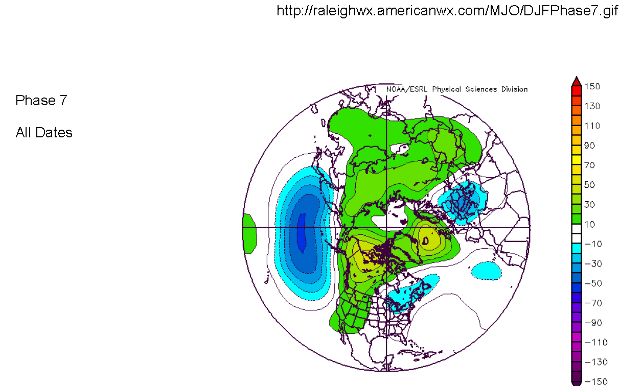
-> er zijn signalen (bij bedoelt in de stratosfeer, later meer daarover!) die wijzen op veranderingen. Interessant is dat de EC MJO verwachting signalen geeft dat deze in fase 7 of 8 terecht komt. Momenteel in een neutrale, weinig betekenisvolle fase. Fase 7 & 8 zijn gunstig voor winterweer, als andere factoren ook mee doen. (Hij bedoelt daarmee dat MJO op zich niet het weer bij ons bepaalt, maar samenstel. fase 7 heb ik hieronder er ook bij gezet. Duidelijk te zien dat er hogedrukimpulsen tussen Ijsland, UK en Noorwegen zijn)
After a diabolical Autumn in terms of warmth and a general lack of interesting week, December has developed into an interesting month and it just goes to show that cold weather IS possible across the UK in some shape or form in a highly +ve NAO pattern with one of the largest and dominant PV anoms you can think of.
-> het huidige weer laat zien dat zelfs bij een zeer positieve NAO met een zeer dominante en krachtige poolwervel er wat licht winters weer mogelijk is
So in summary, I do believe a change will come, just how much of a change is uncertainty. I certainly don't expect a repeat performance of synoptic conditions that were evident during the previous 2 winters for weeks onwards, but I do believe eventually we'll get the opportunity at least to 'open the door' to a more sustained spell of cold weather due to anticyclonic blocking at higher altitudes. As ever in weather, time will well tell!...
-> Samengevat, ik geloof dat verandering er aan komt. De vraag is hoeveel? Hij verwacht zeker niet het winterweer van de afgelopen twee jaar (met daar winterweer dat weken aanhield!). Maar wel dat hogedruk zich zal vormen op noordelijke breedtes.
Zoals altijd in het weer, tijd zal het zeggen.
Mijn eigen bijdrage.
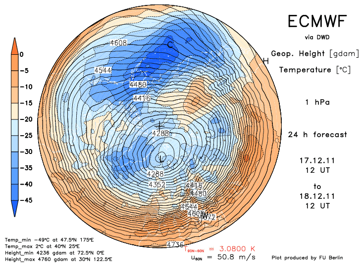
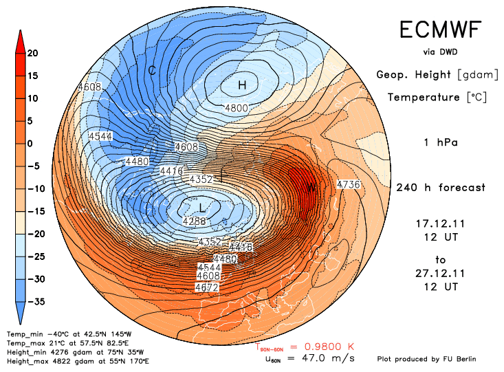
Ondertussen in stratosfeer vindt in de komende 10 dagen vooral op 1hpa en 2hpa behoorlijke opwarming plaats. Het duurt even voordat dit doorsijpelt naar lagere delen. Wat ik begrepen heb vd kenners, is dat het te weinig is voor een SSW, maar wel uiteindelijk de poolwervel minder sterk zal maken (lees langzamerhand meer kansen op blokkades, en of die dan gunstig zijn is natuurlijk de vraag!).
Fase 7 MJO
Just a quick post to highlight my latest thoughts and to reiterate a few others...
From the combination of the avilable information and data that has been discussed here, I certainly believe that we will have to wait until at least the end of the 1st week or into the 2nd week of January before any potential change in pattern develops. The latest EC 32 day from Fri signals little change to the overal picture apart from perhaps high pressure actually building into the UK during early January and bringing a more anticyclonic pattern and allowing the jet stream to pass to the N of the UK. As I highlighted over on TWO, the EC 32 day for a good number of weeks has been excellent in terms of the broader pattern and temperature trends and I have no reason to dismiss its signal now.
-> Uit de beschikbare informatie die nu beschikbaar is, leid ik af dat we zeker tot de eerste week van januari moeten wachten voor verandering. Het EC32 model geeft aan dat er een mogelijkheid is dat in de eerste week van januari hogedruk zich opbouwt boven het Verenigd Koninkrijk. EC32 doet het de laatste tijd erg goed.
What I will place emphasis on once again though, is that despite an unfavourable broader synoptic pattern for sustained cold, December so far hasn't been particularly mild with some very reasonably incursions of cold from NW'lies and some resultant snow for some. Granted primarily away from the south of course, but still, given the +NAO pattern, it's been far from +10C, with heavy rain, drizzle and strong winds for days.
->Hoewel het synoptische patroon slecht is voor langdurige kou, het levert wel de nodige kortdurende koudere onderbrekingen op. Het ontbreekt aan dagenlang 10c plus.
Clearly as Chiono et al have been discussing there are signs evident to point towards potential changes down the line. Interestingly the latest EC MJO forecast is beginning to show signs that within 20 days the MJO may well become a phase 8 or perhaps phase 7 after immerging from a near neutral and highly insignificant phase. Clearly a phase 7 or 8 isn't a bad phase to progress towards, particularly if other factors become involved as well.
-> er zijn signalen (bij bedoelt in de stratosfeer, later meer daarover!) die wijzen op veranderingen. Interessant is dat de EC MJO verwachting signalen geeft dat deze in fase 7 of 8 terecht komt. Momenteel in een neutrale, weinig betekenisvolle fase. Fase 7 & 8 zijn gunstig voor winterweer, als andere factoren ook mee doen. (Hij bedoelt daarmee dat MJO op zich niet het weer bij ons bepaalt, maar samenstel. fase 7 heb ik hieronder er ook bij gezet. Duidelijk te zien dat er hogedrukimpulsen tussen Ijsland, UK en Noorwegen zijn)
After a diabolical Autumn in terms of warmth and a general lack of interesting week, December has developed into an interesting month and it just goes to show that cold weather IS possible across the UK in some shape or form in a highly +ve NAO pattern with one of the largest and dominant PV anoms you can think of.
-> het huidige weer laat zien dat zelfs bij een zeer positieve NAO met een zeer dominante en krachtige poolwervel er wat licht winters weer mogelijk is
So in summary, I do believe a change will come, just how much of a change is uncertainty. I certainly don't expect a repeat performance of synoptic conditions that were evident during the previous 2 winters for weeks onwards, but I do believe eventually we'll get the opportunity at least to 'open the door' to a more sustained spell of cold weather due to anticyclonic blocking at higher altitudes. As ever in weather, time will well tell!...
-> Samengevat, ik geloof dat verandering er aan komt. De vraag is hoeveel? Hij verwacht zeker niet het winterweer van de afgelopen twee jaar (met daar winterweer dat weken aanhield!). Maar wel dat hogedruk zich zal vormen op noordelijke breedtes.
Zoals altijd in het weer, tijd zal het zeggen.
Mijn eigen bijdrage.
Ondertussen in stratosfeer vindt in de komende 10 dagen vooral op 1hpa en 2hpa behoorlijke opwarming plaats. Het duurt even voordat dit doorsijpelt naar lagere delen. Wat ik begrepen heb vd kenners, is dat het te weinig is voor een SSW, maar wel uiteindelijk de poolwervel minder sterk zal maken (lees langzamerhand meer kansen op blokkades, en of die dan gunstig zijn is natuurlijk de vraag!).
Fase 7 MJO
Bericht laatst bijgewerkt: 18-12-2011 10:18
„Et nul ne se connait tant qu'il n'a pas souffert, „C'est une dure loi, mais une loi suprème, „Vieille comme le monde et la fatalité, „Qu'l nous faut du malheur regevoir le baptéme, ~Et qu'a ce triste prix tout doit étre acheté. „Les moissons pour murir out besoin de rosée, „Pour vivre et pour sentir l'homme a besoin de pleura, „La joie a pour symbole une plante brisée, „Humide encore de pluie et couverte de fleurs."