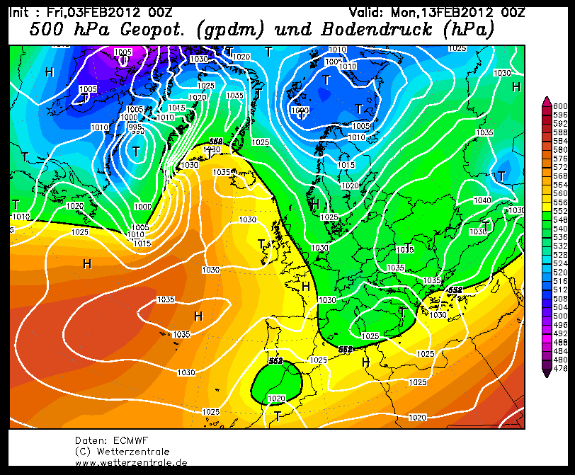
Voorlopig geen zacht weer. Dat bleek al uit de pluim vanmorgen en de diverse opers (UKMO144u matig). Wel zit er volgens NOAA een transitie in. Van hogedruk ten NO van ons, naar meer NW. Zoiets als de EC oper vanmorgen liet zien.
Regarding the upstream pattern, comments from NOAA certainly don't suggest a return to milder conditions.
AT LEAST ON A LARGER SCALE MODELS AGREE THAT A LARGE MID LEVEL HEIGHT ANOMALY WILL BECOME ESTABLISHED OVER THE NORTH CENTRAL ATLANTIC TOWARD THE END OF THE PERIOD...WHICH THEN TELECONNECTS WITH A MEAN TROUGH OVER THE NORTHEAST/NEW ENGLAND AND SMALLER BUT STILL SIGNIFICANT MEAN RIDGE OVER THE NORTH AMERICAN ROCKIES.
That ties in very well with those ECM ensemble spreads I posted earlier, the transition from blocking over Scandi to blocking to the nw is likely to throw the models for a while as they try and plot a course to that.
http://www.hpc.ncep.noaa.gov/preepd/preepd.html
http://forum.netweather.tv/topic/72437-model-discussion-chat-and-commentary-feb-2nd/page__st__240__p__2241907#entry2241907
Regarding the upstream pattern, comments from NOAA certainly don't suggest a return to milder conditions.
AT LEAST ON A LARGER SCALE MODELS AGREE THAT A LARGE MID LEVEL HEIGHT ANOMALY WILL BECOME ESTABLISHED OVER THE NORTH CENTRAL ATLANTIC TOWARD THE END OF THE PERIOD...WHICH THEN TELECONNECTS WITH A MEAN TROUGH OVER THE NORTHEAST/NEW ENGLAND AND SMALLER BUT STILL SIGNIFICANT MEAN RIDGE OVER THE NORTH AMERICAN ROCKIES.
That ties in very well with those ECM ensemble spreads I posted earlier, the transition from blocking over Scandi to blocking to the nw is likely to throw the models for a while as they try and plot a course to that.
http://www.hpc.ncep.noaa.gov/preepd/preepd.html
http://forum.netweather.tv/topic/72437-model-discussion-chat-and-commentary-feb-2nd/page__st__240__p__2241907#entry2241907
Bericht laatst bijgewerkt: 03-02-2012 12:01
„Et nul ne se connait tant qu'il n'a pas souffert, „C'est une dure loi, mais une loi suprème, „Vieille comme le monde et la fatalité, „Qu'l nous faut du malheur regevoir le baptéme, ~Et qu'a ce triste prix tout doit étre acheté. „Les moissons pour murir out besoin de rosée, „Pour vivre et pour sentir l'homme a besoin de pleura, „La joie a pour symbole une plante brisée, „Humide encore de pluie et couverte de fleurs."