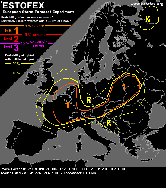
A level 1 was issued for NE France and Benelux mainly for severe wind gusts and an isolated large hail/tornado event.
(..)
SYNOPSIS
A strong upper trough over the Bay of Biscay moves rapidly to the east and affects UK during the night hours. A weak SW-erly flow regime is still present over C-Europe. Embedded small-scale waves will be the foci for enhanced thunderstorm development. Hot and dry conditions exist atop the Mediterranean area.
DISCUSSION
... France, Benelux, W-Germany and parts of UK ...
Apparently, the intense and progressive vorticity lobe and attendant synoptic boundaries dictate convective initiation (CI). The mid/upper streamline pattern becomes supportive for prolonged/deep lift over NE France/Benelux, with diffluent pattern just ahead of the main trough axis. In fact, unusually strong diffluence is expected over Benelux during the evening hours in response to a negative tilted trough evolution over UK.
A step down to the surface shows an eastward moving occlusion, coupled to the sharp mid-level trough axis, which also increases lift for DMC. Timing of the trough axis/occlusion will be 15Z over C-France, approaching Benelux from the SW at 18Z onwards. Despite overall favorable forcing, we keep an eye on the unusual trough axis configuration (E-W alignement during the evening hours) over UK, which may place NE France/Benelux beneath intense subsidence during the time frame with peak DMC activity.
Modified forecast soundings show somewhat indifferent profiles. Adequate BL moisture is present with surface dewpoints in the mid tens with similar values in the 950 hPa layer. Lapse rates reveal near neutral values but steepen somewhat in the course of the day as somewhat cooler mid-level temperatures overspread the moist BL, so 500-1000 J/kg MLCAPE are expected. A concentrated tongue of higher BL moisture along the confluence zone/occlusion may assist in even higher values, so adequate CAPE for DMC is forecast.
Kinematics not as straightforward as CAPE forecast. Prefrontal diffluent streamline pattern offers 10-15 m/s DLS (E-France/Benelux) with 20 m/s DLS just along the occlusion/trough axis and 20-30 m/s DLS over the E-English Channel/W-Belgium and Netherlands, as an intense 35 m/s 500 hPa streak approaches from the SW. Hence, probabilities for organized DMC increase from SW-Germany/E-France to Belgium/Netherlands.
Early and scattered to widespread CI is expected over most parts of C-France. Diffluent flow regime and messy surface wind field assists in random development with slow and erratic storm motions. During the more discrete initiation stage, large hail and strong wind gusts will be the main hazard. Locally heavy rain accompanies that activity. At 15Z onwards however, incoming forcing and sharpening occlusion start to be the foci for widespread line-up of storms and an extensive eastward moving MCS is forecast to cross E-France at around 18Z and entering SW/W-Germany thereafter. However current thinking is that this MCS remains quite disorganized with only small line segments showing some better organization (embedded multicells/isolated supercells). The main risk will be isolated large hail and strong to isolated severe wind gusts. However a narrow swath or two of severe wind gust reports over E-France can't be ruled out. The MCS weakens, while entering W/SW Germany and becomes sub-severe thereafter.
Further north, strength of forcing and incoming intense mid-level jet may assist in a well organized MCS event, which consolidates over NE France with rapid movement towards Benelux (18Z onwards). A few concerns exist:
a) Potential scattered CI in the prefrontal air mass over Benelux during the afternoon hours (beneath diffluence) may spark a cluster of storms ahead of the incoming MCS, which may assist in more stable inflow air parcels for the approaching MCS
b) CAPE plume also fans out ahead of the MCS
c) strong subsidence overspreading the area of interest
However most models show a potential strong MCS event and given strength of forcing, we agree that this solution seems to be plausible. Hence, a swath of concentrated strong to severe wind gusts may evolve over Belgium, the Netherland and NW Germany after 18Z. An isolated tornado event can't be ruled out with increase of LL shear and lowering LCLs. Heavy rainfall may occur but progressive nature of storms probably precludes excessive rainfall events.
For now, we do not want to include a level 2 over Benelux with ongoing uncertainties. The level 1 risk becomes more conditional over E-/C-France.
Scattered storms are also forecast over SE-UK, placed beneath the left exit region of the mid/upper jet. Strength of diffluence and connection to the moisture plume over NE-France may result in scattered thunderstorm development and rapid clustering. Heavy rainfall will be the main hazard with isolated marginal hail and strong wind gusts in stronger/more discrete storms. Drier air mixes in from the SW after 21Z and brings thunderstorm chances to an end. Wrap-around moisture may also result in heavy rainfall over parts of UK/Scotland during the night.