Al zal het gisteren voor velen veel spectaculairder zijn geweest.. 
http://estofex.org/
... Benelux and far NW-Germany ...
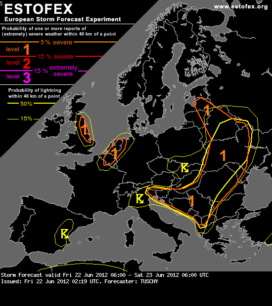
Very mixed signals are present for today's forecast. Any forcing remains weak/diffuse, but favorable mid-level jet configuration may temporarily assist in better lift during the afternoon hours (with strongest subsidence just to the east). Another limiting point will be quite thick cloud cover within the moist postfrontal air mass. However, a few high resolution models indicate some breaks in the cloud fields, so at least low-end diabatic heating is possible (and proably already enough for initiation). Right now, we expect showers and isolated thunderstorms during the afternoon and evening hours, affecting Benelux and far NW Germany. Main concern right now will be a few shallow supercells with warm EL temperatures forecast. Enhanced LL CAPE and 15 m/s LL shear (200 m^2/s^2 SRH-1) will overlap and hence any stronger updraft may be able to rotate with an isolated tornado risk. We issued a level 1/15-% lightning probability overlap for this event. Convection rapidly vanishes after sunset.
http://estofex.org/
... Benelux and far NW-Germany ...
Very mixed signals are present for today's forecast. Any forcing remains weak/diffuse, but favorable mid-level jet configuration may temporarily assist in better lift during the afternoon hours (with strongest subsidence just to the east). Another limiting point will be quite thick cloud cover within the moist postfrontal air mass. However, a few high resolution models indicate some breaks in the cloud fields, so at least low-end diabatic heating is possible (and proably already enough for initiation). Right now, we expect showers and isolated thunderstorms during the afternoon and evening hours, affecting Benelux and far NW Germany. Main concern right now will be a few shallow supercells with warm EL temperatures forecast. Enhanced LL CAPE and 15 m/s LL shear (200 m^2/s^2 SRH-1) will overlap and hence any stronger updraft may be able to rotate with an isolated tornado risk. We issued a level 1/15-% lightning probability overlap for this event. Convection rapidly vanishes after sunset.
Buien Blijven Boeien