Storm Forecast
Valid: Sun 24 Jun 2012 06:00 to Mon 25 Jun 2012 06:00 UTC
Issued: Sat 23 Jun 2012 21:39
Forecaster: PISTOTNIK
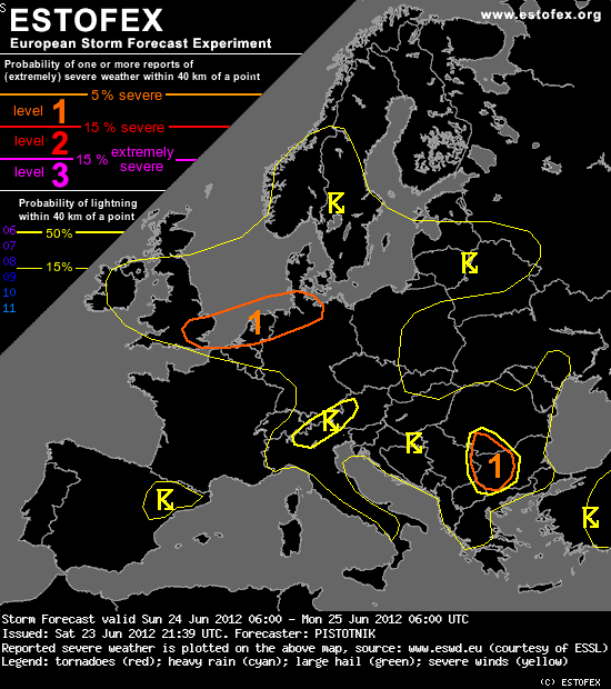
A level 1 was issued for SE-ern England, the Netherlands and N-ern Germany for severe wind gusts and to a lesser extent for tornadoes.
A level 1 was issued for far S-Romania and parts of Bulgaria mainly for heavy rainfall and isolated large hail.
SYNOPSIS
Large-scale weather pattern over Europe is characterized by an unseasonably strong zonal flow at the Southern flank of an extensive low-pressure system centered over the North Sea. Its cold front enters North-Central Europe and moves southeastward during the forecast period. Chances for deep convection along and ahead of this cold front seem to be limited (and are only reflected by a 15% thunder line) due to its ana-front structure, due to limited boundary-layer moisture and rather poor mid-level lapse rates. However, a pronounced upper-level trough in its wake may set the stage for a round of postfrontal convection in an impressive kinematic setup.
Meanwhile, summerly calm conditions prevail over the Mediterranean region.
DISCUSSION
... E-ern England, the Netherlands, N-ern Germany ...
A pronounced short-wave trough at upper levels will move into the region from the west. Latest WV satellite imagery (Sat 18 UTC) raises the confidence that also an accompanying dry intrusion will overspread the humid lower levels. Consequently, strong synoptic- and mesoscale lift and the build-up and release of potential instability will soon establish neutral or marginally unstable profiles in the wake of the cold front. Vertical wind shear is impressive beneath the jet streak, with 0-6 km shear up to 40 m/s, 0-1 km shear up to 15 m/s and a good chance for a temporary backing of the low-level wind field ahead of the trough. Showers and low-topped, weakly electrified thunderstorms are expected which will have a chance to produce severe wind gusts.
The positive tilt of the trough axis and its accordingly acute angle to the upper-level flow direction seem to be unfavourable for the concentration of convective activity into a larger comma-like feature. Instead, several strongly forced multicells are a more likely scenario, which may be able to develop short bowing segments. Those convective cells which manage to sustain a more isolated character have also an enhanced chance to produce rotating updrafts and even one or two tornadoes, considering the strong LLS and favourably veering wind profiles (SRH around 200 m^2/s^2).
Activity will weaken around sunset while moving into Eastern Germany and Poland due to boundary layer cooling and a gradual slackening of the short-wave trough. It is also noteworthy that today's model runs rather delayed the arrival of this trough, therefore rather decreasing the threat due to a less favourable diurnal timing.
Valid: Sun 24 Jun 2012 06:00 to Mon 25 Jun 2012 06:00 UTC
Issued: Sat 23 Jun 2012 21:39
Forecaster: PISTOTNIK
A level 1 was issued for SE-ern England, the Netherlands and N-ern Germany for severe wind gusts and to a lesser extent for tornadoes.
A level 1 was issued for far S-Romania and parts of Bulgaria mainly for heavy rainfall and isolated large hail.
SYNOPSIS
Large-scale weather pattern over Europe is characterized by an unseasonably strong zonal flow at the Southern flank of an extensive low-pressure system centered over the North Sea. Its cold front enters North-Central Europe and moves southeastward during the forecast period. Chances for deep convection along and ahead of this cold front seem to be limited (and are only reflected by a 15% thunder line) due to its ana-front structure, due to limited boundary-layer moisture and rather poor mid-level lapse rates. However, a pronounced upper-level trough in its wake may set the stage for a round of postfrontal convection in an impressive kinematic setup.
Meanwhile, summerly calm conditions prevail over the Mediterranean region.
DISCUSSION
... E-ern England, the Netherlands, N-ern Germany ...
A pronounced short-wave trough at upper levels will move into the region from the west. Latest WV satellite imagery (Sat 18 UTC) raises the confidence that also an accompanying dry intrusion will overspread the humid lower levels. Consequently, strong synoptic- and mesoscale lift and the build-up and release of potential instability will soon establish neutral or marginally unstable profiles in the wake of the cold front. Vertical wind shear is impressive beneath the jet streak, with 0-6 km shear up to 40 m/s, 0-1 km shear up to 15 m/s and a good chance for a temporary backing of the low-level wind field ahead of the trough. Showers and low-topped, weakly electrified thunderstorms are expected which will have a chance to produce severe wind gusts.
The positive tilt of the trough axis and its accordingly acute angle to the upper-level flow direction seem to be unfavourable for the concentration of convective activity into a larger comma-like feature. Instead, several strongly forced multicells are a more likely scenario, which may be able to develop short bowing segments. Those convective cells which manage to sustain a more isolated character have also an enhanced chance to produce rotating updrafts and even one or two tornadoes, considering the strong LLS and favourably veering wind profiles (SRH around 200 m^2/s^2).
Activity will weaken around sunset while moving into Eastern Germany and Poland due to boundary layer cooling and a gradual slackening of the short-wave trough. It is also noteworthy that today's model runs rather delayed the arrival of this trough, therefore rather decreasing the threat due to a less favourable diurnal timing.