Ik vind deze de laatste tijd dichter bij de waarheid zitten, geen idee wie het zijn overigens...
(Schaal loopt tot 12)
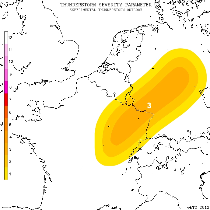
A level 3 was issued for NE France, SW Germany and C Germany mainly for large hail and strong wind gusts.
A level 2 to level 1 surrounds the MTL mainly for marginal hail and strong wind gusts.
DISCUSSION
Within the transition zone between warm air under the ridge and cooler air over the Atlantic, substantial low level moisture should be present, with 18-20 C dew point expected. Lapse rates are expected to be less steep than on Monday. There should also be less convective inhibition. This suggests that CAPE will be less. It appears likely that scattered storms will develop during the day, and some may already be ongoing early in the day. Wind shear will increase as the aforementioned jets overspreads this air-mass, which should yield a large area with an overlap of 1000-1500 J/kg and 20-25 m/s DLS. Storms developing here will include supercells and bowing segments capable of producing large hail and severe wind gusts. Quote selectie
(Schaal loopt tot 12)
A level 3 was issued for NE France, SW Germany and C Germany mainly for large hail and strong wind gusts.
A level 2 to level 1 surrounds the MTL mainly for marginal hail and strong wind gusts.
DISCUSSION
Within the transition zone between warm air under the ridge and cooler air over the Atlantic, substantial low level moisture should be present, with 18-20 C dew point expected. Lapse rates are expected to be less steep than on Monday. There should also be less convective inhibition. This suggests that CAPE will be less. It appears likely that scattered storms will develop during the day, and some may already be ongoing early in the day. Wind shear will increase as the aforementioned jets overspreads this air-mass, which should yield a large area with an overlap of 1000-1500 J/kg and 20-25 m/s DLS. Storms developing here will include supercells and bowing segments capable of producing large hail and severe wind gusts. Quote selectie
V?n?, v?d?, v?c?

 . Ik hoop toch op een verfrissende
