Stewart (stelt op NetWeather de Lange Termijn op) twijfelt of El Nino er wel komt. Dit door de blijkbaar stevige invloed van de negatieve PDO. Verder wijst hij op de QBO, volgens hem wijst een momenteel dat op een zwakkere poolwervel dan anders. Tenslotte is hij benieuwd naar de sneeuwbedekking in oktober (toevoeging, waarschijnlijk denkt hij hierbij aan het onderzoek van Cohen)
I wouldn't be banking on this winter being an El Nino one. The -PDO is agressively strong and has full atmospheric coupling. We can see this in the strong residual SST warm anomalies in the Sea of Japan and in the NW Atlantic off Newfoundland. These anomalies are strong and +ve zonal wind anomalies across the tropics extremely weak. That has severely dented the probability of a warm ENSO phase this winter, indeed the prospects of us going back into Nina phase in the spring have increased over the last week or so.
Initial analysis of the QBO suggests a weaker than normal polar vortex this winter, with an interesting focus on increased probability of a disruption of the vortex late November or early December and again around New Year. The profile of hemispheric SSTAs is also pointing to a -ve height anomaly across Europe. All eyes on October NH snowcover. Should come in above average if we are on course for a cold winter.
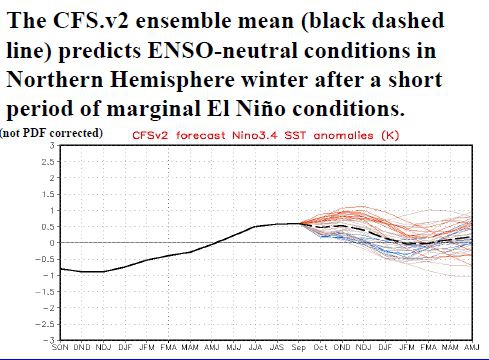
Plaatje ENSO verwachting, door CFS2, link naar PDO waarden waar Stewart naar verwijst http://jisao.washington.edu/pdo/PDO.latest & sneeuwbedekking is hier te vinden http://climate.rutgers.edu/snowcover/chart_daily.php?ui_year=2012&ui_day=268&ui_set=2
I wouldn't be banking on this winter being an El Nino one. The -PDO is agressively strong and has full atmospheric coupling. We can see this in the strong residual SST warm anomalies in the Sea of Japan and in the NW Atlantic off Newfoundland. These anomalies are strong and +ve zonal wind anomalies across the tropics extremely weak. That has severely dented the probability of a warm ENSO phase this winter, indeed the prospects of us going back into Nina phase in the spring have increased over the last week or so.
Initial analysis of the QBO suggests a weaker than normal polar vortex this winter, with an interesting focus on increased probability of a disruption of the vortex late November or early December and again around New Year. The profile of hemispheric SSTAs is also pointing to a -ve height anomaly across Europe. All eyes on October NH snowcover. Should come in above average if we are on course for a cold winter.
Plaatje ENSO verwachting, door CFS2, link naar PDO waarden waar Stewart naar verwijst http://jisao.washington.edu/pdo/PDO.latest & sneeuwbedekking is hier te vinden http://climate.rutgers.edu/snowcover/chart_daily.php?ui_year=2012&ui_day=268&ui_set=2
Bericht laatst bijgewerkt: 25-09-2012 15:37
„Et nul ne se connait tant qu'il n'a pas souffert, „C'est une dure loi, mais une loi suprème, „Vieille comme le monde et la fatalité, „Qu'l nous faut du malheur regevoir le baptéme, ~Et qu'a ce triste prix tout doit étre acheté. „Les moissons pour murir out besoin de rosée, „Pour vivre et pour sentir l'homme a besoin de pleura, „La joie a pour symbole une plante brisée, „Humide encore de pluie et couverte de fleurs."