Zou wel eens leuk kunnen worden morgen 
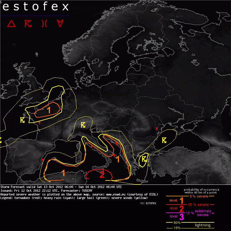
A level 1 was issued for parts of N-France mainly for marginal to isolated large hail and strong wind gusts.
... The English Channel, N-France and parts of Benelux ...
A marginal level 1highlights a strong impulse, which enters the W-English Channel during the start of the forecast with a constant shift towards the east. Attendant strong convergence zone/occlusion affects N-France during the daytime hours and reveals a fast motion to the east due to the strong impulse atop. With a slow down of that impulse over the S-North Sea during the evening hours onwards, a decoupling of strongest forcing, the occlusion and BL moisture/instability fields occurs, which should lower the thunderstorm and severe risk after sunset.
Current thoughts are that cold mid-levels atop onshore flowing maritime BL air mass create 500-800 J/kg SBCAPE, supportive of scattered thunderstorms over N-France and offshore areas. Isolated large hail and strong wind gusts accompany that activity. Betimes, thunderstorm activity also increases somewhat over NE France, Belgium and W-Germany with the eastward moving occlusion. A broken line of showers and isolated thunderstorms will pose a risk of strong to isolated severe wind gusts and marginal hail with a decrease in severe probabilities after sunset. Due to the occlusion, the low probability lightning area was expanded far to the E/SE.
Another strong impulse affects the Bay of Biscay during the overnight hours, which also increases the lightning probabilities over that area. Strong wind gusts and isolated marginal hail are forecast. Storms might also move ashore over W-France. With impressive upper divergence after 03Z, a cluster of storms may impact the W-coast of France with heavy rain although models diverge with that solution.
A level 1 was issued for parts of N-France mainly for marginal to isolated large hail and strong wind gusts.
... The English Channel, N-France and parts of Benelux ...
A marginal level 1highlights a strong impulse, which enters the W-English Channel during the start of the forecast with a constant shift towards the east. Attendant strong convergence zone/occlusion affects N-France during the daytime hours and reveals a fast motion to the east due to the strong impulse atop. With a slow down of that impulse over the S-North Sea during the evening hours onwards, a decoupling of strongest forcing, the occlusion and BL moisture/instability fields occurs, which should lower the thunderstorm and severe risk after sunset.
Current thoughts are that cold mid-levels atop onshore flowing maritime BL air mass create 500-800 J/kg SBCAPE, supportive of scattered thunderstorms over N-France and offshore areas. Isolated large hail and strong wind gusts accompany that activity. Betimes, thunderstorm activity also increases somewhat over NE France, Belgium and W-Germany with the eastward moving occlusion. A broken line of showers and isolated thunderstorms will pose a risk of strong to isolated severe wind gusts and marginal hail with a decrease in severe probabilities after sunset. Due to the occlusion, the low probability lightning area was expanded far to the E/SE.
Another strong impulse affects the Bay of Biscay during the overnight hours, which also increases the lightning probabilities over that area. Strong wind gusts and isolated marginal hail are forecast. Storms might also move ashore over W-France. With impressive upper divergence after 03Z, a cluster of storms may impact the W-coast of France with heavy rain although models diverge with that solution.