So what does a solid longwave pattern centred around Kamchatkan ridge / North Atlantic ridge and NW European trough mean going forward ?
The GEFS mean height anomalt days 11-15 depicts this type of pattern.
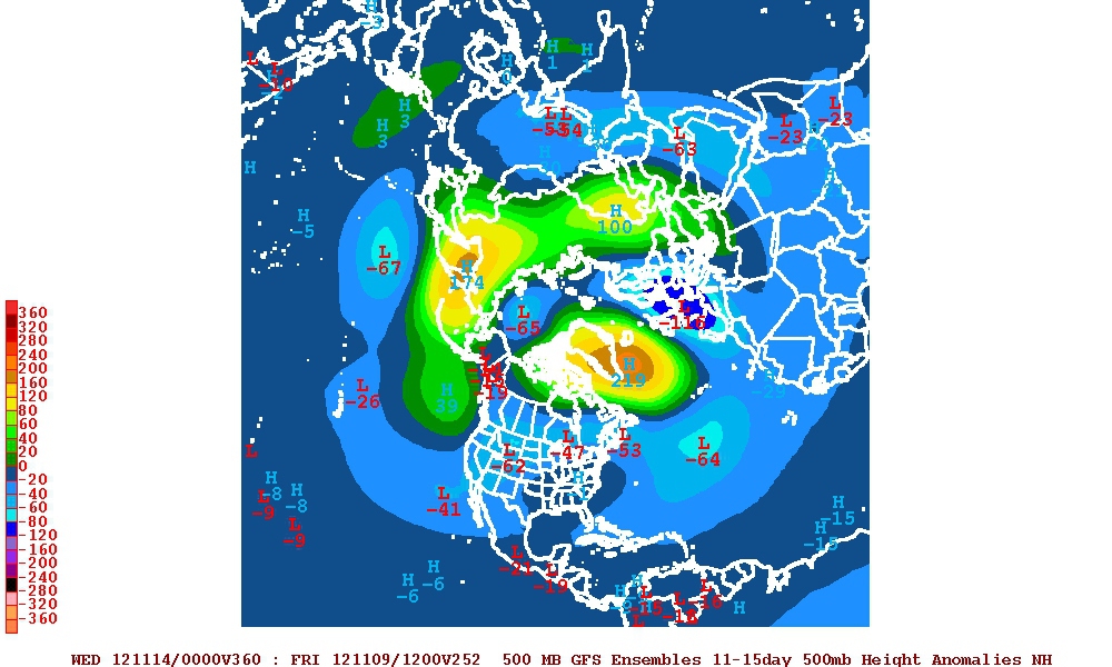
If we assume this to be setting the ground for what the H5 anomaly for November will eventually be, then we can look at historical precedent given that patterns at this time of year begin to lock down for the winter.
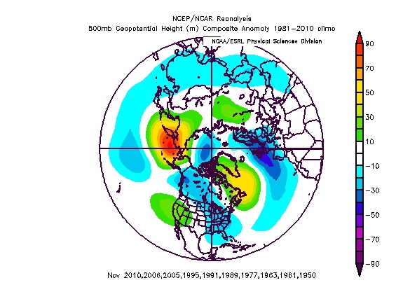
Our analogues, which are an excellent representation of the three major hemispheric anomalous ridges:
Rolled forward into December:
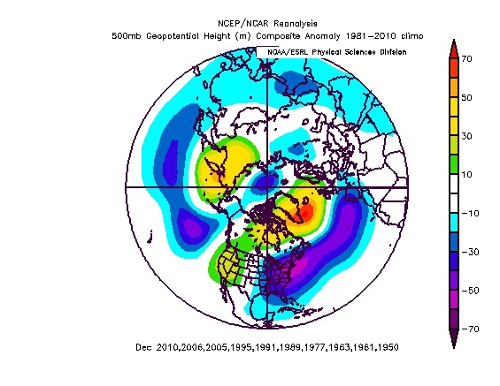
This idea of a negative (potentially deeply negative) NAO during December has a lot of credence when you consider the range of teleconnective signals, and now seemingly ECM long range modelling.
Er werd nog een vraag gesteld
Interesting GP however I don't remember apart from 2010, that many of the more recent analogues ie 2005/2006 winters produced much in the way of cold/snow - Dec 06 was rather like 2011 if I recall it right. 2005 I think cold lovers had to wait until the deep realms of Feb for any decent snow and even then it was questionable compared to some recent years. My question is what was different about them years as it looks like northern blocking was prevelent.
Stewarts antwoord
I think the interpretation of what these analogues might mean in terms of temperature and ppn should be seen in the context of the shift in the PDO from 2007.
The principal reason I think for the anomalous ridges is the disconnect that we are seeing between angular momentum and current ENSO signal, which effectively is reinforcing this idea of an El Nino within a cold PDO type scenario. The pattern is effectively a hybrid, which is enhancing the net impacts of low Arctic sea ice and SSTA in the North Atlantic.
The GEFS mean height anomalt days 11-15 depicts this type of pattern.
If we assume this to be setting the ground for what the H5 anomaly for November will eventually be, then we can look at historical precedent given that patterns at this time of year begin to lock down for the winter.
Our analogues, which are an excellent representation of the three major hemispheric anomalous ridges:
Rolled forward into December:
This idea of a negative (potentially deeply negative) NAO during December has a lot of credence when you consider the range of teleconnective signals, and now seemingly ECM long range modelling.
Er werd nog een vraag gesteld
Interesting GP however I don't remember apart from 2010, that many of the more recent analogues ie 2005/2006 winters produced much in the way of cold/snow - Dec 06 was rather like 2011 if I recall it right. 2005 I think cold lovers had to wait until the deep realms of Feb for any decent snow and even then it was questionable compared to some recent years. My question is what was different about them years as it looks like northern blocking was prevelent.
Stewarts antwoord
I think the interpretation of what these analogues might mean in terms of temperature and ppn should be seen in the context of the shift in the PDO from 2007.
The principal reason I think for the anomalous ridges is the disconnect that we are seeing between angular momentum and current ENSO signal, which effectively is reinforcing this idea of an El Nino within a cold PDO type scenario. The pattern is effectively a hybrid, which is enhancing the net impacts of low Arctic sea ice and SSTA in the North Atlantic.
„Et nul ne se connait tant qu'il n'a pas souffert, „C'est une dure loi, mais une loi suprème, „Vieille comme le monde et la fatalité, „Qu'l nous faut du malheur regevoir le baptéme, ~Et qu'a ce triste prix tout doit étre acheté. „Les moissons pour murir out besoin de rosée, „Pour vivre et pour sentir l'homme a besoin de pleura, „La joie a pour symbole une plante brisée, „Humide encore de pluie et couverte de fleurs."