http://forum.netweather.tv/topic/58354-technical-model-discussion/page__st__1600#entry2401892
Plaatjes in bovenstaande bericht te vinden!
A couple of considerations to put along current modelling.
The last 30 days NH circulation shows a particular +ve height anomaly across the Northern Pacific extending from the Aleutians to Kamchatka.
In part, the near record advance in Eurasian snowcover can be seen to be influencing this. 250hPa winds over eastern Asia are displaced southward as the cold block is encountered (this is well documented by Cohen). The Asian jet is strengthened and associated with an upper low as the troughing on the poleward side of the jet extends well into the middle latitudes of the Pacific.
This leaves a relatively strong eddy to develop in the higher latitudes which is our North Pacific ridge. Even with a +AO phase, this is adopting a high latitude for this feature (one of the key reasons why the stratospheric lead is not enganging with the troposphere).
The presence of a strong +ve height anomaly teleconnects to a trough off the eastern US and consequent ridge in the North Atlantic.
With no prospect of a reversal in the upstream pattern over Asia, this looks a rock solid modelling feature, set to dominate the NH circulation. The GEFS 12z run tonight has this throughout the run.
GEFS for final weak of November has the Aleutian ridge as an extremely strong and poleward displaced. The downstream teleconnector over the North Atlantic is well modelled, and actually gains intensity in the final stages of the output. The SSTA both in the North Atlantic will reinforce this pattern.
The key question is therefore the mean state of the AO / NAO which will influence the northern extent of this very blocked pattern.
I suggest that with a strong collaboration of MJO wave, poleward +AAMr signal and succession of Wave 2 activity in the next 2 weeks, the stratospheric vortex may be on the bring of collapse 1st week December and ripe for a higher latitide block to take root in December. Whilst not totally against any Scandinavian ridge, I think the wavelengths here more favor a ridge to our W / NW.
edit
GEFS and ECM mean height anomalies at day 10 are in very good agreement w/r/t the longwave pattern across the NH, depicting three anomalous ridges extending into the Arctic.
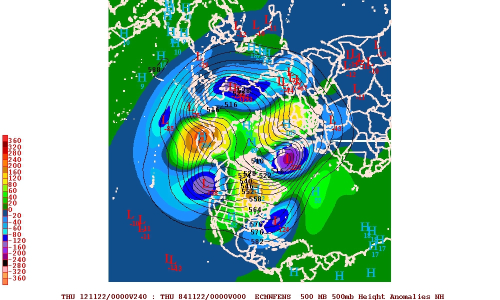
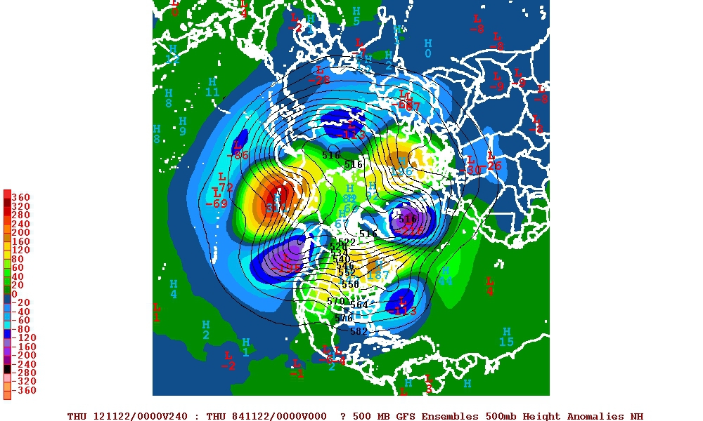
The key message is that the AO is trending negative as we head into the final week of the month. It's a bit of a race at the moment to see whether the ridge to our NE extends over the top or the ridge over Canada migrates eastwards, but the final evolution here looks to be southern Greenland and Iceland area for the block to lock (in line with upstream ridge placement).
Plaatjes in bovenstaande bericht te vinden!
A couple of considerations to put along current modelling.
The last 30 days NH circulation shows a particular +ve height anomaly across the Northern Pacific extending from the Aleutians to Kamchatka.
In part, the near record advance in Eurasian snowcover can be seen to be influencing this. 250hPa winds over eastern Asia are displaced southward as the cold block is encountered (this is well documented by Cohen). The Asian jet is strengthened and associated with an upper low as the troughing on the poleward side of the jet extends well into the middle latitudes of the Pacific.
This leaves a relatively strong eddy to develop in the higher latitudes which is our North Pacific ridge. Even with a +AO phase, this is adopting a high latitude for this feature (one of the key reasons why the stratospheric lead is not enganging with the troposphere).
The presence of a strong +ve height anomaly teleconnects to a trough off the eastern US and consequent ridge in the North Atlantic.
With no prospect of a reversal in the upstream pattern over Asia, this looks a rock solid modelling feature, set to dominate the NH circulation. The GEFS 12z run tonight has this throughout the run.
GEFS for final weak of November has the Aleutian ridge as an extremely strong and poleward displaced. The downstream teleconnector over the North Atlantic is well modelled, and actually gains intensity in the final stages of the output. The SSTA both in the North Atlantic will reinforce this pattern.
The key question is therefore the mean state of the AO / NAO which will influence the northern extent of this very blocked pattern.
I suggest that with a strong collaboration of MJO wave, poleward +AAMr signal and succession of Wave 2 activity in the next 2 weeks, the stratospheric vortex may be on the bring of collapse 1st week December and ripe for a higher latitide block to take root in December. Whilst not totally against any Scandinavian ridge, I think the wavelengths here more favor a ridge to our W / NW.
edit
GEFS and ECM mean height anomalies at day 10 are in very good agreement w/r/t the longwave pattern across the NH, depicting three anomalous ridges extending into the Arctic.
The key message is that the AO is trending negative as we head into the final week of the month. It's a bit of a race at the moment to see whether the ridge to our NE extends over the top or the ridge over Canada migrates eastwards, but the final evolution here looks to be southern Greenland and Iceland area for the block to lock (in line with upstream ridge placement).
Bericht laatst bijgewerkt: 12-11-2012 12:12
„Et nul ne se connait tant qu'il n'a pas souffert, „C'est une dure loi, mais une loi suprème, „Vieille comme le monde et la fatalité, „Qu'l nous faut du malheur regevoir le baptéme, ~Et qu'a ce triste prix tout doit étre acheté. „Les moissons pour murir out besoin de rosée, „Pour vivre et pour sentir l'homme a besoin de pleura, „La joie a pour symbole une plante brisée, „Humide encore de pluie et couverte de fleurs."