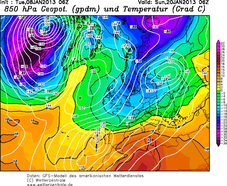
GFS06Z UGKB petje af. +SSW update.
Bericht van: Ruben (Ås, nabij Oslo, Noorwegen) , 08-01-2013 11:44
Hij is weer fijn.
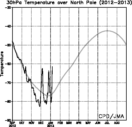
En nog een kort updatetje over de SSW. 30 hPa temperaturen boven de pool zijn nu ook duidelijk aan het stijgen.
Onzekerheid de komende tijd in de modellen (voor wat stratosfeer betreft) is vrij groot. Gaat de polar vortex zich hergroeperen, of blijft zij gespleten?
Een bemoedigende update op het netweatherforum vanochtend (de bron van dit bericht ken ik niet, het is een gebruiker die weinig post):
I'm sure you'll be pleased to hear: the ECM Ens 240-360h is not as bullish as the weekend models, which were returning a re-intensifying PV polewards. The latest run has back-tracked to a large extent, and now maintains a split vortex (in the mid-upper strat) with centres of action in the vicinity of Canada, as well as close to Siberia, and polar ridging from both the Pacific and Atlantic sides, albeit weaker than currently. There also appears to be further warming from the Canadian sector into the polar region, totally oposite to previous. The GFS Ens output at this timescale does something very similar, with both vortex centres in a similar position and also in a very weakened state.
This adds weight to the expectation of no rapid return to 'normality' in the near future, and as picked up by last nights ECM 32dayer, which maintains the negative pattern and Greenland blocking through to first week of Feb, and relative cold/spells of snow for UK and much of central/northern Europe throughout. Quote selectie
En nog een kort updatetje over de SSW. 30 hPa temperaturen boven de pool zijn nu ook duidelijk aan het stijgen.
Onzekerheid de komende tijd in de modellen (voor wat stratosfeer betreft) is vrij groot. Gaat de polar vortex zich hergroeperen, of blijft zij gespleten?
Een bemoedigende update op het netweatherforum vanochtend (de bron van dit bericht ken ik niet, het is een gebruiker die weinig post):
I'm sure you'll be pleased to hear: the ECM Ens 240-360h is not as bullish as the weekend models, which were returning a re-intensifying PV polewards. The latest run has back-tracked to a large extent, and now maintains a split vortex (in the mid-upper strat) with centres of action in the vicinity of Canada, as well as close to Siberia, and polar ridging from both the Pacific and Atlantic sides, albeit weaker than currently. There also appears to be further warming from the Canadian sector into the polar region, totally oposite to previous. The GFS Ens output at this timescale does something very similar, with both vortex centres in a similar position and also in a very weakened state.
This adds weight to the expectation of no rapid return to 'normality' in the near future, and as picked up by last nights ECM 32dayer, which maintains the negative pattern and Greenland blocking through to first week of Feb, and relative cold/spells of snow for UK and much of central/northern Europe throughout. Quote selectie
 (oeps)

