torm Forecast
Valid: Fri 12 Apr 2013 06:00 to Sat 13 Apr 2013 06:00 UTC
Issued: Thu 11 Apr 2013 22:03
Forecaster: TUSCHY
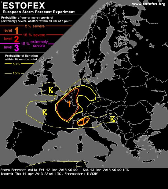
A level 1 was issued for NE France, Benelux and far W-Germany mainly for an isolated large hail and a funnel/tornado event.
... France, Benelux and parts of Germany ...
A weak mid-level vorticity lobe traverses the highlighted area from W to E during the forecast period, inducing some lift next to the cyclonically curved mid-level streak, which places most of the area beneath the favorable left exit region. Also, numerous weaker pieces from this jet loosen and result in areas with regionally enhanced lift. Aforementioned mesoscale convergence zones but also the orography itself result in regionally enhanced thunderstorm activity. This messy picture makes it hard to highlight the hot spots for lightning activity and therefore a coarse lightning area was added.
A combination of mid-level polar air atop well mixed maritime Atlantic air results in modest MLCAPE build-up on the order of 300 - 600 J/kg with EZ being once again on the lower-end side. The air mass will be weakly capped and therfore prone to early initiation.
DLS remains weak during the forecast, although latest model outputs increased the 6 km bulk shear to 15 m/s, which would be enough for a few better organized thunderstorms. Placed in the SE-quadrant of the UK low, a broad area with deeply veered flow is expected, nicely reflected in SRH fields, which yield values of 100-150 m^2/s^2 around noon, increasing to 200 m^2/s^2 during the evening hours. Given complex surface boundary pattern, we would not be surprised to see a few storms with a more pronounced deviant storm motion, which would locally augment helicity values significantly.
Expect scattered to widespread storms to evolve over France until noon from W to E with increasing activity trends thereafter over Benelux and Germany. Given broadening CAPE profiles within the hail growth zone and 15 m/s DLS, marginal hail is likely and an isolated large hail event (1.5 to 2 cm) can't be ruled out. Gusty winds also accompany strongest storms. The highest probabilities for an isolated tornado event arise from C France to Benelux and probably into W-Germany, especially during the late afternoon hours, when still available and nearly uncapped SBCAPE and increasing LL directional shear overlap. A level 1 was issued mainly for those areas, where most of the aforementioned parameters overlap.
After sunset, rapid BL cooling should bring CAPE values down and also the thunderstorm activity. However, stronger forcing and a lingering MUCAPE plume may support isolated and short-lived thunderstorms over Benelux and NW/N-Germany until midnight. This activity will be sub-severe.
Kampioen roltrapzingen https://instagram.com/rick_bekker?igshid=NGExMmI2YTkyZg==