Uitleg die ik vond via de site van NOAA
A multiple ingredient, composite index that includes 0-6 km bulk wind difference (6BWD), 0-1 km storm-relative helicity (SRH1), surface parcel CAPE (sbCAPE), and surface parcel LCL height (sbLCL). This version of STP mimics the original formulation presented by Thompson et al. (2003) by using fixed-layer calculations of vertical shear, and substitutes the surface lifted parcels as an alternative to the ML parcels in the "effective layer" version of STP.
The index is formulated as follows:
STP = (sbCAPE/1500 J kg-1) * ((2000-sbLCL)/1000 m) * (SRH1/150 m2 s-2) * (6BWD/20 m s-1)
The sbLCL term is set to 1.0 when sbLCL < 1000 m, and set to 0.0 when sbLCL > 2000 m; the 6BWD term is capped at a value of 1.5 for 6BWD > 30 m s-1, and set to 0.0 when 6BWD < 12.5 m s-1.
A majority of significant tornadoes (F2 or greater damage) have been associated with STP values greater than 1, while most non-tornadic supercells have been associated with values less than 1 in a large sample of RAP analysis proximity soundings.
Additional information can be found here and (Please open this link in another browser window.)
Het komt er eigenlijk op neer, als de significant tornado parameter dus hoger en hoger wordt, hoe groter de kans op een tornado .
.
Volgens NOAA zijn de meeste tornados in de VS (bij F2 of groter) geassocieerd met een STP waarden meer dan 1, terwijl de meeste non-tornadic supercells zijn geassocieerd met een STP lager dan 1.
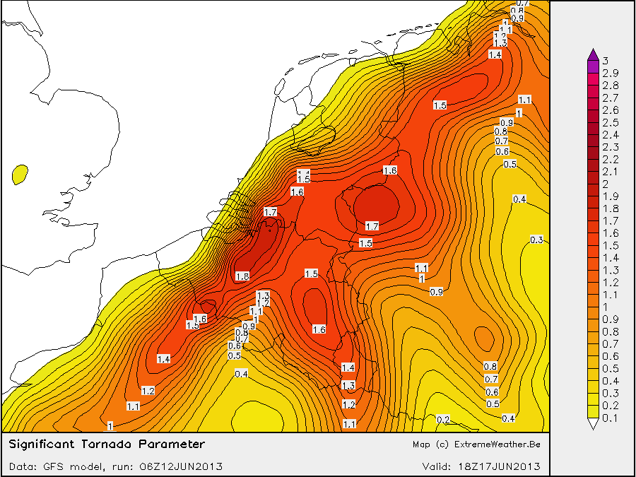
Ik weet niet welke formule het kaartje van Pascal weergeeft maar volgens de formule die hierboven is gegeven (en ik gebruik voor plotten van mijn stp kaartjes) kom ik met een STP van max 1.8 voor het zelfde tijdstip.
A multiple ingredient, composite index that includes 0-6 km bulk wind difference (6BWD), 0-1 km storm-relative helicity (SRH1), surface parcel CAPE (sbCAPE), and surface parcel LCL height (sbLCL). This version of STP mimics the original formulation presented by Thompson et al. (2003) by using fixed-layer calculations of vertical shear, and substitutes the surface lifted parcels as an alternative to the ML parcels in the "effective layer" version of STP.
The index is formulated as follows:
STP = (sbCAPE/1500 J kg-1) * ((2000-sbLCL)/1000 m) * (SRH1/150 m2 s-2) * (6BWD/20 m s-1)
The sbLCL term is set to 1.0 when sbLCL < 1000 m, and set to 0.0 when sbLCL > 2000 m; the 6BWD term is capped at a value of 1.5 for 6BWD > 30 m s-1, and set to 0.0 when 6BWD < 12.5 m s-1.
A majority of significant tornadoes (F2 or greater damage) have been associated with STP values greater than 1, while most non-tornadic supercells have been associated with values less than 1 in a large sample of RAP analysis proximity soundings.
Additional information can be found here and (Please open this link in another browser window.)
Het komt er eigenlijk op neer, als de significant tornado parameter dus hoger en hoger wordt, hoe groter de kans op een tornado
. Volgens NOAA zijn de meeste tornados in de VS (bij F2 of groter) geassocieerd met een STP waarden meer dan 1, terwijl de meeste non-tornadic supercells zijn geassocieerd met een STP lager dan 1.
Ik weet niet welke formule het kaartje van Pascal weergeeft maar volgens de formule die hierboven is gegeven (en ik gebruik voor plotten van mijn stp kaartjes) kom ik met een STP van max 1.8 voor het zelfde tijdstip.