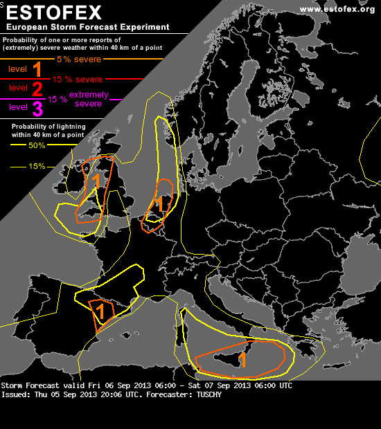
A level 1 was issued for far NE France, parts of Belgium and the Netherlands mainly for large hail, strong to severe wind gusts and an isolated tornado event.
DISCUSSION
... NE France, Belgium, the Netherlands and the S-North Sea ...
Low-tropospheric streamline forecasts show a broad convergent flow regime over the area of interest, created by increasing cyclonic (SW-erly) flow in response to the approaching upper low / the evolving surface depression and the outflow from the NE-ward departing surface high over the Baltic Sea. A leisurely SE-ward moving cold front becomes more active/progressive during the development of the surface low and moves in from the NW during the forecast. Models were persistent in showing a prefrontal convergence zone to affect the area of interest well ahead of the actual cold front. This pattern supports a deepening BL moisture layer ahead of those fronts with increasing BL dewpoints during the forecast.
At upper levels, a mid-level impulse/IPV anomaly crosses France from SW to NE and affects Benelux during peak time heating. This impulse however weakens due to another, much stronger one digging south to its west, so there is some uncertainty, how strong this feature will finally be. Hence NWP solutions are diverse especially with thunderstorm coverage and also with placement to some degree.
A plume of steeper mid-level lapse rates overspreads the area and moves atop the aforementioned moist BL. Some diabatic heating is possible and forecast soundings show a rapid destabilization trend of the prefrontal air mass. GFS remains consistent with 1-2 kJ/kg MLCAPE, WRF showing 1-1.5 kJ/kg and EZ now seems to agree on .6 to 1 kJ/kg.
Shear will peak during the passage of the weak impulse, which has a perfect timing as it crosses Benelux during peak heating. 20 m/s DLS along and ahead of the front and 15 m/s 0-3 km shear along the front itself create enough shear for organized DMC.
Most models agree well in CI over far NE France around noon, as forcing, increasing CAPE and approaching front/prefrontal convergence zones convene. 25-30 kt SW-erly storm motion vectors indicate rapid NE-ward motion of that convection towards W-Belgium and the Netherlands, where environmental conditions remain supportive for organized DMC. Models diverge a bit, if convection remains attached to the convergence zone, riding more to the north and hence offshore, or if the convection becomes detached and races to the NE and hence remains more onshore. Obviously the latter scenario would be of greater concern, as a few organized multicell/isolated supercell events are possible. Latest 12Z (5th Sept.) NWP guidance had a consistent shift of the main activity to the east, so confidence in the second scenario increased. It remains questionable, if discrete convection verifies, given the small angle of storm motion vector to the eastward sliding boundaries. Current expectation is to see numerous showers / thunderstorms with only a few of them becoming longer lived/severe. Final strength of the impulse, exact timing of the boundary and degree of prefrontal heating determine the final risk. Large hail and strong to isolated severe wind gusts will be probable, especially in case 15-20 m/s 3 km bulk shear verifies, which could support a few bowing line segments with an enhanced severe wind gust risk. As the surface low deepens to the NW, ageostrophic deflection of the BL wind also enhances LL shear. As LCLs drop to below 1 km over parts of W/C Netherlands and W-Belgium during the late afternoon hours, an isolated tornado event can occur.
The activity grows upscale into a thunderstorm cluster, which moves offshore and affects parts of the North Sea during the overnight hours within a N-ward expanding MUCAPE tongue.
A level area was issued, where confidence in organized DMC is the highest. Further east (e.g. NW Germany), weak convergence signals and diffuse mid-level forcing kept the confidence below a level area for now. In case a longer lived storm is able to evolve, large hail and strong to severe wind gusts would be the primary hazard.
DISCUSSION
... NE France, Belgium, the Netherlands and the S-North Sea ...
Low-tropospheric streamline forecasts show a broad convergent flow regime over the area of interest, created by increasing cyclonic (SW-erly) flow in response to the approaching upper low / the evolving surface depression and the outflow from the NE-ward departing surface high over the Baltic Sea. A leisurely SE-ward moving cold front becomes more active/progressive during the development of the surface low and moves in from the NW during the forecast. Models were persistent in showing a prefrontal convergence zone to affect the area of interest well ahead of the actual cold front. This pattern supports a deepening BL moisture layer ahead of those fronts with increasing BL dewpoints during the forecast.
At upper levels, a mid-level impulse/IPV anomaly crosses France from SW to NE and affects Benelux during peak time heating. This impulse however weakens due to another, much stronger one digging south to its west, so there is some uncertainty, how strong this feature will finally be. Hence NWP solutions are diverse especially with thunderstorm coverage and also with placement to some degree.
A plume of steeper mid-level lapse rates overspreads the area and moves atop the aforementioned moist BL. Some diabatic heating is possible and forecast soundings show a rapid destabilization trend of the prefrontal air mass. GFS remains consistent with 1-2 kJ/kg MLCAPE, WRF showing 1-1.5 kJ/kg and EZ now seems to agree on .6 to 1 kJ/kg.
Shear will peak during the passage of the weak impulse, which has a perfect timing as it crosses Benelux during peak heating. 20 m/s DLS along and ahead of the front and 15 m/s 0-3 km shear along the front itself create enough shear for organized DMC.
Most models agree well in CI over far NE France around noon, as forcing, increasing CAPE and approaching front/prefrontal convergence zones convene. 25-30 kt SW-erly storm motion vectors indicate rapid NE-ward motion of that convection towards W-Belgium and the Netherlands, where environmental conditions remain supportive for organized DMC. Models diverge a bit, if convection remains attached to the convergence zone, riding more to the north and hence offshore, or if the convection becomes detached and races to the NE and hence remains more onshore. Obviously the latter scenario would be of greater concern, as a few organized multicell/isolated supercell events are possible. Latest 12Z (5th Sept.) NWP guidance had a consistent shift of the main activity to the east, so confidence in the second scenario increased. It remains questionable, if discrete convection verifies, given the small angle of storm motion vector to the eastward sliding boundaries. Current expectation is to see numerous showers / thunderstorms with only a few of them becoming longer lived/severe. Final strength of the impulse, exact timing of the boundary and degree of prefrontal heating determine the final risk. Large hail and strong to isolated severe wind gusts will be probable, especially in case 15-20 m/s 3 km bulk shear verifies, which could support a few bowing line segments with an enhanced severe wind gust risk. As the surface low deepens to the NW, ageostrophic deflection of the BL wind also enhances LL shear. As LCLs drop to below 1 km over parts of W/C Netherlands and W-Belgium during the late afternoon hours, an isolated tornado event can occur.
The activity grows upscale into a thunderstorm cluster, which moves offshore and affects parts of the North Sea during the overnight hours within a N-ward expanding MUCAPE tongue.
A level area was issued, where confidence in organized DMC is the highest. Further east (e.g. NW Germany), weak convergence signals and diffuse mid-level forcing kept the confidence below a level area for now. In case a longer lived storm is able to evolve, large hail and strong to severe wind gusts would be the primary hazard.