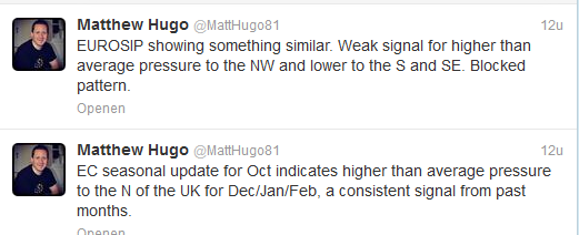
Gisteren is een tweet verschenen over EC en EUROSIP seizoensverwachting.
EUROSIP is de combinatie van EC, UKMO en MeteoFrance seizoensverwachting.
The October update of the EC seasonal and EUROSIP which for the record combines the EC Seasonal, UKMO, NCEP and MeteoFrance long range models, both signal a generally higher than average pressure anom to the N through D/J/F. The EC seasonal is more noteworthy and has a marked 500hpa anom to the N of the UK, as a mean over the three months. The EUROSIP has a weaker signal and this displaced to the NW near Iceland/Greenland with lower pressure just to the S or SE. Neither models do or have for the last few months at least signaled any sort of winter period that looks set to be dominated by a persistent zonal and general +NAO pattern.
http://forum.netweather.tv/topic/78161-stratosphere-temperature-watch-20132014/page-2
http://www.wcrp-climate.org/wgsip/wgsip12/reports/EUROSIP.pdf
Quote selectie
EUROSIP is de combinatie van EC, UKMO en MeteoFrance seizoensverwachting.
The October update of the EC seasonal and EUROSIP which for the record combines the EC Seasonal, UKMO, NCEP and MeteoFrance long range models, both signal a generally higher than average pressure anom to the N through D/J/F. The EC seasonal is more noteworthy and has a marked 500hpa anom to the N of the UK, as a mean over the three months. The EUROSIP has a weaker signal and this displaced to the NW near Iceland/Greenland with lower pressure just to the S or SE. Neither models do or have for the last few months at least signaled any sort of winter period that looks set to be dominated by a persistent zonal and general +NAO pattern.
http://forum.netweather.tv/topic/78161-stratosphere-temperature-watch-20132014/page-2
http://www.wcrp-climate.org/wgsip/wgsip12/reports/EUROSIP.pdf
Quote selectie
„Et nul ne se connait tant qu'il n'a pas souffert, „C'est une dure loi, mais une loi suprème, „Vieille comme le monde et la fatalité, „Qu'l nous faut du malheur regevoir le baptéme, ~Et qu'a ce triste prix tout doit étre acheté. „Les moissons pour murir out besoin de rosée, „Pour vivre et pour sentir l'homme a besoin de pleura, „La joie a pour symbole une plante brisée, „Humide encore de pluie et couverte de fleurs."

