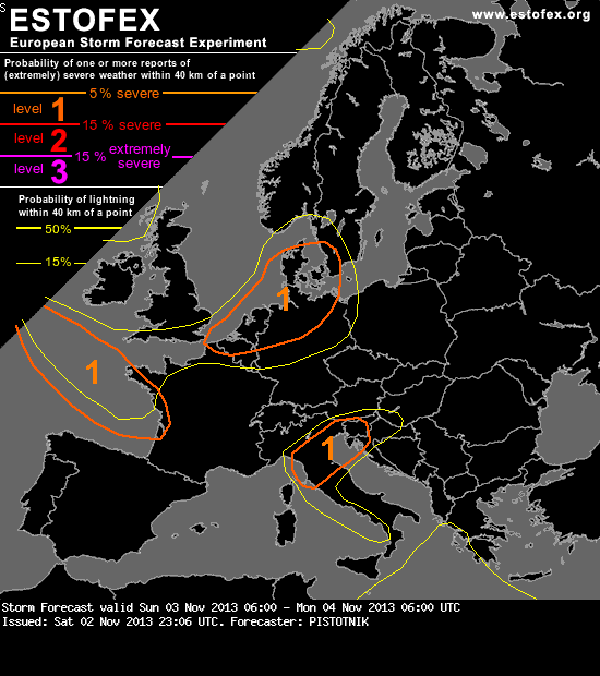
A level 1 was issued for parts of Belgium, the Netherlands, N Germany, Denmark and S Sweden for severe wind gusts.
SYNOPSIS
The active weather episode continues over most of Europe. A steering upper-level low slowly moves from the North Sea to Southern Norway. To its South, a broad and strong zonal flow covers most of the continent. A pronounced short-wave trough swings from France towards the Baltics and Belarus during the forecast period, getting an increasing negative tilt and gradually decoupling from a well-marked cold front which moves southeastward across Central Europe.
In the wake of this first system, a weaker second trough and the left exit region of a strong Atlantic jet streak will approach Western Europe again in the second half of the forecast period. Their QG lift will initiate the development of a pronounced frontal wave that is forecast to move across Southern England to the Netherlands Sunday night, extending and reinforcing this very windy period.
Instability is seasonably scarce, but strong forcing and kinematics may allow convectively enhanced wind gusts above 25 m/s in several regions discussed below.
... Western Europe ...
Very windy conditions will return to France and BeNeLux in the warm sector of the new frontal wave Sunday night, but with stable stratification no convection is expected and gustiness will be limited. Only later some upper-level cooling and drying on top of mild and very moist lower levels will enter the Bay of Biscay, which - together with strong QG lift - will likely result in the build-up and release of weak potential instability. Consequently, the stratiform rain shield is expected to break up into convective cells or line segments, which will more efficiently mix down the momentum from higher levels. At least localized severe wind gusts are expected with this process in the Bay of Biscay Sunday night and along the coast of Western France towards Monday morning.
The surface cold front itself will move leisurely southward over Southern England and the channel region. It may be associated with a shallow and weakly electrified convective line, but (convectively enhanced) severe wind gusts are not expected any more, as the wind field relaxes quickly on the cold side of the frontal zone.
SYNOPSIS
The active weather episode continues over most of Europe. A steering upper-level low slowly moves from the North Sea to Southern Norway. To its South, a broad and strong zonal flow covers most of the continent. A pronounced short-wave trough swings from France towards the Baltics and Belarus during the forecast period, getting an increasing negative tilt and gradually decoupling from a well-marked cold front which moves southeastward across Central Europe.
In the wake of this first system, a weaker second trough and the left exit region of a strong Atlantic jet streak will approach Western Europe again in the second half of the forecast period. Their QG lift will initiate the development of a pronounced frontal wave that is forecast to move across Southern England to the Netherlands Sunday night, extending and reinforcing this very windy period.
Instability is seasonably scarce, but strong forcing and kinematics may allow convectively enhanced wind gusts above 25 m/s in several regions discussed below.
... Western Europe ...
Very windy conditions will return to France and BeNeLux in the warm sector of the new frontal wave Sunday night, but with stable stratification no convection is expected and gustiness will be limited. Only later some upper-level cooling and drying on top of mild and very moist lower levels will enter the Bay of Biscay, which - together with strong QG lift - will likely result in the build-up and release of weak potential instability. Consequently, the stratiform rain shield is expected to break up into convective cells or line segments, which will more efficiently mix down the momentum from higher levels. At least localized severe wind gusts are expected with this process in the Bay of Biscay Sunday night and along the coast of Western France towards Monday morning.
The surface cold front itself will move leisurely southward over Southern England and the channel region. It may be associated with a shallow and weakly electrified convective line, but (convectively enhanced) severe wind gusts are not expected any more, as the wind field relaxes quickly on the cold side of the frontal zone.