http://www.estofex.org/
Punt van aandacht lijkt bij de trog te liggen dus.
DISCUSSION
... Western Europe ...
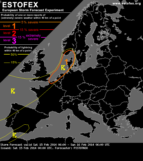
Scattered showers, a few of them weakly electrified, will form beneath a band of cold mid and upper levels, which pushes northeastward from the Bay of Biscay in the range of the main trough axis and well behind the surface cold front. The resulting marginal instability will partly overlap with a very strong background flow (30-40 m/s at 850 hPa) as it enters the North Sea. Isolated to scattered severe wind gusts are expected with the showers activity in coastal regions within the level 1 area, and even widespread ones on the open North Sea (albeit non-convective in nature further to the Northwest).
While most of the convection will stay unorganized, it is possible that a line of enhanced showers will move onshore in Belgium, the Netherlands, NW Germany and Denmark in the late afternoon to evening in association with a post-frontal wind shift line. With a temporary backing of the near-surface wind, very strong shear (20-25 m/s) and helicity (300-400 m^2/s^2) could be achieved in the lowest 3 km immediately ahead of this line, as the strong flow regime is reluctant to depart. This may result in a late maximum of the severe wind gust threat in the 15 to 21 UTC time frame, along with the possibility of one or two coastal tornadoes in case more discrete cells can crystallize. However, the lack of synoptic-scale lift support will limit the depth of the convection and precludes a level 2 despite a rather aggressive WRF solution.
Punt van aandacht lijkt bij de trog te liggen dus.
https://www.facebook.com/francois.debets.7/
