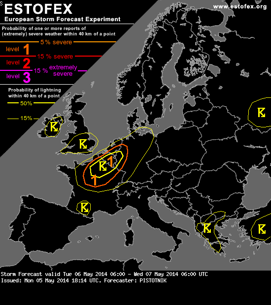
A level 1 was issued for parts of France, Belgium, the Netherlands, Luxemburg and W Germany mainly for tornadoes and severe wind gusts.
DISCUSSION
... BeNeLux, France, Germany ...
The frontal system of a surface low over the North Sea provides the main focus for deep convection. Its warm front moves over Germany, the Alpine region, the Czech Republic and Poland until the evening, while the cold front forms up along the continental coast of the Channel. In-between, a tongue of rich low-level moisture (8-9 g/kg) enters the warm sector with a 15 m/s low level jet from the SW.
A prominent feature on the forecast maps, and confirmed by latest satellite imagery, is a dry intrusion which is about to overrun the moist warm sector at higher levels. The cold front will then likely attain a well-marked "split front" character.
First convection my already emerge near the warm front in the afternoon hours, when it is crossed by one or two forerunning vorticity maxia over the N half of Germany. However, instability will likely be elevated and too weak for electrification. Confidence in the build-up of surface-based and more robust CAPE up to 400 J/kg increases further west, where stronger lift ahead of the main trough axis and cooling upper-levels enter the scene. Near the surface, weak warm air advection will likely persist till the evening, and the clearing of the upper-level clouds should allow a few hours of insolation.
Showers and thunderstorms are forecast to initiate near the French North coast in the afternoon and to spread eastward into BeNeLux and W Germany in the evening. Linear forcing and strong wind shear (0-6 km shear around 20 m/s, 0-3 km storm-relative helicity of 100-200 m^2/s^2, and 0-1 km shear in excess of 10 m/s) favour the development of a convective line. Isolated severe wind gusts are possible, and the combination of strong directional low-level shear and cloud bases around or below 1000m points to an enhanced tornado threat with any more discrete updraft that manages to form.
Further South, convective initiation will be more isolated over Central France, and an organization into multicells or even one or two supercells is possible. Severe wind gusts and an isolated tornado are possible with this activity as well, and localized hail approaching or exceeding 2 cm in size is not ruled out.
Convection will move deeper into Germany overnight, but will become elevated and will gradually lose its severe weather threat.
DISCUSSION
... BeNeLux, France, Germany ...
The frontal system of a surface low over the North Sea provides the main focus for deep convection. Its warm front moves over Germany, the Alpine region, the Czech Republic and Poland until the evening, while the cold front forms up along the continental coast of the Channel. In-between, a tongue of rich low-level moisture (8-9 g/kg) enters the warm sector with a 15 m/s low level jet from the SW.
A prominent feature on the forecast maps, and confirmed by latest satellite imagery, is a dry intrusion which is about to overrun the moist warm sector at higher levels. The cold front will then likely attain a well-marked "split front" character.
First convection my already emerge near the warm front in the afternoon hours, when it is crossed by one or two forerunning vorticity maxia over the N half of Germany. However, instability will likely be elevated and too weak for electrification. Confidence in the build-up of surface-based and more robust CAPE up to 400 J/kg increases further west, where stronger lift ahead of the main trough axis and cooling upper-levels enter the scene. Near the surface, weak warm air advection will likely persist till the evening, and the clearing of the upper-level clouds should allow a few hours of insolation.
Showers and thunderstorms are forecast to initiate near the French North coast in the afternoon and to spread eastward into BeNeLux and W Germany in the evening. Linear forcing and strong wind shear (0-6 km shear around 20 m/s, 0-3 km storm-relative helicity of 100-200 m^2/s^2, and 0-1 km shear in excess of 10 m/s) favour the development of a convective line. Isolated severe wind gusts are possible, and the combination of strong directional low-level shear and cloud bases around or below 1000m points to an enhanced tornado threat with any more discrete updraft that manages to form.
Further South, convective initiation will be more isolated over Central France, and an organization into multicells or even one or two supercells is possible. Severe wind gusts and an isolated tornado are possible with this activity as well, and localized hail approaching or exceeding 2 cm in size is not ruled out.
Convection will move deeper into Germany overnight, but will become elevated and will gradually lose its severe weather threat.
V?n?, v?d?, v?c?
