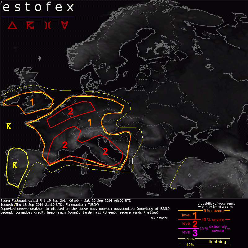
Estofex Level 2: grote hagelbollen, zware downburst mogelijk
Bericht van: Yannick (Tongeren-B) , 19-09-2014 03:12
A level 2 was issued for NE France, Belgium and parts of W-Germany mainly for large hail and excessive rain.
A level 1 surrounds both level 2s mainly for excessive rain, large hail and severe wind gusts.
... Rest of France, S-UK, Benelux and parts of Germany ...
Persistent advection of the marine layer from the W-Mediterranean towards France ensures deep and moist low-tropospheric profiles during the day. Hence, diurnal mixing should be suppressed and with mid-layer lapse rates of 7-8 K/km, MLCAPE forecasts of 1-2 kJ/kg seem reasonable. A forecast sounding just SW of Paris has MLCAPE of 2600 J/kg, PWs of 28 mm and less than 10 m/s of 6 km bulk shear. Differential heating helps to diminish CIN whereas residual outflow boundaries from yesterday's storms and the passage
of a weakneing mid-layer wave during peak heating induce enough forcing for widespread CI. Slow moving storms with torrential rain will be the main risk ... especially as storms grow upscale into numerous slow moving clusters. Initiating storms could bring large or very large hail and severe downbursts (LCLs above 1 km and augmented delta theta-e).An isolated tornado event can't be excluded due to enhanced LLCAPE along any convergence zone. This activity diminishes during the night, althoguh the air mass still supports severe events (large hail and excessive rain).
A similar kinematic/thermodynamic set-up extends towards Belgium and W/CNTRL Germany, where the same risks are
forecast. Concerns exist that with so much CAPE, an organized/long-lived cluster (MCS) could evolve over
CNTRL-France. SW-erly steering flow could bring any cluster towards W/NW Switzerland or SW/W-Germany. Aside from that, an E-W aligned convergence zone from N-France to W-Germany will be another focus for slow moving storms with excessive rain.
Further north, over S-UK, forecast soundings indicate less CAPE (1-1.5 kJ/kg), which is still noteworthy for this region. Persistent LL convergence signals, PWs in excess of 20 mm, weak upper divergence and storm motions of 5 kt point to an augmented risk for slow moving multicells with isolated large hail and excessive rain. High resolved models indicate selective amounts of 50 mm/3h, which would bring a flash flood threat to those areas. This risk also extends to S-Ireland and shifts north during the night, conform to the northbound advection of the unstable air.
A level 1 surrounds both level 2s mainly for excessive rain, large hail and severe wind gusts.
... Rest of France, S-UK, Benelux and parts of Germany ...
Persistent advection of the marine layer from the W-Mediterranean towards France ensures deep and moist low-tropospheric profiles during the day. Hence, diurnal mixing should be suppressed and with mid-layer lapse rates of 7-8 K/km, MLCAPE forecasts of 1-2 kJ/kg seem reasonable. A forecast sounding just SW of Paris has MLCAPE of 2600 J/kg, PWs of 28 mm and less than 10 m/s of 6 km bulk shear. Differential heating helps to diminish CIN whereas residual outflow boundaries from yesterday's storms and the passage
of a weakneing mid-layer wave during peak heating induce enough forcing for widespread CI. Slow moving storms with torrential rain will be the main risk ... especially as storms grow upscale into numerous slow moving clusters. Initiating storms could bring large or very large hail and severe downbursts (LCLs above 1 km and augmented delta theta-e).An isolated tornado event can't be excluded due to enhanced LLCAPE along any convergence zone. This activity diminishes during the night, althoguh the air mass still supports severe events (large hail and excessive rain).
A similar kinematic/thermodynamic set-up extends towards Belgium and W/CNTRL Germany, where the same risks are
forecast. Concerns exist that with so much CAPE, an organized/long-lived cluster (MCS) could evolve over
CNTRL-France. SW-erly steering flow could bring any cluster towards W/NW Switzerland or SW/W-Germany. Aside from that, an E-W aligned convergence zone from N-France to W-Germany will be another focus for slow moving storms with excessive rain.
Further north, over S-UK, forecast soundings indicate less CAPE (1-1.5 kJ/kg), which is still noteworthy for this region. Persistent LL convergence signals, PWs in excess of 20 mm, weak upper divergence and storm motions of 5 kt point to an augmented risk for slow moving multicells with isolated large hail and excessive rain. High resolved models indicate selective amounts of 50 mm/3h, which would bring a flash flood threat to those areas. This risk also extends to S-Ireland and shifts north during the night, conform to the northbound advection of the unstable air.