Een klein fragment uit het betoog van The Weather Centre (Canadees weerinstituut)mbt de aankomende winter in Noord Amerika.
Het hele verhaal via de link.
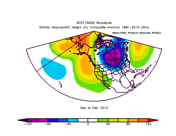
The above image shows a glimpse of mid-level height anomalies last winter, averaged out from December 2013 to February 2014. In this image, warm colors show positive height anomalies, resulting in quiet and warm weather. Similarly, cold colors indicate cold and stormy weather. If we look over at the United States, we see our friend, the polar vortex, in the position that brought us the horrendous cold in January and February.
But the vortex pushing so far south wasn't a random act of God. It was greatly influenced by that strip of positive height anomalies over the Northeast Pacific at the center of the image above.
And how did that body of positive height anomalies appear? That's right, it came from the warmer than normal water temperatures in the Gulf of Alaska.
If you put the pieces together, the climate pattern that made the winter so cold last year may very well return again this winter. This is because the warm waters in the Northeast Pacific are still here today, and if they remain there this winter, the chances of ridging appearing in that area are high, which could lead to another very cold winter. -
Het hele verhaal via de link.
The above image shows a glimpse of mid-level height anomalies last winter, averaged out from December 2013 to February 2014. In this image, warm colors show positive height anomalies, resulting in quiet and warm weather. Similarly, cold colors indicate cold and stormy weather. If we look over at the United States, we see our friend, the polar vortex, in the position that brought us the horrendous cold in January and February.
But the vortex pushing so far south wasn't a random act of God. It was greatly influenced by that strip of positive height anomalies over the Northeast Pacific at the center of the image above.
And how did that body of positive height anomalies appear? That's right, it came from the warmer than normal water temperatures in the Gulf of Alaska.
If you put the pieces together, the climate pattern that made the winter so cold last year may very well return again this winter. This is because the warm waters in the Northeast Pacific are still here today, and if they remain there this winter, the chances of ridging appearing in that area are high, which could lead to another very cold winter. -
http://oakcreekwx.com
