December 2014
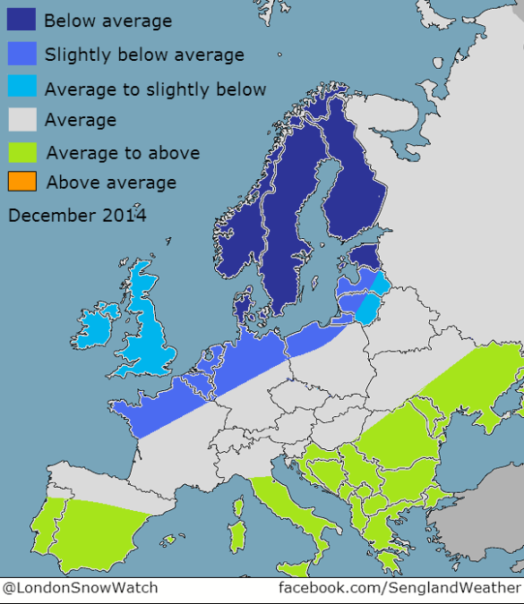
The problem is trying to figure out when we see the NAO flip negative. We can rule out the first 15 days of December, albeit the odd cold shot (northerly incursion) is possible. As already identified, the NAO flipping negative will be as a result of significant stresses put on the polar vortex via wave activity and subsequent warming and ultimately a SSW towards the end of December or into January. Wave 2 forecast out to day 10 is still quite weak. The vortex is forecast to strengthen into early December. Most SSW’s are preceded by a period of vortex cooling/intensification. I’d suggest the earliest point to see a SSW would be Christmas to New Year, with subsequent cold into January. That leaves December a mixed bag. The first half likely dominated by intermittent periods of high pressure further south, with frost/fog at times and more unsettled further north with hill snow at times. A small chance of fleeting cold shots in the north bringing some snow to lower levels is not ruled out during early December, but remains an outside chance. From mid month and for the second half of December, high pressure is likely to build over northern latitudes. Depending how much residual energy remains in the vicinity of Greenland, will have a large bearing on how December 20th – 31st pans out. I will put the chance of seeing a widespread cold/snowy spell at 20-30%. Should this occur, it will, of course, have a bearing on the December temperature forecast, but I’m sticking with average to slightly below for December as a whole.
The problem is trying to figure out when we see the NAO flip negative. We can rule out the first 15 days of December, albeit the odd cold shot (northerly incursion) is possible. As already identified, the NAO flipping negative will be as a result of significant stresses put on the polar vortex via wave activity and subsequent warming and ultimately a SSW towards the end of December or into January. Wave 2 forecast out to day 10 is still quite weak. The vortex is forecast to strengthen into early December. Most SSW’s are preceded by a period of vortex cooling/intensification. I’d suggest the earliest point to see a SSW would be Christmas to New Year, with subsequent cold into January. That leaves December a mixed bag. The first half likely dominated by intermittent periods of high pressure further south, with frost/fog at times and more unsettled further north with hill snow at times. A small chance of fleeting cold shots in the north bringing some snow to lower levels is not ruled out during early December, but remains an outside chance. From mid month and for the second half of December, high pressure is likely to build over northern latitudes. Depending how much residual energy remains in the vicinity of Greenland, will have a large bearing on how December 20th – 31st pans out. I will put the chance of seeing a widespread cold/snowy spell at 20-30%. Should this occur, it will, of course, have a bearing on the December temperature forecast, but I’m sticking with average to slightly below for December as a whole.
There's no such thing as good weather, or bad weather. There's just weather and your attitude towards it.