Crippling Blizzard Heads For Northeast
UPDATED 7:15 AM EST, January 26, 2015
UPDATED By WeatherBug Meteorologists, Andrew Rosenthal and James West
A crippling, even historic nor`easter will batter the Interstate 95 corridor from New Jersey and Pennsylvania to New England.
As much as 2 to 3 feet of snow will fall by the time the storm winds down Wednesday, with damaging winds producing extremely dangerous travel conditions.
The approaching winter storm is currently a weak area of low pressure making its way across the Ohio Valley and into the Mid-Atlantic this morning. A ribbon of light snow has been falling across the Ohio Valley, where Pittsburgh has picked up about 2 inches of fresh snow. The low will slide southeastward later this morning, bringing a rain-and-snow mix to Baltimore and Washington, D.C.
Winter Weather Advisories stretch from central Ohio to Maryland and northern Virginia, with Winter Storm Warnings in the West Virginia and Maryland Appalachians. Accumulations today could reach an inch or two in the lower elevations, with 3 to 5 inches of snow across the mountains.
By this evening, the storm will slide off the coast, at which point it will be able to start feeding off of warm Atlantic moisture and rapidly strengthen. It will move northeastward toward the southern New England coast overnight, and then stall briefly along the Northeast U.S. Coast through mid-week. This will result in an extended burst of heavy, wet snow along the coast from New Jersey to eastern Maine, with areas of the Mid-Atlantic and interior Northeast taking a glancing blow from the storm.
A Blizzard Warning is in effect for Tuesday in the New York metro area, all of Connecticut and Rhode Island, eastern Massachusetts, southeastern New Hampshire and coastal Maine. This includes New York City, Long Island, Hartford, Conn., Boston, Providence, R.I., and Portland, Maine. Winter Storm Warningsextend from southern New Jersey and eastern Pennsylvania into northern Maine, including Philadelphia, Atlantic City, N.J., Albany, N.Y., Springfield, Mass., Concord, N.H., and Caribou, Maine. Winter Weather Advisories hug the western fringe of the warnings into the Mid-Atlantic, including Baltimore and Washington, D.C.
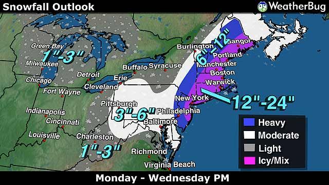
The highest snowfall amounts will be found across central and eastern New England, where accumulations of 20 to 30 inches are anticipated. This includes Hartford, Conn., and Boston. Areas just west of that, including the Lower Hudson Valley and New York City, as well as northern New England, will be at risk for a foot or more of fresh snowfall. Even areas as far south as Philadelphia and the Delmarva Peninsula could pick up several inches of snow on Monday night and Tuesday.
In addition, high winds sustained at 25 to 45 mph with gusts as high as 75 mph are expected, leading to near-zero visibilities and blizzard conditions. Gusts this strong will culminate in widespread power outages.
Already, numerous airlines have cancelled flights across the Northeast Corridor, which will likely have a cascading effect on travel across the U.S. Other modes of transportation will become impossible by Tuesday morning as the heavy snow and wind piles drifts on roads and rails alike. If you must travel, make sure to carry a winter survival kit that includes a shovel, flashlight, blankets, water and non-perishable food.
At home, have blankets and flashlights ready in case power goes out. Remember, open flames such as fireplaces and candles can easily spark fires, which could be exacerbated by the strong winds.
By the time this major nor`easter unravels on Wednesday, accumulations could be in the record books. It could rival New York`s biggest snow, set in 2006 when 27 inches fell. Hartford, Conn., and Boston will also make a run at the record territory, where the latter could ultimately rank higher than the Blizzard of 1978.
Be sure to keep WeatherBug active to receive the latest weather in your neighborhood and get the latest updates anywhere on Twitter.
UPDATED 7:15 AM EST, January 26, 2015
UPDATED By WeatherBug Meteorologists, Andrew Rosenthal and James West
A crippling, even historic nor`easter will batter the Interstate 95 corridor from New Jersey and Pennsylvania to New England.
As much as 2 to 3 feet of snow will fall by the time the storm winds down Wednesday, with damaging winds producing extremely dangerous travel conditions.
The approaching winter storm is currently a weak area of low pressure making its way across the Ohio Valley and into the Mid-Atlantic this morning. A ribbon of light snow has been falling across the Ohio Valley, where Pittsburgh has picked up about 2 inches of fresh snow. The low will slide southeastward later this morning, bringing a rain-and-snow mix to Baltimore and Washington, D.C.
Winter Weather Advisories stretch from central Ohio to Maryland and northern Virginia, with Winter Storm Warnings in the West Virginia and Maryland Appalachians. Accumulations today could reach an inch or two in the lower elevations, with 3 to 5 inches of snow across the mountains.
By this evening, the storm will slide off the coast, at which point it will be able to start feeding off of warm Atlantic moisture and rapidly strengthen. It will move northeastward toward the southern New England coast overnight, and then stall briefly along the Northeast U.S. Coast through mid-week. This will result in an extended burst of heavy, wet snow along the coast from New Jersey to eastern Maine, with areas of the Mid-Atlantic and interior Northeast taking a glancing blow from the storm.
A Blizzard Warning is in effect for Tuesday in the New York metro area, all of Connecticut and Rhode Island, eastern Massachusetts, southeastern New Hampshire and coastal Maine. This includes New York City, Long Island, Hartford, Conn., Boston, Providence, R.I., and Portland, Maine. Winter Storm Warningsextend from southern New Jersey and eastern Pennsylvania into northern Maine, including Philadelphia, Atlantic City, N.J., Albany, N.Y., Springfield, Mass., Concord, N.H., and Caribou, Maine. Winter Weather Advisories hug the western fringe of the warnings into the Mid-Atlantic, including Baltimore and Washington, D.C.
The highest snowfall amounts will be found across central and eastern New England, where accumulations of 20 to 30 inches are anticipated. This includes Hartford, Conn., and Boston. Areas just west of that, including the Lower Hudson Valley and New York City, as well as northern New England, will be at risk for a foot or more of fresh snowfall. Even areas as far south as Philadelphia and the Delmarva Peninsula could pick up several inches of snow on Monday night and Tuesday.
In addition, high winds sustained at 25 to 45 mph with gusts as high as 75 mph are expected, leading to near-zero visibilities and blizzard conditions. Gusts this strong will culminate in widespread power outages.
Already, numerous airlines have cancelled flights across the Northeast Corridor, which will likely have a cascading effect on travel across the U.S. Other modes of transportation will become impossible by Tuesday morning as the heavy snow and wind piles drifts on roads and rails alike. If you must travel, make sure to carry a winter survival kit that includes a shovel, flashlight, blankets, water and non-perishable food.
At home, have blankets and flashlights ready in case power goes out. Remember, open flames such as fireplaces and candles can easily spark fires, which could be exacerbated by the strong winds.
By the time this major nor`easter unravels on Wednesday, accumulations could be in the record books. It could rival New York`s biggest snow, set in 2006 when 27 inches fell. Hartford, Conn., and Boston will also make a run at the record territory, where the latter could ultimately rank higher than the Blizzard of 1978.
Be sure to keep WeatherBug active to receive the latest weather in your neighborhood and get the latest updates anywhere on Twitter.
Bericht laatst bijgewerkt: 26-01-2015 19:23