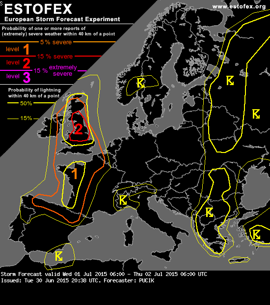
Mooi om te lezen dat er wel veel potentie is voor mogelijk zware buien (met name boven de UK), maar dat de onzekerheid nog parten speelt. Zo'n situatie krijgen wij dus donderdag?
Storm Forecast
Valid: Wed 01 Jul 2015 06:00 to Thu 02 Jul 2015 06:00 UTC
Issued: Tue 30 Jun 2015 20:38
Forecaster: PUCIK
A level 1 was issued for W France mainly for severe wind gusts and large hail.
SYNOPSIS
An omega-type pattern is observed over Europe with a highly amplified ridge stretching from the Mediterranean towards S Scandinavia. On the western flank of the ridge, hot airmass along with an elevated mixed layer will be advected from Iberia towards United Kingdom in the 15-20 m/s of 700 hPa flow. As steep lapse rates are advected over the moister low-level airmass in strong shear regime, potentially severe situation will develop from S France towards N UK. Major uncertainity will be the convective initiation.
Different thunderstorm regime will exist over E Europe, where instability develops thanks to the cool mid-tropospheric temperatures. Here, initiation will be easily achieved after the diurnal heating commences. However, due to the weak wind shear, well organised convection is not expected.
... W France ...
Due to the capping, initiation of storms will be very late, perhaps apart from already ongoing elevated convection early in the forecast period over NW France. First initiation signals are over the Pyrennees or over SW France around 18 UTC. After this time, models agree on development and rapid northward movement of an MCS, which should develop as the trough approaches region from SW. However, there are discrepancies in the exact track - either over the Bay of Biscay or over extreme SW France. Very strong 0-3 km wind shear with values over 20 m/s would imply significant wind gust threat. However, due to the fact that instability will likely be elevated during the night hours, it is questionable if downdrafts will be able to penetrate stabilising boundary layer. This factor prevents us from issuing a Lvl 2 for the severe wind gusts attm, albeit a conditional chance for long swath of severe wind gusts will exist. Also, large hail may occur even with elevated storms, thanks to the very steep lapse rates.
Storm Forecast
Valid: Wed 01 Jul 2015 06:00 to Thu 02 Jul 2015 06:00 UTC
Issued: Tue 30 Jun 2015 20:38
Forecaster: PUCIK
A level 1 was issued for W France mainly for severe wind gusts and large hail.
SYNOPSIS
An omega-type pattern is observed over Europe with a highly amplified ridge stretching from the Mediterranean towards S Scandinavia. On the western flank of the ridge, hot airmass along with an elevated mixed layer will be advected from Iberia towards United Kingdom in the 15-20 m/s of 700 hPa flow. As steep lapse rates are advected over the moister low-level airmass in strong shear regime, potentially severe situation will develop from S France towards N UK. Major uncertainity will be the convective initiation.
Different thunderstorm regime will exist over E Europe, where instability develops thanks to the cool mid-tropospheric temperatures. Here, initiation will be easily achieved after the diurnal heating commences. However, due to the weak wind shear, well organised convection is not expected.
... W France ...
Due to the capping, initiation of storms will be very late, perhaps apart from already ongoing elevated convection early in the forecast period over NW France. First initiation signals are over the Pyrennees or over SW France around 18 UTC. After this time, models agree on development and rapid northward movement of an MCS, which should develop as the trough approaches region from SW. However, there are discrepancies in the exact track - either over the Bay of Biscay or over extreme SW France. Very strong 0-3 km wind shear with values over 20 m/s would imply significant wind gust threat. However, due to the fact that instability will likely be elevated during the night hours, it is questionable if downdrafts will be able to penetrate stabilising boundary layer. This factor prevents us from issuing a Lvl 2 for the severe wind gusts attm, albeit a conditional chance for long swath of severe wind gusts will exist. Also, large hail may occur even with elevated storms, thanks to the very steep lapse rates.