Waarschuwing dit bericht bevat spoilers  &
& 
Al eerder berichtte ik over de UKMO winterverwachting. Zie http://www.weerwoord.be/includes/forum_read.php?id=2126277&tid=2126277&exp=1 & http://www.weerwoord.be/includes/forum_read.php?id=2117536&tid=2117536&exp=1
De laatste uitdraai is al een week of twee bekend, maar ik had nog geen eerder tijd om het te plaatsen. Te druk met records
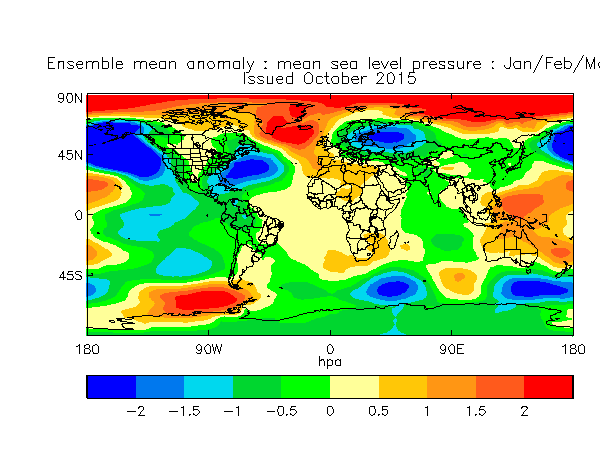
Volgens de laatste inzichten (volgens UKMO) neemt de kans op een SSW toe, dit dan voor de tweede helft van de winter. Daarentegen wijzen alle modellen op een positieve NAO aan het begin het winterseizoen. Dit doen ze consistent en stevig.
BBC weerman Ian Fergusson: The latest Contingency Planning summary is N-D-J. That GloSea5 output is J-F-M. Note cautionary comment by seasonal team re increased SSW potential late season in today's update. In other words, the message remains consistent: coherent, cross-model support for notion of milder/wetter/poss stormier start to winter, but potential for colder flip later (this clearly v uncertain of course). But the notion of broadly +ve NAO conditions into winter at least initially has been strongly signalled by the key output (GloSea5, EC Seasonal, EuroSip) for a while now.
& Al eerder berichtte ik over de UKMO winterverwachting. Zie http://www.weerwoord.be/includes/forum_read.php?id=2126277&tid=2126277&exp=1 & http://www.weerwoord.be/includes/forum_read.php?id=2117536&tid=2117536&exp=1
De laatste uitdraai is al een week of twee bekend, maar ik had nog geen eerder tijd om het te plaatsen. Te druk met records
Volgens de laatste inzichten (volgens UKMO) neemt de kans op een SSW toe, dit dan voor de tweede helft van de winter. Daarentegen wijzen alle modellen op een positieve NAO aan het begin het winterseizoen. Dit doen ze consistent en stevig.
BBC weerman Ian Fergusson: The latest Contingency Planning summary is N-D-J. That GloSea5 output is J-F-M. Note cautionary comment by seasonal team re increased SSW potential late season in today's update. In other words, the message remains consistent: coherent, cross-model support for notion of milder/wetter/poss stormier start to winter, but potential for colder flip later (this clearly v uncertain of course). But the notion of broadly +ve NAO conditions into winter at least initially has been strongly signalled by the key output (GloSea5, EC Seasonal, EuroSip) for a while now.
„Et nul ne se connait tant qu'il n'a pas souffert, „C'est une dure loi, mais une loi suprème, „Vieille comme le monde et la fatalité, „Qu'l nous faut du malheur regevoir le baptéme, ~Et qu'a ce triste prix tout doit étre acheté. „Les moissons pour murir out besoin de rosée, „Pour vivre et pour sentir l'homme a besoin de pleura, „La joie a pour symbole une plante brisée, „Humide encore de pluie et couverte de fleurs."
